

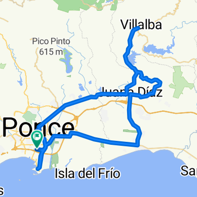
Ruta: Ponce-Collores-Villalba-Ponce
Trasa rowerowa rozpoczynająca się w Ponce, Ponce Municipio, Puerto Rico.
Przegląd
O tej trasie
ROUTE: Ponce-Collores- Villalba-Juana Díaz-Ponce Start point:Med Centro, Ponce Farthest Point:Downtown Villalba End Point:Med Centro, Ponce Distance:34mi/55km Total Time:3:30 hr Moving Time:2:40 hr Avg Moving Speed:13 mph Elevation Gain:1,750 ft Calories:1,600 to 2,000
ROUTE DESCRIPTION: This is a good route for avid cyclists who are not necessarily aiming to do competitive cycling. First 10 miles are comprised by flat and mild hills. Following 4 miles are is a more steep climbing to the highest point of the route, followed by a2 mile descent. The rest is a hilly roller coaster throughout the route. Last 5 miles is a very moderate descent passing through downtown Ponce until the End Point. Route is all paved and is suitable for either MTB or Road bikes. However, be aware that roads may have unknown damaged pave at times. This is a very enjoyable route throughout countryside PR. Cyclists moderately trained should be able to complete it with ease. Great to be done with pals and share a great time together.
- -:--
- Czas
- 55,2 km
- Dystans
- 388 m
- Przewyższenia
- 386 m
- Spadek
- ---
- Śr. Prędkość
- ---
- Maks. wysokość
Jakość trasy
Typy dróg i nawierzchnie na trasie
Typy dróg
Droga
26,6 km
(48 %)
Ruchliwa droga
22,5 km
(41 %)
Powierzchnie
Utwardzona
4,1 km
(7 %)
Asfalt
4,1 km
(7 %)
Niezdefiniowany
51,2 km
(93 %)
Kontynuuj z Bikemap
Użyj, edytuj lub pobierz tę trasę rowerową
Chcesz przejechać trasę Ruta: Ponce-Collores-Villalba-Ponce lub dostosować ją do swojej wycieczki? Oto, co możesz zrobić z tą trasą na Bikemap:
Darmowe funkcje
- Zapisz tę trasę jako ulubioną lub w kolekcji
- Skopiuj i zaplanuj swoją wersję tej trasy
- Synchronizuj swoją trasę z Garminem lub Wahoo
Funkcje Premium
3 dni bezpłatnej wersji próbnej lub jednorazowa opłata. Dowiedz się więcej o Bikemap Premium.
- Nawiguj po tej trasie na iOS i Androidzie
- Eksportuj plik GPX / KML tej trasy
- Stwórz swój własny wydruk (wypróbuj za darmo)
- Pobierz tę trasę do nawigacji offline
Odkryj więcej funkcji Premium.
Uzyskaj Bikemap PremiumOd naszej społeczności
Ponce: Inne popularne trasy rozpoczynające się tutaj
 Tour of the Caribbean - Stage 3: Ponce - San Juan
- Dystans
- 121,8 km
- Przewyższenia
- 1005 m
- Spadek
- 1014 m
- Lokalizacja
- Ponce, Ponce Municipio, Puerto Rico
 Light Workout
- Dystans
- 4,7 km
- Przewyższenia
- 25 m
- Spadek
- 26 m
- Lokalizacja
- Ponce, Ponce Municipio, Puerto Rico
 MED BIKE RALLY LONG RUTE MOUNTAIN BIKE ROUTE
- Dystans
- 76,5 km
- Przewyższenia
- 420 m
- Spadek
- 420 m
- Lokalizacja
- Ponce, Ponce Municipio, Puerto Rico
 Martes De Bicicleta
- Dystans
- 13,4 km
- Przewyższenia
- 22 m
- Spadek
- 21 m
- Lokalizacja
- Ponce, Ponce Municipio, Puerto Rico
 Ruta: Ponce-Collores-Villalba-Ponce
- Dystans
- 55,2 km
- Przewyższenia
- 388 m
- Spadek
- 386 m
- Lokalizacja
- Ponce, Ponce Municipio, Puerto Rico
 MBR - Ruta Larga - 50M-80K
- Dystans
- 79,5 km
- Przewyższenia
- 418 m
- Spadek
- 417 m
- Lokalizacja
- Ponce, Ponce Municipio, Puerto Rico
 Med Centro-Collores-Villaba-JDiaz-Med Centro
- Dystans
- 55,2 km
- Przewyższenia
- 393 m
- Spadek
- 390 m
- Lokalizacja
- Ponce, Ponce Municipio, Puerto Rico
 MED BIKE RALLY LONG ROUTE STREET BIKE
- Dystans
- 69,7 km
- Przewyższenia
- 434 m
- Spadek
- 434 m
- Lokalizacja
- Ponce, Ponce Municipio, Puerto Rico
Otwórz ją w aplikacji