

NL Rhine Cycle Route
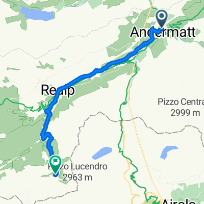
Trasa rowerowa rozpoczynająca się w Andermatt, Uri, Szwajcaria.
Przegląd
O tej trasie
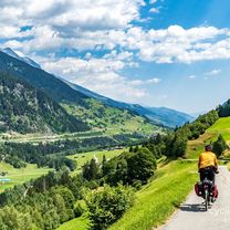
Trasa rowerowa nad Renem ma około 1360 kilometrów i prowadzi przez pięć krajów. Trasa zaczyna się w Alpach szwajcarskich – w obszarze źródłowym Renu. Następnie prowadzi przez Austrię, Francję i Niemcy. Trasa kończy się w Rotterdamie w Holandii, gdzie Ren wpada do Morza Północnego.
- -:--
- Czas
- 1365,4 km
- Dystans
- 12 m
- Przewyższenia
- 1447 m
- Spadek
- ---
- Śr. Prędkość
- ---
- Maks. wysokość

Jakość trasy
Typy dróg i nawierzchnie na trasie
Typy dróg
Droga leśna
368,7 km
(27 %)
Spokojna droga
286,7 km
(21 %)
Powierzchnie
Utwardzona
887,5 km
(65 %)
Nieutwardzona
286,7 km
(21 %)
Asfalt
860,2 km
(63 %)
Żwir
177,5 km
(13 %)
Najważniejsze punkty trasy
Punkty zainteresowania na trasie

Interesujące miejsce po 299,4 km
The Rhine Falls (Rheinfall in German) is the largest plain waterfall in Europe. They are 150 m wide and 23 m high.

Interesujące miejsce po 675,2 km
Speyer is one of the oldest cities in Germany and is therefore historically and culturally important. Most famous is the Imperial Cathedral of Speyer.

Interesujące miejsce po 839,2 km
The Lorelei is a rock on the eastern bank of the Rhine which soars some 120 metres above the waterline. It marks the narrowest part of the river between Switzerland and the North Sea, and is the most famous feature of the Rhine Gorge, a 65 km section of the river between Koblenz and Bingen that was added to the UNESCO World Heritage Sites in June 2002. A very strong current and rocks below the waterline have caused many boat accidents there. Lorelei is also the name of a feminine water spirit, similar to mermaids or Rhine maidens, associated with this rock in popular folklore and in works of music, art and literature.

Interesujące miejsce po 903,5 km
One of Andernach's natural attractions is the world's highest (max. 64 m) cold-water geyser, driven by carbon dioxide with force generated in a fashion similar to that in a shaken bottle of table water.
Kontynuuj z Bikemap
Użyj, edytuj lub pobierz tę trasę rowerową
Chcesz przejechać trasę NL Rhine Cycle Route lub dostosować ją do swojej wycieczki? Oto, co możesz zrobić z tą trasą na Bikemap:
Darmowe funkcje
- Zapisz tę trasę jako ulubioną lub w kolekcji
- Skopiuj i zaplanuj swoją wersję tej trasy
- Podziel trasę na etapy, aby utworzyć kilkudniową wycieczkę
- Synchronizuj swoją trasę z Garminem lub Wahoo
Funkcje Premium
3 dni bezpłatnej wersji próbnej lub jednorazowa opłata. Dowiedz się więcej o Bikemap Premium.
- Nawiguj po tej trasie na iOS i Androidzie
- Eksportuj plik GPX / KML tej trasy
- Stwórz swój własny wydruk (wypróbuj za darmo)
- Pobierz tę trasę do nawigacji offline
Odkryj więcej funkcji Premium.
Uzyskaj Bikemap PremiumOd naszej społeczności
Andermatt: Inne popularne trasy rozpoczynające się tutaj
 giro dei tre passi susten grimsel furka
- Dystans
- 132,9 km
- Przewyższenia
- 3457 m
- Spadek
- 3601 m
- Lokalizacja
- Andermatt, Uri, Szwajcaria
 Rhine Cycle Route, EuroVelo 15 - Andermatt to Basel
- Dystans
- 492,2 km
- Przewyższenia
- 6424 m
- Spadek
- 7590 m
- Lokalizacja
- Andermatt, Uri, Szwajcaria
 Andermatt 3
- Dystans
- 158,9 km
- Przewyższenia
- 3905 m
- Spadek
- 3702 m
- Lokalizacja
- Andermatt, Uri, Szwajcaria
 Witenwasseren Bike
- Dystans
- 17,3 km
- Przewyższenia
- 808 m
- Spadek
- 26 m
- Lokalizacja
- Andermatt, Uri, Szwajcaria
 Bellinzona - Vizzola Ticino
- Dystans
- 130,7 km
- Przewyższenia
- 2639 m
- Spadek
- 3799 m
- Lokalizacja
- Andermatt, Uri, Szwajcaria
 Rheinradweg
- Dystans
- 1085,7 km
- Przewyższenia
- 107 m
- Spadek
- 1544 m
- Lokalizacja
- Andermatt, Uri, Szwajcaria
 VR01 Furkapass Belvedere-Brig.kml - VR01 Furkapass Belvedere-Brig.kml_VR01 Furkapass Belvedere-Brig
- Dystans
- 60,1 km
- Przewyższenia
- 852 m
- Spadek
- 2409 m
- Lokalizacja
- Andermatt, Uri, Szwajcaria
 20.09.2010 Furka, Nufenen, Gotthard
- Dystans
- 98,5 km
- Przewyższenia
- 2959 m
- Spadek
- 2959 m
- Lokalizacja
- Andermatt, Uri, Szwajcaria
Otwórz ją w aplikacji