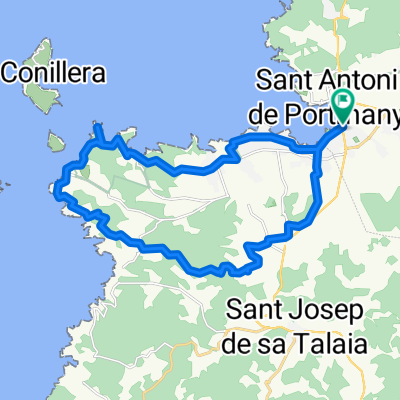
CALA JONDAL
Trasa rowerowa rozpoczynająca się w Sant Antoni de Portmany, Balearic Islands, Spain.
Przegląd
O tej trasie
<div> This route is designed for lovers of countryside and mountain. It is a tour</div> <div> that requires us to have a good level of cycling proficiency and proven</div> <div> physical fitness. That said, we enjoy a journey that shows us the interior</div> <div> of the island's far southwest, introducing us to traditional crops,</div> <div> impressive views and winding lanes while we pass through woods and</div> <div> fields which, especially in spring, overflow with colour and Mediterranean</div> <div> essence.</div> <div> We begin by pedalling along asphalt but immediately exit from the paved</div> <div> route and immerse ourselves in a network of paths, tracks and trails that</div> <div> we do not leave until we have almost finished.</div> <div> During the almost 40-kilometres route we experience an approximate</div> <div> 900 metres' difference in altitude which we tackle at two accessible</div> <div> climbs, first, Capelleta, and second, Sa Talaia, although we do not arrive</div> <div> at their summits.</div> <div> Halfway through the journey -if the weather is right- it is almost</div> <div> impossible not to make the most of the brilliant waters of Cala Jondal or</div> <div> Porroig and take a refreshing dip. Afterwards, we climb halfway up the</div> <div> mountain of Sa Talaia, crossing impressive valleys full of local flora and</div> <div> fauna, and return to Sant Antoni through small, pretty fields of crops in</div> <div> more relaxing terrain.</div>
- -:--
- Czas
- 38 km
- Dystans
- 651 m
- Przewyższenia
- 654 m
- Spadek
- ---
- Śr. Prędkość
- ---
- Maks. wysokość
Kontynuuj z Bikemap
Użyj, edytuj lub pobierz tę trasę rowerową
Chcesz przejechać trasę CALA JONDAL lub dostosować ją do swojej wycieczki? Oto, co możesz zrobić z tą trasą na Bikemap:
Darmowe funkcje
- Zapisz tę trasę jako ulubioną lub w kolekcji
- Skopiuj i zaplanuj swoją wersję tej trasy
- Synchronizuj swoją trasę z Garminem lub Wahoo
Funkcje Premium
3 dni bezpłatnej wersji próbnej lub jednorazowa opłata. Dowiedz się więcej o Bikemap Premium.
- Nawiguj po tej trasie na iOS i Androidzie
- Eksportuj plik GPX / KML tej trasy
- Stwórz swój własny wydruk (wypróbuj za darmo)
- Pobierz tę trasę do nawigacji offline
Odkryj więcej funkcji Premium.
Uzyskaj Bikemap PremiumOd naszej społeczności
Sant Antoni de Portmany: Inne popularne trasy rozpoczynające się tutaj
 X Vuelta Cicloturismo Ibiza - 2ª etapa
- Dystans
- 101,5 km
- Przewyższenia
- 982 m
- Spadek
- 977 m
- Lokalizacja
- Sant Antoni de Portmany, Balearic Islands, Spain
 Cala de Bou - Corona - Buscastell . Cala de Bou
- Dystans
- 29,6 km
- Przewyższenia
- 326 m
- Spadek
- 327 m
- Lokalizacja
- Sant Antoni de Portmany, Balearic Islands, Spain
 Cala de Bou - Jesús - Salinas - Sant Jordi
- Dystans
- 40,2 km
- Przewyższenia
- 254 m
- Spadek
- 266 m
- Lokalizacja
- Sant Antoni de Portmany, Balearic Islands, Spain
 CALA JONDAL
- Dystans
- 38 km
- Przewyższenia
- 651 m
- Spadek
- 654 m
- Lokalizacja
- Sant Antoni de Portmany, Balearic Islands, Spain
 San Antonio - Formentera - Aeropuerto
- Dystans
- 143,5 km
- Przewyższenia
- 483 m
- Spadek
- 491 m
- Lokalizacja
- Sant Antoni de Portmany, Balearic Islands, Spain
 Ibiza. Vuelta cicloturista. Etapa 3 (84km)
- Dystans
- 84,5 km
- Przewyższenia
- 640 m
- Spadek
- 643 m
- Lokalizacja
- Sant Antoni de Portmany, Balearic Islands, Spain
 Sant Antoni de Portmany til Denia
- Dystans
- 106,7 km
- Przewyższenia
- 0 m
- Spadek
- 0 m
- Lokalizacja
- Sant Antoni de Portmany, Balearic Islands, Spain
 Trasa nr 8
- Dystans
- 26,7 km
- Przewyższenia
- 357 m
- Spadek
- 358 m
- Lokalizacja
- Sant Antoni de Portmany, Balearic Islands, Spain
Otwórz ją w aplikacji

