Von Kingussie Versuch nach Fort Augustus
- 47,4 km
- 644 m
- 531 m
- Kingussie, Szkocja, Zjednoczone Królestwo Wielkiej Brytanii
Trasa rowerowa rozpoczynająca się w Kingussie, Szkocja, Zjednoczone Królestwo Wielkiej Brytanii.
Przegląd
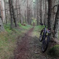
This is a relatively short route of 12km / 7.5 miles suitable for mountain bikes. Some sections are on tarmac but others are on rough paths and for one section the bike will need to be carried.<br /> Allow 2 hours.<br /> Ordinance Survey sheet 35 Kingussie and Monadliath Mountains.<br /> Refreshments: Cafes and bars in Kingussie and Newtonmore.<br /> <br /> Start in the centre of Kingussie by taking the Ardbroilach Road opposite the Star Hotel.<br /> Follow the road for about a mile following the waymarks for the Golf Course walk. When the waymarks turn left continue to follow this route and cross the Gynack over a bridge. The path at this point becomes steep with steps for a short section when the bike will have to be carried. Continue to follow the path and pass an abandoned cottage. Pass through a gate and enter woodland. The next section is a rough unsurfaced path but mostly navigable by mountain bike. <br /> As the path emerges out of the wood Loch Gynack now comes into view. Pass though another gate and follow the trail to the left uphill for a short incline. There is a junction here for the Kingussie paths network maintained by the Kingussie Community Development Company (KCDC).<br /> Follow the waymark to Newtonmore and from here the route leads through birchwoods alongside the loch. The surface is now much better.<br /> When the route emerges into the open again continue to follow the waymarks for Newtonmore and bear to the right onto a well-surfaced gravel track running alongside a plantation of pine. As the trees come to an end, pass through a gate and follow the waymark downhill to the left on a Land Rover track. When the track meets a tarmac road, turn left to go downhill and down to the Newtonmore Main Street.<br /> Turn left and on Main Street for 50 metres and pass the Highland Folk Museum. Just after the museum turn right to take the off-road cycle path back to Kingussie.<br /> <br /> Bikefast Scotland @ Kingussie
utworzono 11 lat temu temu
Najważniejsze punkty trasy

Bridge over Gynack burn

path with steps

Loch Gynack

Junction to Newtonmore

View to Creag Dhubh

KCDC waymark

Kingussie to Newtonmore cycle route
Kontynuuj z Bikemap
Chcesz przejechać trasę Kingussie, Loch Gynack and Newtonmore lub dostosować ją do swojej wycieczki? Oto, co możesz zrobić z tą trasą na Bikemap:
3 dni bezpłatnej wersji próbnej lub jednorazowa opłata. Dowiedz się więcej o Bikemap Premium.
Odkryj więcej funkcji Premium.
Uzyskaj Bikemap PremiumOd naszej społeczności
Otwórz ją w aplikacji