

Tissington and High Peak Trails (and the roady thing to join up the ends)
Trasa rowerowa rozpoczynająca się w Ashbourne, Anglia, Zjednoczone Królestwo Wielkiej Brytanii.
Przegląd
O tej trasie
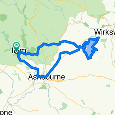
Startowałem w Ashbourne, podjeżdżając szlakiem Tissington, który ma bardzo, bardzo łagodne i dość uciążliwe wzniesienie przez jakieś pierwsze pięć mil. Potem się wyrównuje i reszta jest całkowicie płaska, z wieloma małymi miejscami do odpoczynku, w tym Hartington Signal Box. Do Parsley Hay, zrób obrót o 180 stopni i wróć szlakiem High Peak Trail, który jest równie płaski i ma dobrą nawierzchnię. Dwa spady w pobliżu końca Cromford, oba na korzyść rowerzystów w tę stronę! Pod koniec drugiego spadu zjeżdżam z trasy na prawo i dojeżdżam drogami ostatni odcinek powrotny do Ashbourne – znacznie bardziej pagórkowaty (kilka ładnych zjazdów) i kierowcy są idiotami. Kilka pubów, jeśli masz na to ochotę....
- -:--
- Czas
- 55,6 km
- Dystans
- 437 m
- Przewyższenia
- 437 m
- Spadek
- ---
- Śr. Prędkość
- ---
- Maks. wysokość

Jakość trasy
Typy dróg i nawierzchnie na trasie
Typy dróg
Droga rowerowa
40,6 km
(73 %)
Ścieżka
1,1 km
(2 %)
Powierzchnie
Utwardzona
5,6 km
(10 %)
Nieutwardzona
40 km
(72 %)
Żwir
40 km
(72 %)
Asfalt
5,6 km
(10 %)
Niezdefiniowany
10 km
(18 %)
Kontynuuj z Bikemap
Użyj, edytuj lub pobierz tę trasę rowerową
Chcesz przejechać trasę Tissington and High Peak Trails (and the roady thing to join up the ends) lub dostosować ją do swojej wycieczki? Oto, co możesz zrobić z tą trasą na Bikemap:
Darmowe funkcje
- Zapisz tę trasę jako ulubioną lub w kolekcji
- Skopiuj i zaplanuj swoją wersję tej trasy
- Synchronizuj swoją trasę z Garminem lub Wahoo
Funkcje Premium
3 dni bezpłatnej wersji próbnej lub jednorazowa opłata. Dowiedz się więcej o Bikemap Premium.
- Nawiguj po tej trasie na iOS i Androidzie
- Eksportuj plik GPX / KML tej trasy
- Stwórz swój własny wydruk (wypróbuj za darmo)
- Pobierz tę trasę do nawigacji offline
Odkryj więcej funkcji Premium.
Uzyskaj Bikemap PremiumOd naszej społeczności
Ashbourne: Inne popularne trasy rozpoczynające się tutaj
 ride in the peak district
- Dystans
- 50,1 km
- Przewyższenia
- 723 m
- Spadek
- 723 m
- Lokalizacja
- Ashbourne, Anglia, Zjednoczone Królestwo Wielkiej Brytanii
 Trissington circle
- Dystans
- 28 km
- Przewyższenia
- 311 m
- Spadek
- 305 m
- Lokalizacja
- Ashbourne, Anglia, Zjednoczone Królestwo Wielkiej Brytanii
 Milldale - Hall Dale Walk
- Dystans
- 10,5 km
- Przewyższenia
- 247 m
- Spadek
- 248 m
- Lokalizacja
- Ashbourne, Anglia, Zjednoczone Królestwo Wielkiej Brytanii
 Tissington Trail
- Dystans
- 39,8 km
- Przewyższenia
- 518 m
- Spadek
- 486 m
- Lokalizacja
- Ashbourne, Anglia, Zjednoczone Królestwo Wielkiej Brytanii
 Thorpe - Youlgreave - Darley Bridge - Matlock - Riber - Cromford - Wirksworth - Kirk Ireton - Carsington Water - Tissington - Thorpe
- Dystans
- 69 km
- Przewyższenia
- 867 m
- Spadek
- 868 m
- Lokalizacja
- Ashbourne, Anglia, Zjednoczone Królestwo Wielkiej Brytanii
 09.2018 Cov-M'cr-Cov. Dzien 2/3
- Dystans
- 59,4 km
- Przewyższenia
- 491 m
- Spadek
- 783 m
- Lokalizacja
- Ashbourne, Anglia, Zjednoczone Królestwo Wielkiej Brytanii
 Tissington and High Peak Trails (and the roady thing to join up the ends)
- Dystans
- 55,6 km
- Przewyższenia
- 437 m
- Spadek
- 437 m
- Lokalizacja
- Ashbourne, Anglia, Zjednoczone Królestwo Wielkiej Brytanii
 Route 10 Carsington Water circular
- Dystans
- 43,6 km
- Przewyższenia
- 513 m
- Spadek
- 514 m
- Lokalizacja
- Ashbourne, Anglia, Zjednoczone Królestwo Wielkiej Brytanii
Otwórz ją w aplikacji