Tha Phae Road Soi do Tha Phae Road Soi
- 23,4 km
- 71 m
- 71 m
- Cziang Maj, Prowincja Chiang Mai, Tajlandia
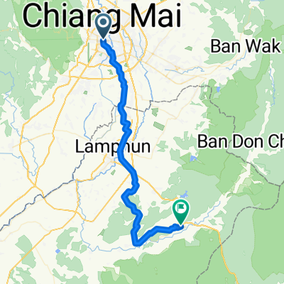
Trasa rowerowa rozpoczynająca się w Cziang Maj, Prowincja Chiang Mai, Tajlandia.
Przegląd
This trip begins in the southern city district of Chang Khlan and runs along the banks of river Ping to the border of Lamphun and back. First follow the road on the western bank leading south (downstream). The tarmac road is not very wide, but in good condition. From Saraphi on, there is considerably less traffic. If you go all the way down to the Lamphun border, the scenery becomes quite rural and you will pass through Longan orchards, fields, and villages. Turn around at Lamphun and follow the eastern bank north (upstream) back to Chiang Mai.<br /> <br /> There are several interesting spots for sight-seeing that potentially turn this into a full-day trip: 1. an optional detour to the city of Lamphun at the southernmost point (+1-2 hours), 2. an optional detour to the beautiful park of the century-old McKean rehabilitation centre (+0.5 hours), and 3. exploration of the ancient ruins and tempels of Wiang Kum Kam between the two outer ring roads (+1 hour).
(cloned from route 2325497)utworzono 11 lat temu temu
Jakość trasy
Droga
33,5 km
(75 %)
Spokojna droga
9,8 km
(22 %)
Utwardzona
44,2 km
(99 %)
Asfalt
31,7 km
(71 %)
Beton
6,7 km
(15 %)
Najważniejsze punkty trasy
Lamphun city
McKean Rehabilitation Centre
Kontynuuj z Bikemap
Chcesz przejechać trasę River Ping Southern Route lub dostosować ją do swojej wycieczki? Oto, co możesz zrobić z tą trasą na Bikemap:
3 dni bezpłatnej wersji próbnej lub jednorazowa opłata. Dowiedz się więcej o Bikemap Premium.
Odkryj więcej funkcji Premium.
Uzyskaj Bikemap PremiumOd naszej społeczności
Otwórz ją w aplikacji