

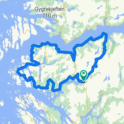
Rock cycling in Haugsdalen and Engleberget
Trasa rowerowa rozpoczynająca się w Mo, Hordaland Fylke, Norwegia.
Przegląd
O tej trasie
This is a tour with single track and some playgrounds for rock cycling.
Go to the end of the construcion road at Svartavanet in Haugsdalen valley. Bike, drive by car or hire lift from Matre, one hour north of Bergen. Turn downvards and take left. Follow a single track, andthen our own way in naure andon rock down to the road. Follow the road back 700m and tak left. Leave the road just before the bridge, and a playground of soft rock is in front of you. You can fllow both sides f theriver, but normally I cross the river short distanse under the bridge, and follow on the right hand side. Depentend of the level of water in the lake, you cross in the north side of the lake. If full it ismaybe easiest to climbup the hill. Normally you cntinue to a ne playground with soft rocks untill you reach the road. Follow the road 2 km south were it is possible to have a short tip to the left. Then 300m ahead leave the road again, and the playground at Engleberget i in front of you. Find your way on the rocks down to the lake. Follow on the left/east side around the lake. In the inner part you choose your own level of difficulty for playing. On the last part back to the road there are flat smooth rocks. Full susension bike is higly recomended. Hire: www.bergfritid.no <div style="left: -1000px; top: 105.2px; width: 1px; height: 1px; overflow: hidden; position: absolute;"> </div> <div style="left: -1000px; top: 441.2px; width: 1px; height: 1px; overflow: hidden; position: absolute;"> </div>
- -:--
- Czas
- 11,5 km
- Dystans
- 557 m
- Przewyższenia
- 694 m
- Spadek
- ---
- Śr. Prędkość
- ---
- Maks. wysokość

Kontynuuj z Bikemap
Użyj, edytuj lub pobierz tę trasę rowerową
Chcesz przejechać trasę Rock cycling in Haugsdalen and Engleberget lub dostosować ją do swojej wycieczki? Oto, co możesz zrobić z tą trasą na Bikemap:
Darmowe funkcje
- Zapisz tę trasę jako ulubioną lub w kolekcji
- Skopiuj i zaplanuj swoją wersję tej trasy
- Synchronizuj swoją trasę z Garminem lub Wahoo
Funkcje Premium
3 dni bezpłatnej wersji próbnej lub jednorazowa opłata. Dowiedz się więcej o Bikemap Premium.
- Nawiguj po tej trasie na iOS i Androidzie
- Eksportuj plik GPX / KML tej trasy
- Stwórz swój własny wydruk (wypróbuj za darmo)
- Pobierz tę trasę do nawigacji offline
Odkryj więcej funkcji Premium.
Uzyskaj Bikemap PremiumOd naszej społeczności
Mo: Inne popularne trasy rozpoczynające się tutaj
 BF7 Matre Slovag
- Dystans
- 45,2 km
- Przewyższenia
- 1310 m
- Spadek
- 1690 m
- Lokalizacja
- Mo, Hordaland Fylke, Norwegia
 Stølsheimen Vest: Fjordsykkelruta
- Dystans
- 217,5 km
- Przewyższenia
- 2041 m
- Spadek
- 2041 m
- Lokalizacja
- Mo, Hordaland Fylke, Norwegia
 BF3 Anleggsveien Stordalen
- Dystans
- 10,6 km
- Przewyższenia
- 355 m
- Spadek
- 440 m
- Lokalizacja
- Mo, Hordaland Fylke, Norwegia
 BF4 Anleggsveien Haugsdalen Svartavatnet
- Dystans
- 32,5 km
- Przewyższenia
- 2767 m
- Spadek
- 3227 m
- Lokalizacja
- Mo, Hordaland Fylke, Norwegia
 Stølsheimen rundt
- Dystans
- 294,2 km
- Przewyższenia
- 4628 m
- Spadek
- 4628 m
- Lokalizacja
- Mo, Hordaland Fylke, Norwegia
 Stølsheimen Vest: Fjordsykkelruta
- Dystans
- 217,5 km
- Przewyższenia
- 1751 m
- Spadek
- 1735 m
- Lokalizacja
- Mo, Hordaland Fylke, Norwegia
 BF2 Haugsdalen
- Dystans
- 13,5 km
- Przewyższenia
- 2285 m
- Spadek
- 2285 m
- Lokalizacja
- Mo, Hordaland Fylke, Norwegia
 BF1 Matresdalen
- Dystans
- 4,8 km
- Przewyższenia
- 759 m
- Spadek
- 499 m
- Lokalizacja
- Mo, Hordaland Fylke, Norwegia
Otwórz ją w aplikacji