

Wärm dich auf
Trasa rowerowa rozpoczynająca się w Werdum, Dolna Saksonia, Niemcy.
Przegląd
O tej trasie
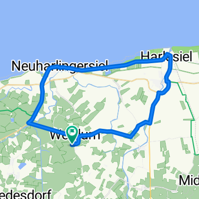
Start/Meta: Werdum Parking przed halą sportową / Gastriege 5,6 Kilometrów
Ta trasa jest idealną wycieczką dla początkujących. Poznaj wieś Werdum. Poczzątkowa trasa w miejscowości zgadza się z trasami innych, więc możesz także spontanicznie wybrać dłuższą trasę. Daj się oczarować malowniczym krajobrazem i beztroską naturą. Rozpoczynamy na parkingu przed halą sportową, skąd zostaniesz poprowadzony przez oznakowanie przez wieś Werdum. Po 700m opuszczasz wieś i kierujesz się w stronę Thunum. Tutaj idziesz cały czas prosto, mijając łąki i pola, aż po 2,8 km dotrzesz do małego mostu. Rozkoszuj się pięknem natury, zatrzymaj się i nabierz energii przed powrotem. Po 5,6 km wracasz do punktu wyjścia, naładowany i z pewnością chętny na więcej.
Stowarzyszenie Kurverein Neuharlingersiel e.V. Edo-Edzards-Str. 1 26427 Nordseeheilbad Neuharlingersiel Telefon: (04974) 1880 E-mail: info@neuharlingersiel.de www.neuharlingersiel.de www.facebook.com/neuharlingersiel
- -:--
- Czas
- 5,7 km
- Dystans
- 0 m
- Przewyższenia
- 0 m
- Spadek
- ---
- Śr. Prędkość
- ---
- Maks. wysokość

Jakość trasy
Typy dróg i nawierzchnie na trasie
Typy dróg
Droga leśna
3,6 km
(63 %)
Spokojna droga
1,7 km
(30 %)
Powierzchnie
Utwardzona
0,2 km
(4 %)
Asfalt
0,2 km
(4 %)
Niezdefiniowany
5,5 km
(96 %)
Kontynuuj z Bikemap
Użyj, edytuj lub pobierz tę trasę rowerową
Chcesz przejechać trasę Wärm dich auf lub dostosować ją do swojej wycieczki? Oto, co możesz zrobić z tą trasą na Bikemap:
Darmowe funkcje
- Zapisz tę trasę jako ulubioną lub w kolekcji
- Skopiuj i zaplanuj swoją wersję tej trasy
- Synchronizuj swoją trasę z Garminem lub Wahoo
Funkcje Premium
3 dni bezpłatnej wersji próbnej lub jednorazowa opłata. Dowiedz się więcej o Bikemap Premium.
- Nawiguj po tej trasie na iOS i Androidzie
- Eksportuj plik GPX / KML tej trasy
- Stwórz swój własny wydruk (wypróbuj za darmo)
- Pobierz tę trasę do nawigacji offline
Odkryj więcej funkcji Premium.
Uzyskaj Bikemap PremiumOd naszej społeczności
Werdum: Inne popularne trasy rozpoczynające się tutaj
 Route 7
- Dystans
- 20,4 km
- Przewyższenia
- 9 m
- Spadek
- 8 m
- Lokalizacja
- Werdum, Dolna Saksonia, Niemcy
 W-Carolinensiel-Neuharlingensiel-W
- Dystans
- 26,6 km
- Przewyższenia
- 10 m
- Spadek
- 10 m
- Lokalizacja
- Werdum, Dolna Saksonia, Niemcy
 Werdum-Dornum-Werdum
- Dystans
- 53 km
- Przewyższenia
- 13 m
- Spadek
- 12 m
- Lokalizacja
- Werdum, Dolna Saksonia, Niemcy
 Route 8
- Dystans
- 19,1 km
- Przewyższenia
- 23 m
- Spadek
- 22 m
- Lokalizacja
- Werdum, Dolna Saksonia, Niemcy
 Zum Strand
- Dystans
- 27,1 km
- Przewyższenia
- 0 m
- Spadek
- 0 m
- Lokalizacja
- Werdum, Dolna Saksonia, Niemcy
 Schillig - Dornum
- Dystans
- 71 km
- Przewyższenia
- 10 m
- Spadek
- 10 m
- Lokalizacja
- Werdum, Dolna Saksonia, Niemcy
 Werdum - Varel
- Dystans
- 93,3 km
- Przewyższenia
- 17 m
- Spadek
- 6 m
- Lokalizacja
- Werdum, Dolna Saksonia, Niemcy
 18 WerdumEmden
- Dystans
- 65,4 km
- Przewyższenia
- 40 m
- Spadek
- 36 m
- Lokalizacja
- Werdum, Dolna Saksonia, Niemcy
Otwórz ją w aplikacji