

CB2014
CB2014#4 - Villeneuve s/ Lot La Réole
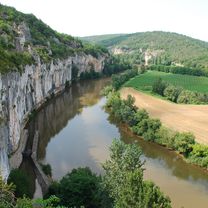
Trasa rowerowa rozpoczynająca się w Villeneuve-sur-Lot, Nouvelle-Aquitaine, Francja.
Przegląd
O tej trasie
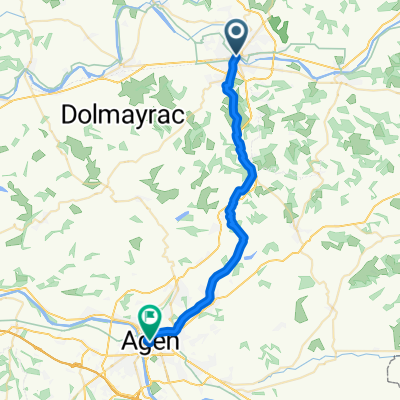
CB2014#4 - Villeneuve s/ Lot La Réole
- -:--
- Czas
- 105 km
- Dystans
- 156 m
- Przewyższenia
- 182 m
- Spadek
- ---
- Śr. Prędkość
- ---
- Maks. wysokość

Część
CB2014
7 etapów
Jakość trasy
Typy dróg i nawierzchnie na trasie
Typy dróg
Spokojna droga
35,7 km
(34 %)
Droga
30,5 km
(29 %)
Powierzchnie
Utwardzona
47,3 km
(45 %)
Asfalt
47,3 km
(45 %)
Niezdefiniowany
57,8 km
(55 %)
Kontynuuj z Bikemap
Użyj, edytuj lub pobierz tę trasę rowerową
Chcesz przejechać trasę CB2014#4 - Villeneuve s/ Lot La Réole lub dostosować ją do swojej wycieczki? Oto, co możesz zrobić z tą trasą na Bikemap:
Darmowe funkcje
- Zapisz tę trasę jako ulubioną lub w kolekcji
- Skopiuj i zaplanuj swoją wersję tej trasy
- Podziel trasę na etapy, aby utworzyć kilkudniową wycieczkę
- Synchronizuj swoją trasę z Garminem lub Wahoo
Funkcje Premium
3 dni bezpłatnej wersji próbnej lub jednorazowa opłata. Dowiedz się więcej o Bikemap Premium.
- Nawiguj po tej trasie na iOS i Androidzie
- Eksportuj plik GPX / KML tej trasy
- Stwórz swój własny wydruk (wypróbuj za darmo)
- Pobierz tę trasę do nawigacji offline
Odkryj więcej funkcji Premium.
Uzyskaj Bikemap PremiumOd naszej społeczności
Villeneuve-sur-Lot: Inne popularne trasy rozpoczynające się tutaj
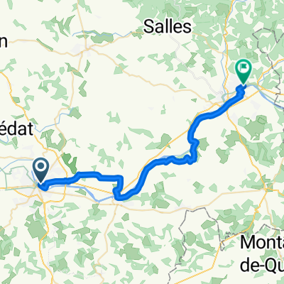
 Étape 7
- Dystans
- 31,5 km
- Przewyższenia
- 333 m
- Spadek
- 334 m
- Lokalizacja
- Villeneuve-sur-Lot, Nouvelle-Aquitaine, Francja
 Day 21
- Dystans
- 84,5 km
- Przewyższenia
- 242 m
- Spadek
- 226 m
- Lokalizacja
- Villeneuve-sur-Lot, Nouvelle-Aquitaine, Francja
 20140514 - Villeneuve sur Lot - Cahors
- Dystans
- 104,6 km
- Przewyższenia
- 431 m
- Spadek
- 363 m
- Lokalizacja
- Villeneuve-sur-Lot, Nouvelle-Aquitaine, Francja
 Villeneuve-sur-Lot (47300), Lot-et-Garonne, Nouvelle-Aquitaine, France - Carlux (24370), Dordogne, Nouvelle-Aquitaine, France
- Dystans
- 120,1 km
- Przewyższenia
- 1795 m
- Spadek
- 1669 m
- Lokalizacja
- Villeneuve-sur-Lot, Nouvelle-Aquitaine, Francja
 fumel_villeneuve sur lot
- Dystans
- 34,7 km
- Przewyższenia
- 208 m
- Spadek
- 154 m
- Lokalizacja
- Villeneuve-sur-Lot, Nouvelle-Aquitaine, Francja
 CB2014#4 - Villeneuve s/ Lot La Réole
- Dystans
- 105 km
- Przewyższenia
- 156 m
- Spadek
- 182 m
- Lokalizacja
- Villeneuve-sur-Lot, Nouvelle-Aquitaine, Francja
 Villeneuve-sur-Lot - Tarbes
- Dystans
- 173,6 km
- Przewyższenia
- 894 m
- Spadek
- 644 m
- Lokalizacja
- Villeneuve-sur-Lot, Nouvelle-Aquitaine, Francja
 Verkenning Frankrijk 2022
- Dystans
- 40,3 km
- Przewyższenia
- 171 m
- Spadek
- 170 m
- Lokalizacja
- Villeneuve-sur-Lot, Nouvelle-Aquitaine, Francja
Otwórz ją w aplikacji