Rhone-Alpes: Etappe 2
Trasa rowerowa rozpoczynająca się w Albertville, Owernia-Rodan-Alpy, Francja.
Przegląd
O tej trasie
Start: Albertville
- Col de la Madeleine Meta: St. Jean de Maurienne- -:--
- Czas
- 75,1 km
- Dystans
- 1903 m
- Przewyższenia
- 1673 m
- Spadek
- ---
- Śr. Prędkość
- ---
- Maks. wysokość
Jakość trasy
Typy dróg i nawierzchnie na trasie
Typy dróg
Droga
3,8 km
(5 %)
Spokojna droga
3,8 km
(5 %)
Powierzchnie
Utwardzona
54,1 km
(72 %)
Asfalt
54,1 km
(72 %)
Niezdefiniowany
21 km
(28 %)
Najważniejsze punkty trasy
Punkty zainteresowania na trasie

Interesujące miejsce po 0 km
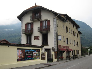
Auberge de Costaroche Adresse: 1 Chemin de la Pierre du Roy, 73200 Albertville, Frankreich Telefon:+33 4 79 32 02 02

Interesujące miejsce po 12,9 km
Wasserstelle

Interesujące miejsce po 18,3 km
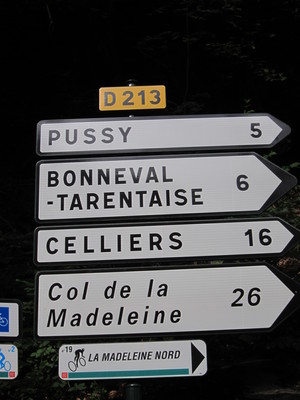
Einfahrt in den Col de la Madeleine

Interesujące miejsce po 28,5 km
Brücke

Interesujące miejsce po 41,5 km
Nicht mehr weit

Interesujące miejsce po 42,4 km
Col de la Madeleine, 1993m

Interesujące miejsce po 75,1 km
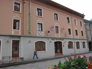
Hotel St. Georges Adresse: 334 Rue de la République, 73300 Saint-Jean-de-Maurienne, Frankreich Telefon:+33 4 79 64 01 06
Kontynuuj z Bikemap
Użyj, edytuj lub pobierz tę trasę rowerową
Chcesz przejechać trasę Rhone-Alpes: Etappe 2 lub dostosować ją do swojej wycieczki? Oto, co możesz zrobić z tą trasą na Bikemap:
Darmowe funkcje
- Zapisz tę trasę jako ulubioną lub w kolekcji
- Skopiuj i zaplanuj swoją wersję tej trasy
- Synchronizuj swoją trasę z Garminem lub Wahoo
Funkcje Premium
3 dni bezpłatnej wersji próbnej lub jednorazowa opłata. Dowiedz się więcej o Bikemap Premium.
- Nawiguj po tej trasie na iOS i Androidzie
- Eksportuj plik GPX / KML tej trasy
- Stwórz swój własny wydruk (wypróbuj za darmo)
- Pobierz tę trasę do nawigacji offline
Odkryj więcej funkcji Premium.
Uzyskaj Bikemap PremiumOd naszej społeczności
Albertville: Inne popularne trasy rozpoczynające się tutaj
 marthod1
- Dystans
- 17,9 km
- Przewyższenia
- 912 m
- Spadek
- 31 m
- Lokalizacja
- Albertville, Owernia-Rodan-Alpy, Francja
 Tour de France 2016 - Stage 19
- Dystans
- 154,5 km
- Przewyższenia
- 3656 m
- Spadek
- 2625 m
- Lokalizacja
- Albertville, Owernia-Rodan-Alpy, Francja
 D'ALBERTVILLE A ANNECY 50KMS ENVIRON
- Dystans
- 46,5 km
- Przewyższenia
- 199 m
- Spadek
- 86 m
- Lokalizacja
- Albertville, Owernia-Rodan-Alpy, Francja
 09-D. Albertville - Roche Béranger (151,2 Km)
- Dystans
- 151,2 km
- Przewyższenia
- 4491 m
- Spadek
- 3035 m
- Lokalizacja
- Albertville, Owernia-Rodan-Alpy, Francja
 Albertville, Col de l'Arpettaz, Albertville.
- Dystans
- 60,6 km
- Przewyższenia
- 1285 m
- Spadek
- 1285 m
- Lokalizacja
- Albertville, Owernia-Rodan-Alpy, Francja
 albertville - colle delle finestre (italy)
- Dystans
- 197,2 km
- Przewyższenia
- 4734 m
- Spadek
- 3088 m
- Lokalizacja
- Albertville, Owernia-Rodan-Alpy, Francja
 20.07 IX etapp Albertville - Saint-Jean-de-Maurienne
- Dystans
- 81,2 km
- Przewyższenia
- 1975 m
- Spadek
- 1860 m
- Lokalizacja
- Albertville, Owernia-Rodan-Alpy, Francja
 Rhone-Alpes: Etappe 2
- Dystans
- 75,1 km
- Przewyższenia
- 1903 m
- Spadek
- 1673 m
- Lokalizacja
- Albertville, Owernia-Rodan-Alpy, Francja
Otwórz ją w aplikacji

