- 1915,7 km
- 1619 m
- 1003 m
- Tremont, Maine, USA
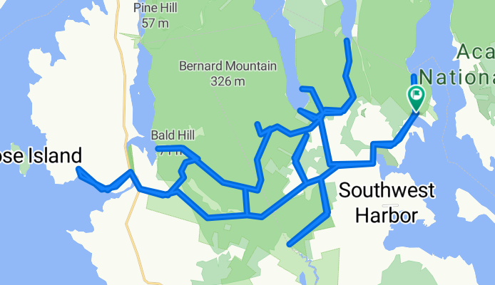
Western side of Acadia
Trasa rowerowa rozpoczynająca się w Tremont, Maine, USA.
Przegląd
O tej trasie
Ta trasa prowadzi około 65 % po drogach gruntowych (z krótkim odcinkiem nie-technicznego szlaku), a 35 % po asfalcie, i zawiera krótki odcinek nie-technicznego szlaku. Wiele z tych dróg gruntowych to jednopasmowe trasy znajdujące się w gęstym lesie, z zielonym mchem tworzącym poszycie lasu. Naprawdę miło jest w słoneczny dzień.
Na Cape Road znajduje się kilka stołów piknikowych w pobliżu małego portu i przystani. Jest tu wspaniały widok podczas podjadania Clif Bara.
Około 2/3 drogi jest droga pożarowa, która prowadzi cię do najdalej na południe wysuniętego punktu. Kończy się przy małym zbiorniku wodnym, który ostatecznie staje się Bass Harbor. Jest w środku niczego.
Parkując na początku szlaku do Flying Mtn.
- -:--
- Czas
- 44,7 km
- Dystans
- 420 m
- Przewyższenia
- 420 m
- Spadek
- ---
- Śr. Prędkość
- ---
- Maks. wysokość
utworzono 11 lat temu temu
Jakość trasy
Typy dróg i nawierzchnie na trasie
Typy dróg
Spokojna droga
26,8 km
(60 %)
Droga
7,6 km
(17 %)
Powierzchnie
Utwardzona
5,4 km
(12 %)
Nieutwardzona
17,4 km
(39 %)
Nieutwardzony (nieokreślony)
17,4 km
(39 %)
Asfalt
5,4 km
(12 %)
Niezdefiniowany
21,9 km
(49 %)
Najważniejsze punkty trasy
Punkty zainteresowania na trasie
Interesujące miejsce po 25,4 km
Picnic table with a great view while chewing on the Clif Bar.
Kontynuuj z Bikemap
Użyj, edytuj lub pobierz tę trasę rowerową
Chcesz przejechać trasę Western side of Acadia lub dostosować ją do swojej wycieczki? Oto, co możesz zrobić z tą trasą na Bikemap:
Darmowe funkcje
- Zapisz tę trasę jako ulubioną lub w kolekcji
- Skopiuj i zaplanuj swoją wersję tej trasy
- Synchronizuj swoją trasę z Garminem lub Wahoo
Funkcje Premium
3 dni bezpłatnej wersji próbnej lub jednorazowa opłata. Dowiedz się więcej o Bikemap Premium.
- Nawiguj po tej trasie na iOS i Androidzie
- Eksportuj plik GPX / KML tej trasy
- Stwórz swój własny wydruk (wypróbuj za darmo)
- Pobierz tę trasę do nawigacji offline
Odkryj więcej funkcji Premium.
Uzyskaj Bikemap PremiumOd naszej społeczności
Tremont: Inne popularne trasy rozpoczynające się tutaj
- Acadia-Shenadoah on the East Coast Greenway
- Around Mountain 7 Bridges
- 24,2 km
- 0 m
- 3 m
- Tremont, Maine, USA
- Western side of Acadia
- 44,7 km
- 420 m
- 420 m
- Tremont, Maine, USA
- southwest harbor to cadillac mt and back
- 47,2 km
- 593 m
- 602 m
- Tremont, Maine, USA
- Shore Road 117, Southwest Harbor to Seawall Point Lane 30, Southwest Harbor
- 3,1 km
- 14 m
- 22 m
- Tremont, Maine, USA
- Around Mountain & 7 Bridges
- 24,1 km
- 26 m
- 22 m
- Tremont, Maine, USA
- 7 Bridges
- 24,3 km
- 0 m
- 4 m
- Tremont, Maine, USA
- Ride with Gary
- 15,1 km
- 233 m
- 228 m
- Tremont, Maine, USA
Otwórz ją w aplikacji


