

Balaton túra C
Trasa rowerowa rozpoczynająca się w Keszthely, Komitat Zala, Węgry.
Przegląd
O tej trasie
....
- -:--
- Czas
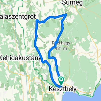
- 67,5 km
- Dystans
- 84 m
- Przewyższenia
- 99 m
- Spadek
- ---
- Śr. Prędkość
- ---
- Maks. wysokość
Najważniejsze punkty trasy
Punkty zainteresowania na trasie
Interesujące miejsce po 2,8 km
Esőbeálló, pihenőhely
Interesujące miejsce po 4,7 km
Esőbeálló, pihenőhely
Interesujące miejsce po 6,1 km
Esőbeálló, pihenőhely
Interesujące miejsce po 7,2 km
Esőbeálló, pihenőhely
Interesujące miejsce po 8,6 km
Esőbeálló, pihenőhely
Interesujące miejsce po 10 km
Esőbeálló, pihenőhely
Interesujące miejsce po 11,3 km
Esőbeálló, pihenőhely
Interesujące miejsce po 12,5 km
Esőbeálló, pihenőhely
Interesujące miejsce po 14,2 km
Esőbeálló, pihenőhely
Interesujące miejsce po 61,5 km
Esőbeálló, pihenőhely
Interesujące miejsce po 62,6 km
Esőbeálló, pihenőhely
Interesujące miejsce po 63,7 km
Esőbeálló, pihenőhely
Interesujące miejsce po 65,2 km
Esőbeálló, pihenőhely
Interesujące miejsce po 65,7 km
Esőbeálló, pihenőhely
Interesujące miejsce po 67,4 km
Esőbeálló, pihenőhely
Kontynuuj z Bikemap
Użyj, edytuj lub pobierz tę trasę rowerową
Chcesz przejechać trasę Balaton túra C lub dostosować ją do swojej wycieczki? Oto, co możesz zrobić z tą trasą na Bikemap:
Darmowe funkcje
- Zapisz tę trasę jako ulubioną lub w kolekcji
- Skopiuj i zaplanuj swoją wersję tej trasy
- Synchronizuj swoją trasę z Garminem lub Wahoo
Funkcje Premium
3 dni bezpłatnej wersji próbnej lub jednorazowa opłata. Dowiedz się więcej o Bikemap Premium.
- Nawiguj po tej trasie na iOS i Androidzie
- Eksportuj plik GPX / KML tej trasy
- Stwórz swój własny wydruk (wypróbuj za darmo)
- Pobierz tę trasę do nawigacji offline
Odkryj więcej funkcji Premium.
Uzyskaj Bikemap PremiumOd naszej społeczności
Keszthely: Inne popularne trasy rozpoczynające się tutaj
 Balaton Tour A
- Dystans
- 34,5 km
- Przewyższenia
- 41 m
- Spadek
- 41 m
- Lokalizacja
- Keszthely, Komitat Zala, Węgry
 Pipacs utca 55, Keszthely - Pipacs utca 57, Keszthely
- Dystans
- 13,7 km
- Przewyższenia
- 58 m
- Spadek
- 48 m
- Lokalizacja
- Keszthely, Komitat Zala, Węgry
 Keszhely - Veszprém
- Dystans
- 112,4 km
- Przewyższenia
- 448 m
- Spadek
- 284 m
- Lokalizacja
- Keszthely, Komitat Zala, Węgry
 KH - Rezi - Sümegprága - Kisgörbö - Karmacs - KH
- Dystans
- 54,6 km
- Przewyższenia
- 365 m
- Spadek
- 365 m
- Lokalizacja
- Keszthely, Komitat Zala, Węgry
 KH - Rezi - Óhíd - Zalaszentgrót - Sarmelék - KH
- Dystans
- 81,2 km
- Przewyższenia
- 382 m
- Spadek
- 385 m
- Lokalizacja
- Keszthely, Komitat Zala, Węgry
 KIS-BALATON kör
- Dystans
- 77,9 km
- Przewyższenia
- 370 m
- Spadek
- 368 m
- Lokalizacja
- Keszthely, Komitat Zala, Węgry
 A piros+ panorámája
- Dystans
- 26,9 km
- Przewyższenia
- 385 m
- Spadek
- 392 m
- Lokalizacja
- Keszthely, Komitat Zala, Węgry
 keszthely
- Dystans
- 38,3 km
- Przewyższenia
- 122 m
- Spadek
- 134 m
- Lokalizacja
- Keszthely, Komitat Zala, Węgry
Otwórz ją w aplikacji