

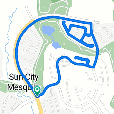
Sun City Bike Club Easy Ride 1 Out and Back Around Mesquite and Bunkerville
Trasa rowerowa rozpoczynająca się w Mesquite, Nevada, USA.
Przegląd
O tej trasie
This is a fairly flat and easy out and back ride from Sun City Mesquite. The ride starts with a mostly downhill ride to Sunset Greens; a slight uphill ride to Riverside Road (NV 170); a slight up and down ride to and through Bunkerville and back to Hafen Lane; a relatively flat ride back through the two roundabouts and passed West Pioneer Boulevard; then a pretty good climb to the finish. Total Ride Distance: 19.4 Miles.
Notes: 1. If you open the route in Google Roadmap or Google Hybrid (pulled down from the "Relief Map" tab) you will get a more up-to-date view of the roads and paths. Some of the other maps are dated. 2. Riverside Road can be ridden either on a pedestrian/bike path (shown on the map) or on the roadway itself. There is some traffic, particularly heading from Bunkerville back into Mesquite. 3. Part of the ride within the city of Mesquite is also on a separate pedestrian/bike path (shown on the map) starting off of Hafen Lane and ending at Old Mill Road. 4. This mapping program tends to under-compute the total ride mileage by roughly 10%, based on mileage for this ride when it has been actually ridden. - -:--
- Czas
- 31,3 km
- Dystans
- 116 m
- Przewyższenia
- 117 m
- Spadek
- ---
- Śr. Prędkość
- ---
- Maks. wysokość
Jakość trasy
Typy dróg i nawierzchnie na trasie
Typy dróg
Droga rowerowa
9,4 km
(30 %)
Spokojna droga
6,9 km
(22 %)
Powierzchnie
Utwardzona
22,8 km
(73 %)
Asfalt
17,8 km
(57 %)
Beton
4,4 km
(14 %)
Kontynuuj z Bikemap
Użyj, edytuj lub pobierz tę trasę rowerową
Chcesz przejechać trasę Sun City Bike Club Easy Ride 1 Out and Back Around Mesquite and Bunkerville lub dostosować ją do swojej wycieczki? Oto, co możesz zrobić z tą trasą na Bikemap:
Darmowe funkcje
- Zapisz tę trasę jako ulubioną lub w kolekcji
- Skopiuj i zaplanuj swoją wersję tej trasy
- Synchronizuj swoją trasę z Garminem lub Wahoo
Funkcje Premium
3 dni bezpłatnej wersji próbnej lub jednorazowa opłata. Dowiedz się więcej o Bikemap Premium.
- Nawiguj po tej trasie na iOS i Androidzie
- Eksportuj plik GPX / KML tej trasy
- Stwórz swój własny wydruk (wypróbuj za darmo)
- Pobierz tę trasę do nawigacji offline
Odkryj więcej funkcji Premium.
Uzyskaj Bikemap PremiumOd naszej społeczności
Mesquite: Inne popularne trasy rozpoczynające się tutaj
 870 Deep Gorge Trail, Mesquite to 1350 Flat Top Mesa Dr, Mesquite
- Dystans
- 27,3 km
- Przewyższenia
- 281 m
- Spadek
- 243 m
- Lokalizacja
- Mesquite, Nevada, USA
 Settlers Way, Mesquite to 1350 Flat Top Mesa Dr, Mesquite
- Dystans
- 15,1 km
- Przewyższenia
- 232 m
- Spadek
- 194 m
- Lokalizacja
- Mesquite, Nevada, USA
 1350 Flat Top Mesa Dr, Mesquite to 1173 Clouds Rest Pt, Mesquite
- Dystans
- 0,9 km
- Przewyższenia
- 21 m
- Spadek
- 32 m
- Lokalizacja
- Mesquite, Nevada, USA
 Mesquite, NV - Mount Charleston, NV
- Dystans
- 182,8 km
- Przewyższenia
- 2261 m
- Spadek
- 464 m
- Lokalizacja
- Mesquite, Nevada, USA
 Sun City Bike Club Easy Ride 4 (Wagon Wheel, Overland Trail and Frontier Pass Neighborhoods)
- Dystans
- 5 km
- Przewyższenia
- 91 m
- Spadek
- 89 m
- Lokalizacja
- Mesquite, Nevada, USA
 Sun City Bike Club Easy Ride 3 (Tannery Cove)
- Dystans
- 4,5 km
- Przewyższenia
- 114 m
- Spadek
- 114 m
- Lokalizacja
- Mesquite, Nevada, USA
 Recovered Route
- Dystans
- 12,1 km
- Przewyższenia
- 278 m
- Spadek
- 231 m
- Lokalizacja
- Mesquite, Nevada, USA
 Crescent Moon Crossing 830, Mesquite to Crescent Moon Bend 829, Mesquite
- Dystans
- 3,4 km
- Przewyższenia
- 44 m
- Spadek
- 45 m
- Lokalizacja
- Mesquite, Nevada, USA
Otwórz ją w aplikacji