
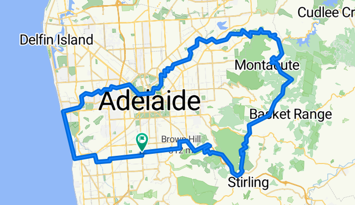
mt lofty loop 1
Trasa rowerowa rozpoczynająca się w Clarence Gardens, State of South Australia, Australia.
Przegląd
O tej trasie
This route is approximately 100km and takes in the best of the hills, Torrens linear park, and the beach.
This loop is best done in the anti-clockwise direction, as it makes use of the Adelaide-Crafers bikeway to climb up to Mt Lofty. Take a break at the Lofty summit to celebrate the climb. The rest of the ride is pretty easy.
Watch out for Corkscrew Rd coming down from Montacute Rd at Montacute to Gorge Rd at Castambul. It is VERY steep. Good breaks required. Lots of fun.
This loop has very low car traffic - over 50% is on bike path. Take care on Cross Rd at Glen Osmond and Gorge Rd at Castambul. You'll be able to get off Gorge Rd after just a couple of km as the Torrens linear park starts near there.
check connection between top of crafers bikeway and mt lofty summmit rd. sattelite maps not working.
Check bike paths in Glenelg area.
- -:--
- Czas
- 90,9 km
- Dystans
- 736 m
- Przewyższenia
- 736 m
- Spadek
- ---
- Śr. Prędkość
- ---
- Maks. wysokość
Kontynuuj z Bikemap
Użyj, edytuj lub pobierz tę trasę rowerową
Chcesz przejechać trasę mt lofty loop 1 lub dostosować ją do swojej wycieczki? Oto, co możesz zrobić z tą trasą na Bikemap:
Darmowe funkcje
- Zapisz tę trasę jako ulubioną lub w kolekcji
- Skopiuj i zaplanuj swoją wersję tej trasy
- Podziel trasę na etapy, aby utworzyć kilkudniową wycieczkę
- Synchronizuj swoją trasę z Garminem lub Wahoo
Funkcje Premium
3 dni bezpłatnej wersji próbnej lub jednorazowa opłata. Dowiedz się więcej o Bikemap Premium.
- Nawiguj po tej trasie na iOS i Androidzie
- Eksportuj plik GPX / KML tej trasy
- Stwórz swój własny wydruk (wypróbuj za darmo)
- Pobierz tę trasę do nawigacji offline
Odkryj więcej funkcji Premium.
Uzyskaj Bikemap PremiumOd naszej społeczności
Clarence Gardens: Inne popularne trasy rozpoczynające się tutaj
 bike tour from Melrose Park to St Marys
- Dystans
- 20,6 km
- Przewyższenia
- 34 m
- Spadek
- 36 m
- Lokalizacja
- Clarence Gardens, State of South Australia, Australia
 East Ave, Clarence Park to Frederick St, Clarence Park
- Dystans
- 18,9 km
- Przewyższenia
- 75 m
- Spadek
- 82 m
- Lokalizacja
- Clarence Gardens, State of South Australia, Australia
 Slow ride in Daw Park
- Dystans
- 2,1 km
- Przewyższenia
- 0 m
- Spadek
- 0 m
- Lokalizacja
- Clarence Gardens, State of South Australia, Australia
 oct8th
- Dystans
- 154,6 km
- Przewyższenia
- 80 m
- Spadek
- 147 m
- Lokalizacja
- Clarence Gardens, State of South Australia, Australia
 mt lofty loop 1
- Dystans
- 90,9 km
- Przewyższenia
- 736 m
- Spadek
- 736 m
- Lokalizacja
- Clarence Gardens, State of South Australia, Australia
 18 De Laine Avenue, Edwardstown to 20 Wattle Street, Campbelltown
- Dystans
- 16,1 km
- Przewyższenia
- 73 m
- Spadek
- 30 m
- Lokalizacja
- Clarence Gardens, State of South Australia, Australia
 Final 3 Peaks training route
- Dystans
- 296 km
- Przewyższenia
- 2089 m
- Spadek
- 2089 m
- Lokalizacja
- Clarence Gardens, State of South Australia, Australia
 Random lengthy ride CLONED FROM ROUTE 1443430
- Dystans
- 42 km
- Przewyższenia
- 702 m
- Spadek
- 696 m
- Lokalizacja
- Clarence Gardens, State of South Australia, Australia
Otwórz ją w aplikacji