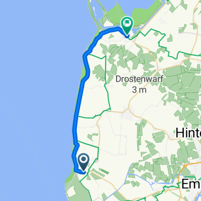
Von Rysum nach Greetsiel
- 25,4 km
- 10 m
- 13 m
- Hinte, Dolna Saksonia, Niemcy
Trasa rowerowa rozpoczynająca się w Hinte, Dolna Saksonia, Niemcy.
Przegląd
Od Rysum do Greetsiel
W Rysum rozpoczyna się wycieczka. Kościół w centrum Rysum warto najpierw odwiedzić. Znajduje się tam jeden z najstarszych działających organów w Europie. Poza tym Rysum jest jedną z najpiękniejszych wsi w regionie, zdobywcą tytułu krajowego w konkursie „Nasza wieś ma być piękniejsza”. Tuż obok kościoła znajduje się młyn, który został odbudowany przez nienaruszoną społeczność wiejską. Można nie tylko napić się pysznej herbaty z Ostfriesland, ale także nocować w małych grupach. Wycieczka prowadzi wzdłuż „Gasthof im Gulfhof” i tradycyjnej tawerny na rynku dalej do osady grodziskowej Loquard, byłej siedziby wodza. Centrum Loquard zostało całkowicie „odnowione” i oferuje wiele idyllicznych miejsc do zatrzymania się. Następnie mija się pomnik przyrody „Appeltuun” w stronę Campen. Warto odwiedzić tutaj muzeum rolnictwa i latarnię morską Campen. Konstrukcja stalowa latarni jest oszałamiająca i przypomina nieco Wieżę Eiffla w Paryżu. Po 320 schodach dociera się na szczyt latarni i można podziwiać wspaniałą panoramę. Po chwili odpoczynku kontynuuje się jazdę do Upleward wzdłuż wału na suchą plażę. Następnie wycieczka prowadzi dalej do Hamswehrum. Z Hamswehrum to tylko rzut kamieniem do Groothusen. Warto odwiedzić potężny kościół. Przez idylliczny rdzeń wsi kontynuuje się wzdłuż imponującego Osterburga do Manslagt. Jak w prawie każdej wiosce, znajduje się również tutaj tablica informacyjna zawierająca wszystko, co warto wiedzieć. Z Manslagt następnie jedzie się do Pilsum, wioski muzyki. Już z daleka widać dużą kościół krzyżowy z cegły. Także tutaj warto odwiedzić kościół. Z Pilsum do wału do Diekskiel, a następnie wzdłuż wału do najmniejszej, ale prawdopodobnie najbardziej znanej latarni morskiej w Niemczech, latarni morskiej Pilsum. Mijając Park Narodowy Wadden, przechodzi się przez teren ochrony ptaków do Greetsiel. Ta idylliczna wioska rybacka zaprasza do zakończenia dnia przytulnym wieczorem.
utworzono 16 lat temu temu
Jakość trasy
Droga leśna
8,6 km
(34 %)
Spokojna droga
7,1 km
(28 %)
Utwardzona
19,8 km
(78 %)
Nieutwardzona
0,5 km
(2 %)
Asfalt
16,3 km
(64 %)
Beton
3,6 km
(14 %)
Kontynuuj z Bikemap
Chcesz przejechać trasę Von Rysum nach Greetsiel lub dostosować ją do swojej wycieczki? Oto, co możesz zrobić z tą trasą na Bikemap:
3 dni bezpłatnej wersji próbnej lub jednorazowa opłata. Dowiedz się więcej o Bikemap Premium.
Odkryj więcej funkcji Premium.
Uzyskaj Bikemap PremiumOd naszej społeczności
Otwórz ją w aplikacji