

Gherla - Stancile Niculii
Trasa rowerowa rozpoczynająca się w Gherla, Okręg Kluż, Rumunia.
Przegląd
O tej trasie
Traseu usor pana se termina soseaua spre satul Nicula ,Intrarea pe urcusul spre Stancile Niculii este foarte grea,va trebuie ceva tehnica de mers in zig-zag daca nu , nu pute-ti urca .Noroc .
- -:--
- Czas
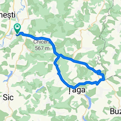
- 3,7 km
- Dystans
- 26 m
- Przewyższenia
- 4 m
- Spadek
- ---
- Śr. Prędkość
- 275 m
- Maks. wysokość

Jakość trasy
Typy dróg i nawierzchnie na trasie
Powierzchnie
Utwardzona
3,7 km
(100 %)
Asfalt
3,7 km
(100 %)
Najważniejsze punkty trasy
Punkty zainteresowania na trasie

Interesujące miejsce po 1,7 km
vedere cariera de la fabrica de caramida

Interesujące miejsce po 3,1 km
panorama superba cand o sa prinde-ti ceata de dimineata

Interesujące miejsce po 3,2 km
sat Nicula

Interesujące miejsce po 3,3 km
Panorama superba daca nu pride-ti ceata ca deobicei .Se vede varful de 400 m amintit in turele anterioare.

Interesujące miejsce po 3,7 km
Stancile Niculii
Kontynuuj z Bikemap
Użyj, edytuj lub pobierz tę trasę rowerową
Chcesz przejechać trasę Gherla - Stancile Niculii lub dostosować ją do swojej wycieczki? Oto, co możesz zrobić z tą trasą na Bikemap:
Darmowe funkcje
- Zapisz tę trasę jako ulubioną lub w kolekcji
- Skopiuj i zaplanuj swoją wersję tej trasy
- Synchronizuj swoją trasę z Garminem lub Wahoo
Funkcje Premium
3 dni bezpłatnej wersji próbnej lub jednorazowa opłata. Dowiedz się więcej o Bikemap Premium.
- Nawiguj po tej trasie na iOS i Androidzie
- Eksportuj plik GPX / KML tej trasy
- Stwórz swój własny wydruk (wypróbuj za darmo)
- Pobierz tę trasę do nawigacji offline
Odkryj więcej funkcji Premium.
Uzyskaj Bikemap PremiumOd naszej społeczności
Gherla: Inne popularne trasy rozpoczynające się tutaj
 Tura Uphill extreme
- Dystans
- 11,2 km
- Przewyższenia
- 258 m
- Spadek
- 257 m
- Lokalizacja
- Gherla, Okręg Kluż, Rumunia
 MTB Fizes-Padureni-Gherla(don't try this if your not sure about route)
- Dystans
- 21 km
- Przewyższenia
- 307 m
- Spadek
- 306 m
- Lokalizacja
- Gherla, Okręg Kluż, Rumunia
 Gherla-Pintic-Ocna-Gherla
- Dystans
- 39,7 km
- Przewyższenia
- 361 m
- Spadek
- 360 m
- Lokalizacja
- Gherla, Okręg Kluż, Rumunia
 Turul balonului
- Dystans
- 42,5 km
- Przewyższenia
- 255 m
- Spadek
- 256 m
- Lokalizacja
- Gherla, Okręg Kluż, Rumunia
 Route of nature 5
- Dystans
- 5,1 km
- Przewyższenia
- 146 m
- Spadek
- 15 m
- Lokalizacja
- Gherla, Okręg Kluż, Rumunia
 " Salt territories "
- Dystans
- 17,7 km
- Przewyższenia
- 98 m
- Spadek
- 97 m
- Lokalizacja
- Gherla, Okręg Kluż, Rumunia
 Green landscape route
- Dystans
- 11,4 km
- Przewyższenia
- 166 m
- Spadek
- 165 m
- Lokalizacja
- Gherla, Okręg Kluż, Rumunia
 MTB langa padurea Morii
- Dystans
- 2,6 km
- Przewyższenia
- 52 m
- Spadek
- 13 m
- Lokalizacja
- Gherla, Okręg Kluż, Rumunia
Otwórz ją w aplikacji