

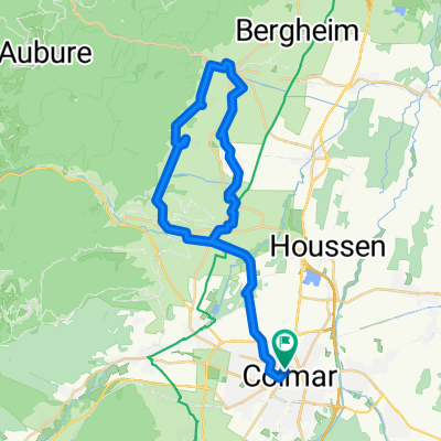
Classique des Vogés
Trasa rowerowa rozpoczynająca się w Colmar, Grand Est, Francja.
Przegląd
O tej trasie
Vogeserne Classic
Firstplan - Petit Ballon - Platzerwaesel - Grand Ballon (Col du Haag) - Bramont - Croix des Moinats - Ménil - Col des Croix - Ballon de Servance - Planche Belles Filles
- -:--
- Czas
- 209,1 km
- Dystans
- 4428 m
- Przewyższenia
- 3601 m
- Spadek
- ---
- Śr. Prędkość
- ---
- Maks. wysokość

Jakość trasy
Typy dróg i nawierzchnie na trasie
Typy dróg
Droga
73,2 km
(35 %)
Spokojna droga
62,7 km
(30 %)
Powierzchnie
Utwardzona
98,3 km
(47 %)
Nieutwardzona
6,3 km
(3 %)
Asfalt
98,3 km
(47 %)
Nieutwardzony (nieokreślony)
2,1 km
(1 %)
Najważniejsze punkty trasy
Punkty zainteresowania na trasie
Interesujące miejsce po 25,6 km
Col du Firstplan
Interesujące miejsce po 42,7 km
Col de Petit Ballon
Interesujące miejsce po 58,6 km
Col du Platzerwaesel
Interesujące miejsce po 101,7 km
Col du Haag
Interesujące miejsce po 103,3 km
Grand Ballon
Interesujące miejsce po 133,7 km
Col d'Oderen
Interesujące miejsce po 144,7 km
Col de Bramont
Interesujące miejsce po 153 km
Col de Grosse Pierre
Interesujące miejsce po 159,6 km
Col de la Croix des Moinats
Interesujące miejsce po 159,8 km
Col de Menufosse
Interesujące miejsce po 160,5 km
Col des Hayes
Interesujące miejsce po 170,1 km
Col du Ménil
Interesujące miejsce po 182,1 km
Col des Croix
Interesujące miejsce po 192,4 km
Ballon de Servance
Interesujące miejsce po 209,1 km
Belles Filles
Kontynuuj z Bikemap
Użyj, edytuj lub pobierz tę trasę rowerową
Chcesz przejechać trasę Classique des Vogés lub dostosować ją do swojej wycieczki? Oto, co możesz zrobić z tą trasą na Bikemap:
Darmowe funkcje
- Zapisz tę trasę jako ulubioną lub w kolekcji
- Skopiuj i zaplanuj swoją wersję tej trasy
- Podziel trasę na etapy, aby utworzyć kilkudniową wycieczkę
- Synchronizuj swoją trasę z Garminem lub Wahoo
Funkcje Premium
3 dni bezpłatnej wersji próbnej lub jednorazowa opłata. Dowiedz się więcej o Bikemap Premium.
- Nawiguj po tej trasie na iOS i Androidzie
- Eksportuj plik GPX / KML tej trasy
- Stwórz swój własny wydruk (wypróbuj za darmo)
- Pobierz tę trasę do nawigacji offline
Odkryj więcej funkcji Premium.
Uzyskaj Bikemap PremiumOd naszej społeczności
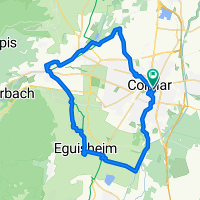
Colmar: Inne popularne trasy rozpoczynające się tutaj
 Etappe 14 Tour de France 2009 von Colmar nach Besançon
- Dystans
- 202,5 km
- Przewyższenia
- 1131 m
- Spadek
- 1003 m
- Lokalizacja
- Colmar, Grand Est, Francja
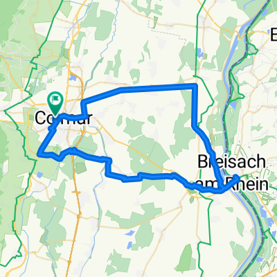
 Golmar
- Dystans
- 48,2 km
- Przewyższenia
- 684 m
- Spadek
- 685 m
- Lokalizacja
- Colmar, Grand Est, Francja
 Girolibero: Colmar e l'Alsazia
- Dystans
- 363,1 km
- Przewyższenia
- 715 m
- Spadek
- 717 m
- Lokalizacja
- Colmar, Grand Est, Francja
 Tag4 Colmar - Kaysersberg
- Dystans
- 13 km
- Przewyższenia
- 78 m
- Spadek
- 13 m
- Lokalizacja
- Colmar, Grand Est, Francja
 Rue du Chasseur to Place Jeanne d'Arc
- Dystans
- 28,7 km
- Przewyższenia
- 107 m
- Spadek
- 108 m
- Lokalizacja
- Colmar, Grand Est, Francja
 Classique des Vogés
- Dystans
- 209,1 km
- Przewyższenia
- 4428 m
- Spadek
- 3601 m
- Lokalizacja
- Colmar, Grand Est, Francja
 Rue Saint-Léon, Colmar à Rue Saint-Léon, Colmar
- Dystans
- 59,8 km
- Przewyższenia
- 132 m
- Spadek
- 134 m
- Lokalizacja
- Colmar, Grand Est, Francja
 Rue du Rempart, Colmar to Rue du Rempart, Colmar
- Dystans
- 38,8 km
- Przewyższenia
- 409 m
- Spadek
- 410 m
- Lokalizacja
- Colmar, Grand Est, Francja
Otwórz ją w aplikacji