Chaumont
Trasa rowerowa rozpoczynająca się w Le Landeron, Canton of Neuchâtel, Switzerland.
Przegląd
O tej trasie
Auf den Chaumont
- -:--
- Czas
- 36,9 km
- Dystans
- 828 m
- Przewyższenia
- 827 m
- Spadek
- ---
- Śr. Prędkość
- ---
- Maks. wysokość
Kontynuuj z Bikemap
Użyj, edytuj lub pobierz tę trasę rowerową
Chcesz przejechać trasę Chaumont lub dostosować ją do swojej wycieczki? Oto, co możesz zrobić z tą trasą na Bikemap:
Darmowe funkcje
- Zapisz tę trasę jako ulubioną lub w kolekcji
- Skopiuj i zaplanuj swoją wersję tej trasy
- Synchronizuj swoją trasę z Garminem lub Wahoo
Funkcje Premium
3 dni bezpłatnej wersji próbnej lub jednorazowa opłata. Dowiedz się więcej o Bikemap Premium.
- Nawiguj po tej trasie na iOS i Androidzie
- Eksportuj plik GPX / KML tej trasy
- Stwórz swój własny wydruk (wypróbuj za darmo)
- Pobierz tę trasę do nawigacji offline
Odkryj więcej funkcji Premium.
Uzyskaj Bikemap PremiumOd naszej społeczności
Le Landeron: Inne popularne trasy rozpoczynające się tutaj
- Landeron-Chasseral
- Dystans
- 14,6 km
- Przewyższenia
- 1075 m
- Spadek
- 5 m
- Lokalizacja
- Le Landeron, Canton of Neuchâtel, Switzerland
- Le Landeron-Chaumont-Hauterive-Les Fourches-Le Landeron
- Dystans
- 44,1 km
- Przewyższenia
- 977 m
- Spadek
- 978 m
- Lokalizacja
- Le Landeron, Canton of Neuchâtel, Switzerland
- Cressier to Bern
- Dystans
- 52,1 km
- Przewyższenia
- 324 m
- Spadek
- 243 m
- Lokalizacja
- Le Landeron, Canton of Neuchâtel, Switzerland
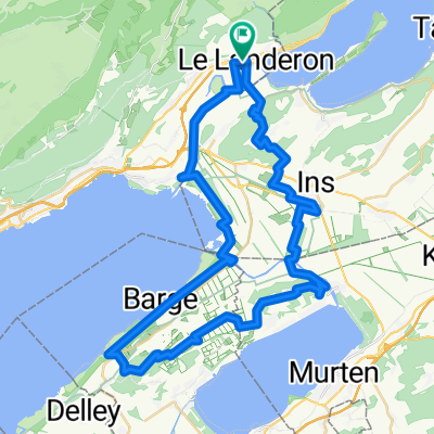
- Itinéraire confortable en Le Landeron
- Dystans
- 13,3 km
- Przewyższenia
- 181 m
- Spadek
- 175 m
- Lokalizacja
- Le Landeron, Canton of Neuchâtel, Switzerland
- Chasseral Oh yeah!
- Dystans
- 55,1 km
- Przewyższenia
- 1174 m
- Spadek
- 1176 m
- Lokalizacja
- Le Landeron, Canton of Neuchâtel, Switzerland
- Le Landeron-Les Fourches-Jolimont-Lüscherz-Le Landeron
- Dystans
- 48,6 km
- Przewyższenia
- 772 m
- Spadek
- 774 m
- Lokalizacja
- Le Landeron, Canton of Neuchâtel, Switzerland
- LanderonVully
- Dystans
- 41,4 km
- Przewyższenia
- 276 m
- Spadek
- 276 m
- Lokalizacja
- Le Landeron, Canton of Neuchâtel, Switzerland
- Bieler See Rundfahrt
- Dystans
- 40 km
- Przewyższenia
- 155 m
- Spadek
- 148 m
- Lokalizacja
- Le Landeron, Canton of Neuchâtel, Switzerland
Otwórz ją w aplikacji