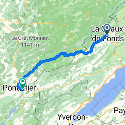
La Chaux-de-Fonds towards Lake Neuchatel and back
Trasa rowerowa rozpoczynająca się w La Chaux-de-Fonds, Neuchâtel, Szwajcaria.
Przegląd
O tej trasie
Sweet two hour ride with a spectacular descent down La Tournee, followed by a traverse across the Val de Ruz. The climb from Chezard St Martin is over 10% and on a quiet forested road. From the top of this climb, the route follows the tranquil high mountain valley of the Grand Combe, where you will barely see a soul (the road surface is a bit rough but is tarmac). After the descent to where the mountain tunnel briefly passes pops out of the mountain, there's a 15% climb before rolling back into La Chaux.
- -:--
- Czas
- 57,9 km
- Dystans
- 1062 m
- Przewyższenia
- 1062 m
- Spadek
- ---
- Śr. Prędkość
- ---
- Maks. wysokość
Jakość trasy
Typy dróg i nawierzchnie na trasie
Typy dróg
Spokojna droga
22,4 km
(39 %)
Droga
20,2 km
(35 %)
Powierzchnie
Utwardzona
23,2 km
(40 %)
Nieutwardzona
0,1 km
(<1 %)
Asfalt
20,1 km
(35 %)
Beton
3 km
(5 %)
Kontynuuj z Bikemap
Użyj, edytuj lub pobierz tę trasę rowerową
Chcesz przejechać trasę La Chaux-de-Fonds towards Lake Neuchatel and back lub dostosować ją do swojej wycieczki? Oto, co możesz zrobić z tą trasą na Bikemap:
Darmowe funkcje
- Zapisz tę trasę jako ulubioną lub w kolekcji
- Skopiuj i zaplanuj swoją wersję tej trasy
- Synchronizuj swoją trasę z Garminem lub Wahoo
Funkcje Premium
3 dni bezpłatnej wersji próbnej lub jednorazowa opłata. Dowiedz się więcej o Bikemap Premium.
- Nawiguj po tej trasie na iOS i Androidzie
- Eksportuj plik GPX / KML tej trasy
- Stwórz swój własny wydruk (wypróbuj za darmo)
- Pobierz tę trasę do nawigacji offline
Odkryj więcej funkcji Premium.
Uzyskaj Bikemap PremiumOd naszej społeczności
La Chaux-de-Fonds: Inne popularne trasy rozpoczynające się tutaj
- la Ferrière
- Dystans
- 28,7 km
- Przewyższenia
- 519 m
- Spadek
- 515 m
- Lokalizacja
- La Chaux-de-Fonds, Neuchâtel, Szwajcaria
- VTT Pouillerel 16Km (1h30)
- Dystans
- 16,1 km
- Przewyższenia
- 326 m
- Spadek
- 327 m
- Lokalizacja
- La Chaux-de-Fonds, Neuchâtel, Szwajcaria
- Doubs
- Dystans
- 38 km
- Przewyższenia
- 871 m
- Spadek
- 871 m
- Lokalizacja
- La Chaux-de-Fonds, Neuchâtel, Szwajcaria
- Le Chaux-de-Fonds-Pré Petitjean
- Dystans
- 50,6 km
- Przewyższenia
- 813 m
- Spadek
- 819 m
- Lokalizacja
- La Chaux-de-Fonds, Neuchâtel, Szwajcaria
- La Chaux-de-Fonds - St Croix
- Dystans
- 111,5 km
- Przewyższenia
- 1316 m
- Spadek
- 1316 m
- Lokalizacja
- La Chaux-de-Fonds, Neuchâtel, Szwajcaria
- La Chaux-de-Fonds - Tramelan - (Bern Auto)
- Dystans
- 106,8 km
- Przewyższenia
- 660 m
- Spadek
- 1192 m
- Lokalizacja
- La Chaux-de-Fonds, Neuchâtel, Szwajcaria
- Doubs Rundtour Juni 2023
- Dystans
- 152,2 km
- Przewyższenia
- 3637 m
- Spadek
- 3638 m
- Lokalizacja
- La Chaux-de-Fonds, Neuchâtel, Szwajcaria
- La Chaux-de-Fonds to Porrentruy
- Dystans
- 81,2 km
- Przewyższenia
- 1431 m
- Spadek
- 1997 m
- Lokalizacja
- La Chaux-de-Fonds, Neuchâtel, Szwajcaria
Otwórz ją w aplikacji