

A Coffee + Architecture + Platting + Infrastructure + Beer Exploration
Trasa rowerowa rozpoczynająca się w Portland, Oregon, USA.
Przegląd
O tej trasie
Rzeczy, które zobaczymy/zrobimy.
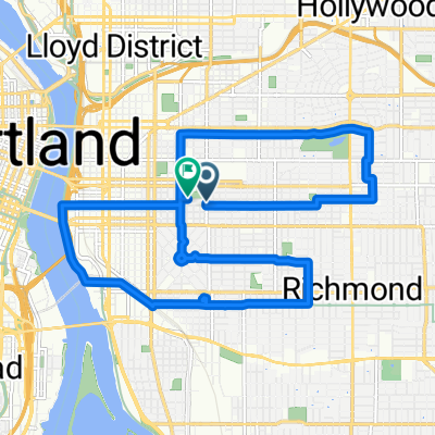
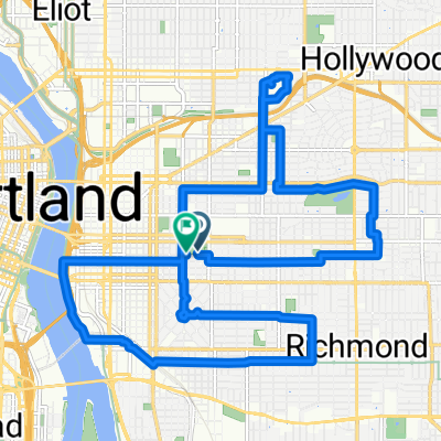
Przejedziemy przez Steel Bridge - 104-letni most, który obsługuje tramwaje, autobusy, pieszych, rowery, torfowiska, pociągi pasażerskie i także ciągniki. To koń roboczy Portland od 1912 roku!
Cup & Bar - jedna z najnowszych palarni w mieście, dostarcza za pomocą roweru towarowego, z otwartą przestrzenią do odpoczynku/hakowania/jeżdżenia na rowerze itp. Położona obok dwóch nowych zwariowanych wieżowców mieszkalnych, które się budują.
Ladd's Addition, jedna z pierwszych dzielnic, zaplanowana dzielnica tramwajowa w Portland, zaprojektowana i zbudowana w latach 1905-1930.
Apex Bar/Browarnia. Niesamowity bar z rockowymi utworami, więcej miejsc na rowery, niż można sobie wyobrazić (a i tak prawdopodobnie zablokujemy do drzew) oraz niezwykle imponująca selekcja piw lokalnych (dziesiątki i dziesiątki z nich!).
Tillikum Bridge to nowy most transportowy, rowerowy i pieszy w Portland. Pokonamy niektóre z nowych MUP (Mixed Use Path) w stronę mostu, gdzie będziesz mógł zobaczyć zbiegu tramwajów, tramwajów lekkich i autobusów na moście, i prawdopodobnie cyklistów i pieszych wszędzie. To sprytny most, otwarty w zeszłym roku we wrześniu!
Wrócimy wzdłuż południowego końca MUP (Mixed Use Path) nabrzeża.
- -:--
- Czas
- 9,9 km
- Dystans
- 122 m
- Przewyższenia
- 121 m
- Spadek
- ---
- Śr. Prędkość
- ---
- Maks. wysokość

Jakość trasy
Typy dróg i nawierzchnie na trasie
Typy dróg
Spokojna droga
3,6 km
(36 %)
Droga rowerowa
2,7 km
(27 %)
Powierzchnie
Utwardzona
8,6 km
(87 %)
Asfalt
3,9 km
(39 %)
Nawierzchnia (nieokreślona)
2,4 km
(24 %)
Kontynuuj z Bikemap
Użyj, edytuj lub pobierz tę trasę rowerową
Chcesz przejechać trasę A Coffee + Architecture + Platting + Infrastructure + Beer Exploration lub dostosować ją do swojej wycieczki? Oto, co możesz zrobić z tą trasą na Bikemap:
Darmowe funkcje
- Zapisz tę trasę jako ulubioną lub w kolekcji
- Skopiuj i zaplanuj swoją wersję tej trasy
- Synchronizuj swoją trasę z Garminem lub Wahoo
Funkcje Premium
3 dni bezpłatnej wersji próbnej lub jednorazowa opłata. Dowiedz się więcej o Bikemap Premium.
- Nawiguj po tej trasie na iOS i Androidzie
- Eksportuj plik GPX / KML tej trasy
- Stwórz swój własny wydruk (wypróbuj za darmo)
- Pobierz tę trasę do nawigacji offline
Odkryj więcej funkcji Premium.
Uzyskaj Bikemap PremiumOd naszej społeczności
Portland: Inne popularne trasy rozpoczynające się tutaj
 50mi loop to troutdale
- Dystans
- 75,9 km
- Przewyższenia
- 278 m
- Spadek
- 274 m
- Lokalizacja
- Portland, Oregon, USA
 august: a taylor swift ride v1
- Dystans
- 15,4 km
- Przewyższenia
- 98 m
- Spadek
- 103 m
- Lokalizacja
- Portland, Oregon, USA
 august: a taylor swift ride v2
- Dystans
- 18,9 km
- Przewyższenia
- 116 m
- Spadek
- 121 m
- Lokalizacja
- Portland, Oregon, USA
 Wednesday 9/24
- Dystans
- 37,7 km
- Przewyższenia
- 225 m
- Spadek
- 187 m
- Lokalizacja
- Portland, Oregon, USA
 I-5 to 205 Loop
- Dystans
- 38,7 km
- Przewyższenia
- 178 m
- Spadek
- 180 m
- Lokalizacja
- Portland, Oregon, USA
 Waterfront 8/9/17
- Dystans
- 17 km
- Przewyższenia
- 131 m
- Spadek
- 133 m
- Lokalizacja
- Portland, Oregon, USA
 8/2017 Century Plus Route 1
- Dystans
- 177,9 km
- Przewyższenia
- 995 m
- Spadek
- 993 m
- Lokalizacja
- Portland, Oregon, USA
 Ride to Rhody
- Dystans
- 89 km
- Przewyższenia
- 1095 m
- Spadek
- 444 m
- Lokalizacja
- Portland, Oregon, USA
Otwórz ją w aplikacji