

Ride along the edge
Trasa rowerowa rozpoczynająca się w Shorewood Hills, Wisconsin, USA.
Przegląd
O tej trasie
To jest przykładowy tekst. To jest przykładowy tekst. To jest przykładowy tekst. To jest przykładowy tekst. To jest przykładowy tekst. To jest przykładowy tekst. To jest przykładowy tekst. To jest przykładowy tekst. To jest przykładowy tekst. To jest przykładowy tekst. To jest przykładowy tekst. To jest przykładowy tekst. To jest przykładowy tekst. To jest przykładowy tekst. To jest przykładowy tekst. To jest przykładowy tekst. To jest przykładowy tekst. To jest przykładowy tekst. To jest przykładowy tekst. To jest przykładowy tekst. To jest przykładowy tekst. To jest przykładowy tekst. To jest przykładowy tekst. To jest przykładowy tekst.
- -:--
- Czas
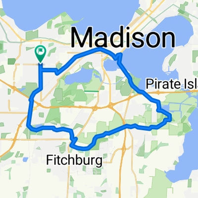
- 4,8 km
- Dystans
- 23 m
- Przewyższenia
- 54 m
- Spadek
- ---
- Śr. Prędkość
- ---
- Maks. wysokość
Zdjęcia trasy


Jakość trasy
Typy dróg i nawierzchnie na trasie
Typy dróg
Spokojna droga
4,7 km
(97 %)
Droga
0,1 km
(2 %)
Droga rowerowa
0 km
(1 %)
Powierzchnie
Utwardzona
3,3 km
(68 %)
Nawierzchnia (nieokreślona)
3,3 km
(68 %)
Niezdefiniowany
1,5 km
(32 %)
Kontynuuj z Bikemap
Użyj, edytuj lub pobierz tę trasę rowerową
Chcesz przejechać trasę Ride along the edge lub dostosować ją do swojej wycieczki? Oto, co możesz zrobić z tą trasą na Bikemap:
Darmowe funkcje
- Zapisz tę trasę jako ulubioną lub w kolekcji
- Skopiuj i zaplanuj swoją wersję tej trasy
- Synchronizuj swoją trasę z Garminem lub Wahoo
Funkcje Premium
3 dni bezpłatnej wersji próbnej lub jednorazowa opłata. Dowiedz się więcej o Bikemap Premium.
- Nawiguj po tej trasie na iOS i Androidzie
- Eksportuj plik GPX / KML tej trasy
- Stwórz swój własny wydruk (wypróbuj za darmo)
- Pobierz tę trasę do nawigacji offline
Odkryj więcej funkcji Premium.
Uzyskaj Bikemap PremiumOd naszej społeczności
Shorewood Hills: Inne popularne trasy rozpoczynające się tutaj
 Capital City Trail
- Dystans
- 30,5 km
- Przewyższenia
- 122 m
- Spadek
- 122 m
- Lokalizacja
- Shorewood Hills, Wisconsin, USA
 Cannonball Path Loop
- Dystans
- 19,8 km
- Przewyższenia
- 65 m
- Spadek
- 67 m
- Lokalizacja
- Shorewood Hills, Wisconsin, USA
 Arboretum Loop
- Dystans
- 11 km
- Przewyższenia
- 75 m
- Spadek
- 75 m
- Lokalizacja
- Shorewood Hills, Wisconsin, USA
 cash on beltline
- Dystans
- 20,1 km
- Przewyższenia
- 154 m
- Spadek
- 151 m
- Lokalizacja
- Shorewood Hills, Wisconsin, USA
 loooop
- Dystans
- 17,2 km
- Przewyższenia
- 68 m
- Spadek
- 71 m
- Lokalizacja
- Shorewood Hills, Wisconsin, USA
 Mendota
- Dystans
- 47,2 km
- Przewyższenia
- 165 m
- Spadek
- 157 m
- Lokalizacja
- Shorewood Hills, Wisconsin, USA
 Ride along the edge
- Dystans
- 4,8 km
- Przewyższenia
- 23 m
- Spadek
- 54 m
- Lokalizacja
- Shorewood Hills, Wisconsin, USA
 First 2017 Ride With Gary
- Dystans
- 21,7 km
- Przewyższenia
- 85 m
- Spadek
- 84 m
- Lokalizacja
- Shorewood Hills, Wisconsin, USA
Otwórz ją w aplikacji