
Naramata Routes
N - L - Naramata Leg Warmer - Competitive
Trasa rowerowa rozpoczynająca się w Summerland, Kolumbia Brytyjska, Kanada.
Przegląd
O tej trasie
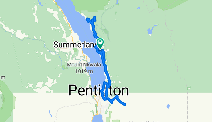
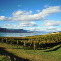
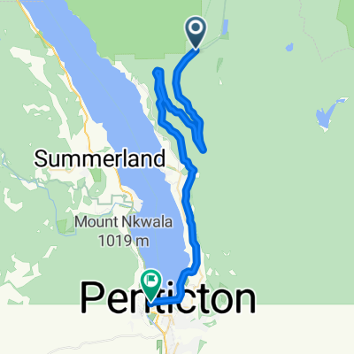
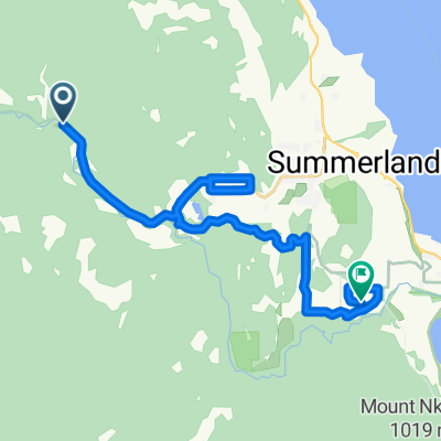
This is a great little leg warming route that just happens to go through one of the most picturesque wine regions in the world - the Naramata Bench. This is a great route for groups of varying abilities, as there are three "out and back" options that allow you to add either km's or climbs. We start from Therapy Vineyards and cruise through sleepy little Naramata before a short climb up to North Naramata Road. Here we head out to Chute Lake Road, the first of our optional climbs. It's a gorgeous climb on fresh pavement to a cattle guard where the gravel starts. We turn back and then decide if we want to do the second option, the descent down to Indian Rock by the lake and the climb back up to the road. We then head back to Naramata for our caffeine refueling break (at 30 km) at either the Grape Leaf Bistro or Cafe Never Matters. Then, back to Naramata Road for a gentle roller ride towards Penticton. We have an optional stop at the Bench for another coffee and snack, then it's the character testing final option - just under 500 M of grueling vertical up Carmi Avenue and Beaverdell Road for an amazing viewpoint of the valley below. Conquer that and it's all downhill to lunch at Lakebreeze Winery and a gentle ride back to Therapy Guesthouse.
If you're opting for less vertical and more wine tasting, we delete the 500M climb and hit a few more winery stops on the way back - notably La Frenz - Red Rooster - and Poplar Grove Cheese and Lock & Smith.
- -:--
- Czas
- 78,8 km
- Dystans
- 1435 m
- Przewyższenia
- 1435 m
- Spadek
- ---
- Śr. Prędkość
- ---
- Maks. wysokość

Część
3 etapy
Jakość trasy
Typy dróg i nawierzchnie na trasie
Typy dróg
Spokojna droga
34,7 km
(44 %)
Droga
24,4 km
(31 %)
Niezdefiniowany
19,7 km
(25 %)
Powierzchnie
Utwardzona
27,6 km
(35 %)
Nieutwardzona
7,1 km
(9 %)
Asfalt
20,5 km
(26 %)
Nawierzchnia (nieokreślona)
7,1 km
(9 %)
Kontynuuj z Bikemap
Użyj, edytuj lub pobierz tę trasę rowerową
Chcesz przejechać trasę N - L - Naramata Leg Warmer - Competitive lub dostosować ją do swojej wycieczki? Oto, co możesz zrobić z tą trasą na Bikemap:
Darmowe funkcje
- Zapisz tę trasę jako ulubioną lub w kolekcji
- Skopiuj i zaplanuj swoją wersję tej trasy
- Synchronizuj swoją trasę z Garminem lub Wahoo
Funkcje Premium
3 dni bezpłatnej wersji próbnej lub jednorazowa opłata. Dowiedz się więcej o Bikemap Premium.
- Nawiguj po tej trasie na iOS i Androidzie
- Eksportuj plik GPX / KML tej trasy
- Stwórz swój własny wydruk (wypróbuj za darmo)
- Pobierz tę trasę do nawigacji offline
Odkryj więcej funkcji Premium.
Uzyskaj Bikemap PremiumOd naszej społeczności
Summerland: Inne popularne trasy rozpoczynające się tutaj
 Glenfir - Naramata - Penticton - Kaleden - OK Falls
- Dystans
- 48,4 km
- Przewyższenia
- 146 m
- Spadek
- 578 m
- Lokalizacja
- Summerland, Kolumbia Brytyjska, Kanada
 2017-07-02 Okanagan Trestle Tour
- Dystans
- 41,7 km
- Przewyższenia
- 57 m
- Spadek
- 902 m
- Lokalizacja
- Summerland, Kolumbia Brytyjska, Kanada
 KVR - Glenfir - Penticton - OK Falls
- Dystans
- 43,5 km
- Przewyższenia
- 143 m
- Spadek
- 607 m
- Lokalizacja
- Summerland, Kolumbia Brytyjska, Kanada
 12-09-14 Kanada: Chute Lake Resort (Kettle Valley Rail Trail)-Penticton
- Dystans
- 39,6 km
- Przewyższenia
- 19 m
- Spadek
- 819 m
- Lokalizacja
- Summerland, Kolumbia Brytyjska, Kanada
 Summerland KVR-TCT
- Dystans
- 21,4 km
- Przewyższenia
- 304 m
- Spadek
- 493 m
- Lokalizacja
- Summerland, Kolumbia Brytyjska, Kanada
 S - S - Bottleneck Drive - Casual
- Dystans
- 29,9 km
- Przewyższenia
- 256 m
- Spadek
- 339 m
- Lokalizacja
- Summerland, Kolumbia Brytyjska, Kanada
 Route in Summerland
- Dystans
- 8 km
- Przewyższenia
- 172 m
- Spadek
- 156 m
- Lokalizacja
- Summerland, Kolumbia Brytyjska, Kanada
 KVR - Summerland to Hope
- Dystans
- 250,4 km
- Przewyższenia
- 1095 m
- Spadek
- 1575 m
- Lokalizacja
- Summerland, Kolumbia Brytyjska, Kanada
Otwórz ją w aplikacji