

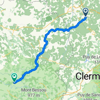
Commentry -- La Villedieu 125km 1420HM
Trasa rowerowa rozpoczynająca się w Commentry, Owernia-Rodan-Alpy, Francja.
Przegląd
O tej trasie
COMMENTRY -- Rue de la Grange --bis Einmündung in D69-- (--oder Variante D69-direkt-von Commentry aus )--Les Brandes des Gouerands -- Durant-Larequilles --D69 -- geht in -- D1089 über --ca 2km vor in Terjat -- D109 --Le Gentioux -- D915 --in Chambonchard -- auf D915--Richtung " Süden" -- Eveaux-les Bains -- D915 -- in Chambon-sur Voueize -- auf D993 -- Lussat -- D55 -- St.Loup auf -- D40 -- geht in St. Julien-le-Chatel in -- D54-über -- in Peyrat-la-Noniere auf --D4-- bei Kreuzung mit D993 --auf D993 -- La Croix de L`Arbres -- D993 -- Montelladonne --Le Courtioux -- St.Amand --D993 bis ca 2km vor Aubusson bei Kreuzung mit D990A -- auf D990A -- Abussson -- "Ausfahrt" -- auf D23 -- Le Pont des Malades-- D23 --umfahren von Filletin -- bei Kreuzung mit D992 -- auf D992 -- Mairie de St. Quentin La Cabanne -- Etang de Vervialle -- Le Chiroux -- D992 --Villemoneix -- Gentioux-Pigerolles -- Faux-La-Montagne --D992 -- LA VILLEDIEUX
- -:--
- Czas
- 125 km
- Dystans
- 1200 m
- Przewyższenia
- 980 m
- Spadek
- ---
- Śr. Prędkość
- ---
- Maks. wysokość
Jakość trasy
Typy dróg i nawierzchnie na trasie
Typy dróg
Ruchliwa droga
75,3 km
(60 %)
Droga
40,9 km
(33 %)
Powierzchnie
Utwardzona
55,4 km
(44 %)
Nieutwardzona
0,1 km
(<1 %)
Asfalt
55,4 km
(44 %)
Nieutwardzony (nieokreślony)
0,1 km
(<1 %)
Niezdefiniowany
69,5 km
(56 %)
Kontynuuj z Bikemap
Użyj, edytuj lub pobierz tę trasę rowerową
Chcesz przejechać trasę Commentry -- La Villedieu 125km 1420HM lub dostosować ją do swojej wycieczki? Oto, co możesz zrobić z tą trasą na Bikemap:
Darmowe funkcje
- Zapisz tę trasę jako ulubioną lub w kolekcji
- Skopiuj i zaplanuj swoją wersję tej trasy
- Podziel trasę na etapy, aby utworzyć kilkudniową wycieczkę
- Synchronizuj swoją trasę z Garminem lub Wahoo
Funkcje Premium
3 dni bezpłatnej wersji próbnej lub jednorazowa opłata. Dowiedz się więcej o Bikemap Premium.
- Nawiguj po tej trasie na iOS i Androidzie
- Eksportuj plik GPX / KML tej trasy
- Stwórz swój własny wydruk (wypróbuj za darmo)
- Pobierz tę trasę do nawigacji offline
Odkryj więcej funkcji Premium.
Uzyskaj Bikemap PremiumOd naszej społeczności
Commentry: Inne popularne trasy rozpoczynające się tutaj
 essai
essai- Dystans
- 25,2 km
- Przewyższenia
- 253 m
- Spadek
- 252 m
- Lokalizacja
- Commentry, Owernia-Rodan-Alpy, Francja
 20150524_102419.gpx
- Dystans
- 31,7 km
- Przewyższenia
- 281 m
- Spadek
- 286 m
- Lokalizacja
- Commentry, Owernia-Rodan-Alpy, Francja
 20150322_104750.gpx
- Dystans
- 15,4 km
- Przewyższenia
- 153 m
- Spadek
- 154 m
- Lokalizacja
- Commentry, Owernia-Rodan-Alpy, Francja
 20150424_100928.gpx
- Dystans
- 24,1 km
- Przewyższenia
- 208 m
- Spadek
- 208 m
- Lokalizacja
- Commentry, Owernia-Rodan-Alpy, Francja
 Commentry -- La Villedieu 125km 1420HM
- Dystans
- 125 km
- Przewyższenia
- 1200 m
- Spadek
- 980 m
- Lokalizacja
- Commentry, Owernia-Rodan-Alpy, Francja
 20150326_172428.gpx
- Dystans
- 13,7 km
- Przewyższenia
- 97 m
- Spadek
- 82 m
- Lokalizacja
- Commentry, Owernia-Rodan-Alpy, Francja
 P2P - day 3
- Dystans
- 98,8 km
- Przewyższenia
- 2019 m
- Spadek
- 1278 m
- Lokalizacja
- Commentry, Owernia-Rodan-Alpy, Francja
 CAP 03 Commentry
- Dystans
- 30,1 km
- Przewyższenia
- 1888 m
- Spadek
- 1886 m
- Lokalizacja
- Commentry, Owernia-Rodan-Alpy, Francja
Otwórz ją w aplikacji