

St Ninian's Way- Girvan to Maybole
Trasa rowerowa rozpoczynająca się w Girvan, Szkocja, Zjednoczone Królestwo Wielkiej Brytanii.
Przegląd
O tej trasie
Girvan to Maybole 24 km
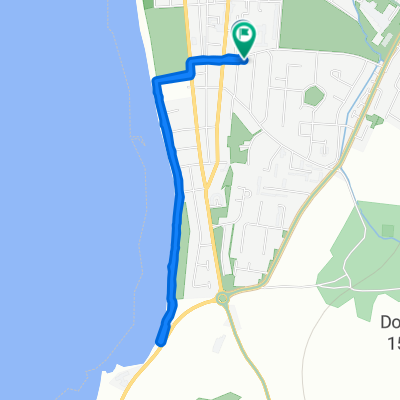
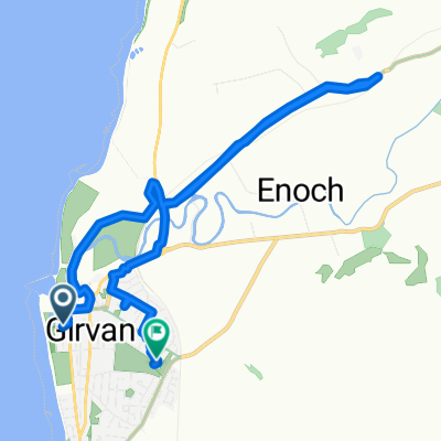
This 19th section of St Ninian’s Way starts at the centre of Girvan on the signposted Ayrshire Coastal Path. Go north along the coast to Dipple (6km) . Join the A77 briefly and then continue along the coast on ACP to Turnberry (3km). Continue north along coast, then turn east, through airport and go north to junction with A719 at Maidens (3 km). Go east along A719 to junction with minor road going south (1.5km). . Take minor road to T-junction with A77(2 km). Turn left and go north-east along the A77 To Kirkoswald (1 km). Visit Souter Johnnie’s Cottage. Continue along A 77 to junction with minor road going South (.5km). Go south along minor road for 100 m and then turn left across ford and proceed to road junction with A77 (3 km) . Go 500 m along A77, with Crossmraguel Abbey on your right, and leave the A77 onto a minor road, which continues alongside A77 to Carrick Academy((2km) , then take the A77 to Maybole centre and Town Hall (.5 km).
Coastal path,then into the Ayrshire hills.
Also part of the Whithorn Way - http://www.whithornway.org . courtesy of the WWSG where a detailed route description with grid references is available.
For a map overview of Part 1 and Part 2 of St Ninian’s Way please go to https://www.bikemap.net/en/route/3548129-st-ninians-way-carlisle-to-st-andrews-part-1-carlisle-to-whithorn/
St Ninian’s Way is one of the great pilgrim routes in Scotland to St Andrews - The Way of St Andrews - For other routes see http://www.thewayofstandrews.com
- -:--
- Czas
- 23,9 km
- Dystans
- 206 m
- Przewyższenia
- 128 m
- Spadek
- ---
- Śr. Prędkość
- ---
- Maks. wysokość

Kontynuuj z Bikemap
Użyj, edytuj lub pobierz tę trasę rowerową
Chcesz przejechać trasę St Ninian's Way- Girvan to Maybole lub dostosować ją do swojej wycieczki? Oto, co możesz zrobić z tą trasą na Bikemap:
Darmowe funkcje
- Zapisz tę trasę jako ulubioną lub w kolekcji
- Skopiuj i zaplanuj swoją wersję tej trasy
- Synchronizuj swoją trasę z Garminem lub Wahoo
Funkcje Premium
3 dni bezpłatnej wersji próbnej lub jednorazowa opłata. Dowiedz się więcej o Bikemap Premium.
- Nawiguj po tej trasie na iOS i Androidzie
- Eksportuj plik GPX / KML tej trasy
- Stwórz swój własny wydruk (wypróbuj za darmo)
- Pobierz tę trasę do nawigacji offline
Odkryj więcej funkcji Premium.
Uzyskaj Bikemap PremiumOd naszej społeczności
Girvan: Inne popularne trasy rozpoczynające się tutaj
 23 Back Road, Girvan to 47 Main Street, Girvan
- Dystans
- 100,4 km
- Przewyższenia
- 1279 m
- Spadek
- 1285 m
- Lokalizacja
- Girvan, Szkocja, Zjednoczone Królestwo Wielkiej Brytanii
 15 Back Road, Girvan to 47 Main Street, Girvan
- Dystans
- 99,8 km
- Przewyższenia
- 963 m
- Spadek
- 971 m
- Lokalizacja
- Girvan, Szkocja, Zjednoczone Królestwo Wielkiej Brytanii
 Barr / Pinmore Loop (above Girvan)
- Dystans
- 27,9 km
- Przewyższenia
- 316 m
- Spadek
- 317 m
- Lokalizacja
- Girvan, Szkocja, Zjednoczone Królestwo Wielkiej Brytanii
 Hervey Road 1 to Hervey Road 1
- Dystans
- 3,3 km
- Przewyższenia
- 66 m
- Spadek
- 58 m
- Lokalizacja
- Girvan, Szkocja, Zjednoczone Królestwo Wielkiej Brytanii
 Old Daily - Maybole circuit
- Dystans
- 58,7 km
- Przewyższenia
- 550 m
- Spadek
- 552 m
- Lokalizacja
- Girvan, Szkocja, Zjednoczone Królestwo Wielkiej Brytanii
 Girvan and South Carrick Ward, Girvan to Girvan and South Carrick Ward, Girvan
- Dystans
- 28,3 km
- Przewyższenia
- 339 m
- Spadek
- 339 m
- Lokalizacja
- Girvan, Szkocja, Zjednoczone Królestwo Wielkiej Brytanii
 ayrshire
- Dystans
- 66,6 km
- Przewyższenia
- 500 m
- Spadek
- 497 m
- Lokalizacja
- Girvan, Szkocja, Zjednoczone Królestwo Wielkiej Brytanii
 Sophie and emma
- Dystans
- 10,1 km
- Przewyższenia
- 230 m
- Spadek
- 219 m
- Lokalizacja
- Girvan, Szkocja, Zjednoczone Królestwo Wielkiej Brytanii
Otwórz ją w aplikacji