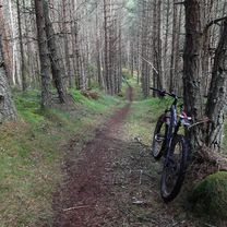
Kingussie, Newtonmore Wild Cat trail and Loch Gynack
Trasa rowerowa rozpoczynająca się w Kingussie, Szkocja, Zjednoczone Królestwo Wielkiej Brytanii.
Przegląd
O tej trasie
To jest średniej długości trasa o długości 16 km / 10 mil, odpowiednia dla rowerów górskich. Niektóre odcinki są na asfalcie i drogach gruntowych, ale inne są na nierównych szlakach, a w jednym odcinku będzie trzeba unieść rower nad kilkoma płotami. Zaplanuj 2 godziny. Mapa Ordnance Survey 35 Kingussie i Góry Monadliath. Przekąski: kawiarnie i bary w Kingussie i Newtonmore. Rozpocznij w centrum Kingussie i kieruj się dedykowaną ścieżką rowerową do Newtonmore. Skręć w prawo w Glen Road w centrum Newtonmore i podążaj tą cichą drogą, aż dojdziesz do drogowskazu do Wildcat Trail po swojej prawej stronie. Podążaj za oznaczeniami szlaku Wildcat przez lekkie lasy i pastwiska dla owiec, gdzie w niektórych miejscach teren jest nierówny. Rower będzie trzeba podnieść nad kilkoma stylami i płotami w tym odcinku (może być łatwiej zjechać i jechać po sąsiednim polu). Kiedy szlak wychodzi na otwartą wieś, wybierz drogę gruntową kilka metrów w prawo, a następnie niemal natychmiast skręć w lewo i w górę wzdłuż małego strumienia. Ta droga gruntowa zwęża się w wąski szlak po chwili, ale kontynuuj podążanie w jej kierunku, aż dojdziesz do bramy i zielonego znaku wskazującego w prawo do Kingussie. Nawierzchnia jest tutaj lepsza i prowadzi wzdłuż krawędzi lasu iglastego, aż dojdziesz do mostu nad strumieniem i dużej bramy mającej po lewej stronie. Przejdź przez tę bramę i podążaj szeroką drogą w górę i przez drugą bramę. Skręć w prawo i podążaj tą dobrze utrzymana drogą gruntową wzdłuż północnej strony malowniczej Loch Gynack. Gdy dotrzesz do drugiej strony Loch, podążaj za oznaczeniami do Kingussie. Po przekroczeniu nowo przywróconego mostu nad Gynack (poprzedni most został zniszczony przez ogon huraganu Bertha w sierpniu 2014 roku!) jest w pełni w dół na spokojnej gładkiej asfaltowej drodze z powrotem do Kingussie.
Przyjazny rowerzystom Kingussie.
- -:--
- Czas
- 16 km
- Dystans
- 219 m
- Przewyższenia
- 219 m
- Spadek
- ---
- Śr. Prędkość
- ---
- Maks. wysokość
Jakość trasy
Typy dróg i nawierzchnie na trasie
Typy dróg
Spokojna droga
3,8 km
(24 %)
Droga leśna
3,7 km
(23 %)
Powierzchnie
Utwardzona
8,3 km
(52 %)
Nieutwardzona
6,1 km
(38 %)
Asfalt
7,4 km
(46 %)
Żwir
4 km
(25 %)
Najważniejsze punkty trasy
Punkty zainteresowania na trasie

Interesujące miejsce po 0 km
Kingussie High Street

Interesujące miejsce po 5,4 km
Glen Road Newtonmore

Interesujące miejsce po 6,2 km
Right onto the Wild Cat trail

Interesujące miejsce po 8,1 km
track to Kingussie

Interesujące miejsce po 9,6 km
Gate

Interesujące miejsce po 11,2 km
View over Loch Gynack
Kontynuuj z Bikemap
Użyj, edytuj lub pobierz tę trasę rowerową
Chcesz przejechać trasę Kingussie, Newtonmore Wild Cat trail and Loch Gynack lub dostosować ją do swojej wycieczki? Oto, co możesz zrobić z tą trasą na Bikemap:
Darmowe funkcje
- Zapisz tę trasę jako ulubioną lub w kolekcji
- Skopiuj i zaplanuj swoją wersję tej trasy
- Synchronizuj swoją trasę z Garminem lub Wahoo
Funkcje Premium
3 dni bezpłatnej wersji próbnej lub jednorazowa opłata. Dowiedz się więcej o Bikemap Premium.
- Nawiguj po tej trasie na iOS i Androidzie
- Eksportuj plik GPX / KML tej trasy
- Stwórz swój własny wydruk (wypróbuj za darmo)
- Pobierz tę trasę do nawigacji offline
Odkryj więcej funkcji Premium.
Uzyskaj Bikemap PremiumOd naszej społeczności
Kingussie: Inne popularne trasy rozpoczynające się tutaj
 Kingussie to FeshieBridge 2
- Dystans
- 27,6 km
- Przewyższenia
- 235 m
- Spadek
- 235 m
- Lokalizacja
- Kingussie, Szkocja, Zjednoczone Królestwo Wielkiej Brytanii
 KOS Speyside 2019 Day 1
- Dystans
- 66,7 km
- Przewyższenia
- 243 m
- Spadek
- 273 m
- Lokalizacja
- Kingussie, Szkocja, Zjednoczone Królestwo Wielkiej Brytanii
 Day 5, 42 wet and windy miles from Newtonmore to Pitlockry
- Dystans
- 67,9 km
- Przewyższenia
- 423 m
- Spadek
- 570 m
- Lokalizacja
- Kingussie, Szkocja, Zjednoczone Królestwo Wielkiej Brytanii
 Kingussie, Newtonmore Wild Cat trail and Loch Gynack
- Dystans
- 16 km
- Przewyższenia
- 219 m
- Spadek
- 219 m
- Lokalizacja
- Kingussie, Szkocja, Zjednoczone Królestwo Wielkiej Brytanii
 Day 2 Copathlon
- Dystans
- 340,8 km
- Przewyższenia
- 870 m
- Spadek
- 1102 m
- Lokalizacja
- Kingussie, Szkocja, Zjednoczone Królestwo Wielkiej Brytanii
 Inshriachs Best 3 Descents
- Dystans
- 19,6 km
- Przewyższenia
- 419 m
- Spadek
- 421 m
- Lokalizacja
- Kingussie, Szkocja, Zjednoczone Królestwo Wielkiej Brytanii
 Inshriach Singletrack 2
- Dystans
- 25,8 km
- Przewyższenia
- 405 m
- Spadek
- 405 m
- Lokalizacja
- Kingussie, Szkocja, Zjednoczone Królestwo Wielkiej Brytanii
 Kingussie, Glen Tromie and Gaick
- Dystans
- 26,5 km
- Przewyższenia
- 313 m
- Spadek
- 57 m
- Lokalizacja
- Kingussie, Szkocja, Zjednoczone Królestwo Wielkiej Brytanii
Otwórz ją w aplikacji


