

4th Day: Pivarootsi Windmil-Peraküla campsite (115 km)
Trasa rowerowa rozpoczynająca się w Gmina Lihula, Läänemaa, Estonia.
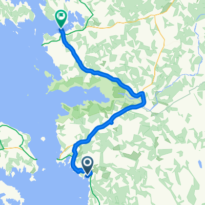
Przegląd
O tej trasie
- -:--
- Czas
- 114,3 km
- Dystans
- 91 m
- Przewyższenia
- 93 m
- Spadek
- ---
- Śr. Prędkość
- ---
- Maks. wysokość
Jakość trasy
Typy dróg i nawierzchnie na trasie
Typy dróg
Droga
56 km
(49 %)
Spokojna droga
13,7 km
(12 %)
Powierzchnie
Utwardzona
90,3 km
(79 %)
Nieutwardzona
16 km
(14 %)
Asfalt
90,3 km
(79 %)
Żwir
10,3 km
(9 %)
Najważniejsze punkty trasy
Punkty zainteresowania na trasie
Interesujące miejsce po 12,6 km
Karuse church.
Interesujące miejsce po 16,4 km
Tuudi grocery store.
Interesujące miejsce po 24,7 km
Restaurant or cafe Birgit
Interesujące miejsce po 34,3 km
Kirbla grocery store.
Interesujące miejsce po 45,4 km
Rõude grocery store.
Interesujące miejsce po 58,1 km
Martna grocery store.
Interesujące miejsce po 58,7 km
Martna church.
Interesujące miejsce po 75,8 km
Linnamäe grocery store.
Interesujące miejsce po 102 km
Dirhami cafe.
Interesujące miejsce po 102,1 km
Dirhami beacon and pier.
Interesujące miejsce po 105,8 km
Põõsaspea beacon.
Interesujące miejsce po 105,8 km
Põõsaspea rest stop. Cape Põõsaspea is the north-westernmost tip of mainland Estonia, which is important for the entire Baltic Sea. Here starts the line, which extends over Osmussaare Island to Cape Hanko and divides the sea into the Gulf of Finland and the Baltic Sea. The place is one of the best sites for watching the migration of arctic seabirds. One of the best sites for watching the migration of arctic seabirds. Rocks from the Neugrund meterorite crater – the breccias. http://www.loodusegakoos.ee/where-to-go/recreation-areas/nova-recreation-area/poosaspea-recreation-site
Interesujące miejsce po 111,8 km
Peraküla observation tower.
Interesujące miejsce po 111,9 km
Uuejõe campfire site. The campfire site is in a peaceful location on the shore of the disappearing Lake Flyvae and the Uuejõe River, wonderfully sheltered from the sea winds. Early in summer the continuous chirping of the Savi’s warbler can be heard from the reed. 300 m to the beach with “singing sand dunes”. http://www.loodusegakoos.ee/where-to-go/recreation-areas/nova-recreation-area/uuejoe-campfire-site
Interesujące miejsce po 114,3 km
Peraküla campsite. The Peraküla beach is famous for its singing sands and the clean sea. The campsite has been established to protect the fragile dunes and to provide an opportunity for holiday-makers to come as close to the seashore as possible. The sea water is refreshingly cool and warms up by the end of the summer. One can take nice walks along the shore here. Nearby is also the start of the 4.4 km study trail that offers an alternative to beach pleasures. The sea is suitable for surfers. Long beaches with singing sands, cultural heritage and mighty old trees. http://www.loodusegakoos.ee/where-to-go/recreation-areas/nova-recreation-area/perakula-campsite
Interesujące miejsce po 114,3 km
Liivaseranna-Peraküla study trail (4.4 km). The study trail that starts from and ends at Liivase rand (Sandy beach) goes through the typical landscape of the area. Along the trail we can see both young and older pine forests, sand dunes, swampy areas and lakes. Interesting cultural heritage (stone road dating from the World War I, ruins of a radio station) and environment (valuable ecosystems, singing sands, unique landscape) http://www.loodusegakoos.ee/where-to-go/recreation-areas/nova-recreation-area/liivaseranna-perakula-study-trail-4-dot-4-km
Interesujące miejsce po 114,3 km
Kalasaba cafe.
Kontynuuj z Bikemap
Użyj, edytuj lub pobierz tę trasę rowerową
Chcesz przejechać trasę 4th Day: Pivarootsi Windmil-Peraküla campsite (115 km) lub dostosować ją do swojej wycieczki? Oto, co możesz zrobić z tą trasą na Bikemap:
Darmowe funkcje
- Zapisz tę trasę jako ulubioną lub w kolekcji
- Skopiuj i zaplanuj swoją wersję tej trasy
- Podziel trasę na etapy, aby utworzyć kilkudniową wycieczkę
- Synchronizuj swoją trasę z Garminem lub Wahoo
Funkcje Premium
3 dni bezpłatnej wersji próbnej lub jednorazowa opłata. Dowiedz się więcej o Bikemap Premium.
- Nawiguj po tej trasie na iOS i Androidzie
- Eksportuj plik GPX / KML tej trasy
- Stwórz swój własny wydruk (wypróbuj za darmo)
- Pobierz tę trasę do nawigacji offline
Odkryj więcej funkcji Premium.
Uzyskaj Bikemap PremiumOd naszej społeczności
Gmina Lihula: Inne popularne trasy rozpoczynające się tutaj
 PaatsaluHaapsalu
- Dystans
- 85,9 km
- Przewyższenia
- 63 m
- Spadek
- 63 m
- Lokalizacja
- Gmina Lihula, Läänemaa, Estonia
 Lihula-Pärnu
- Dystans
- 56,5 km
- Przewyższenia
- 70 m
- Spadek
- 85 m
- Lokalizacja
- Gmina Lihula, Läänemaa, Estonia
 Lihula-Rumba-Turba
- Dystans
- 73,1 km
- Przewyższenia
- 121 m
- Spadek
- 89 m
- Lokalizacja
- Gmina Lihula, Läänemaa, Estonia
 Baltikum Part 3
- Dystans
- 231,6 km
- Przewyższenia
- 161 m
- Spadek
- 168 m
- Lokalizacja
- Gmina Lihula, Läänemaa, Estonia
 4th Day: Pivarootsi Windmil-Peraküla campsite (115 km)
- Dystans
- 114,3 km
- Przewyższenia
- 91 m
- Spadek
- 93 m
- Lokalizacja
- Gmina Lihula, Läänemaa, Estonia
![[Re5] Oidrema-Haapsalu](https://media.bikemap.net/routes/4565579/staticmaps/in_b1accf90-f915-44ee-a8ac-9d646b986b87_400x400_bikemap-2021-3D-static.png) [Re5] Oidrema-Haapsalu
[Re5] Oidrema-Haapsalu- Dystans
- 66,5 km
- Przewyższenia
- 70 m
- Spadek
- 83 m
- Lokalizacja
- Gmina Lihula, Läänemaa, Estonia
 Karuse - Munalaiu
- Dystans
- 60,8 km
- Przewyższenia
- 1717 m
- Spadek
- 1729 m
- Lokalizacja
- Gmina Lihula, Läänemaa, Estonia
 casetta signora - Oru
- Dystans
- 87,6 km
- Przewyższenia
- 80 m
- Spadek
- 69 m
- Lokalizacja
- Gmina Lihula, Läänemaa, Estonia
Otwórz ją w aplikacji