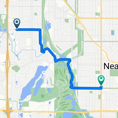
B2B00088 55411 > 55111 via downtown, Light Rail trail, and Minnehaha park
Trasa rowerowa rozpoczynająca się w Golden Valley, Minnesota, USA.
Przegląd
O tej trasie
Rozpocznij swoją przejażdżkę, kierując się na wschód na 26. Alei Północnej. Jedź 26. do North 2nd Street. Skręć w prawo (na południe) w North 2nd. Na 8. Alei Północnej przeskocz blok w lewo na North 1st Street. Jedź North 1st aż do 5. Alei Południowej. Na 5. południowy skręć w prawo i wróć na South 2nd Street. Kontynuuj na South 2nd do 11. Alei Południowej. Na 11. skręć w prawo, przejdź przez Washington, przejdź kilka bloków i wsiądź na trasę tramwaju lekkiego. Ten szlak biegnie wzdłuż torów kolejowych i zaprowadzi cię aż do Minnehaha Park. Na East 46th Street, przejdź przez Hiawatha (kierując się na wschód) do Minnehaha Avenue. Będziesz jechał ulicą Minnehaha do parku aż do zachodniego rogu, gdzie wsiądziesz na szlak rowerowy prowadzący do Fort Snelling. Gdy szlak dotrze do Pike Island, skręć w prawo (na zachód) i podążaj za szlakiem/drogą do Snelling Lake.
- -:--
- Czas
- 18,8 km
- Dystans
- 39 m
- Przewyższenia
- 95 m
- Spadek
- ---
- Śr. Prędkość
- ---
- Maks. wysokość
Najważniejsze punkty trasy
Punkty zainteresowania na trasie
Interesujące miejsce po 7,2 km
Look for the Light Rail Trail here.
Interesujące miejsce po 16,1 km
Get on the bike trail here. It will take you to Fort Snelling.
Kontynuuj z Bikemap
Użyj, edytuj lub pobierz tę trasę rowerową
Chcesz przejechać trasę B2B00088 55411 > 55111 via downtown, Light Rail trail, and Minnehaha park lub dostosować ją do swojej wycieczki? Oto, co możesz zrobić z tą trasą na Bikemap:
Darmowe funkcje
- Zapisz tę trasę jako ulubioną lub w kolekcji
- Skopiuj i zaplanuj swoją wersję tej trasy
- Synchronizuj swoją trasę z Garminem lub Wahoo
Funkcje Premium
3 dni bezpłatnej wersji próbnej lub jednorazowa opłata. Dowiedz się więcej o Bikemap Premium.
- Nawiguj po tej trasie na iOS i Androidzie
- Eksportuj plik GPX / KML tej trasy
- Stwórz swój własny wydruk (wypróbuj za darmo)
- Pobierz tę trasę do nawigacji offline
Odkryj więcej funkcji Premium.
Uzyskaj Bikemap PremiumOd naszej społeczności
Golden Valley: Inne popularne trasy rozpoczynające się tutaj
 Theodore Worth to Waconia - <Poor> Parley Lake Rd section
- Dystans
- 97,4 km
- Przewyższenia
- 142 m
- Spadek
- 142 m
- Lokalizacja
- Golden Valley, Minnesota, USA
 44 Mile Tour D'Amico
- Dystans
- 66,9 km
- Przewyższenia
- 201 m
- Spadek
- 201 m
- Lokalizacja
- Golden Valley, Minnesota, USA
 B2B00321 55442>55411 via Culver Rd, Kyle Ave, Theo Wirth Pkwy & Plymouth Ave
- Dystans
- 5 km
- Przewyższenia
- 37 m
- Spadek
- 37 m
- Lokalizacja
- Golden Valley, Minnesota, USA
 Luce around Minnetonka
- Dystans
- 80 km
- Przewyższenia
- 145 m
- Spadek
- 138 m
- Lokalizacja
- Golden Valley, Minnesota, USA
 6/28/19
- Dystans
- 17,9 km
- Przewyższenia
- 74 m
- Spadek
- 77 m
- Lokalizacja
- Golden Valley, Minnesota, USA
 B2B00649 55411>55344 via Luce Line, Plymouth Rd, Baker Rd
- Dystans
- 28,3 km
- Przewyższenia
- 155 m
- Spadek
- 160 m
- Lokalizacja
- Golden Valley, Minnesota, USA
 Loop 5/20/20
- Dystans
- 14,8 km
- Przewyższenia
- 95 m
- Spadek
- 93 m
- Lokalizacja
- Golden Valley, Minnesota, USA
 B2B00088 55411 > 55111 via downtown, Light Rail trail, and Minnehaha park
- Dystans
- 18,8 km
- Przewyższenia
- 39 m
- Spadek
- 95 m
- Lokalizacja
- Golden Valley, Minnesota, USA
Otwórz ją w aplikacji


