

Parcours des Traverses - Lac
Trasa rowerowa rozpoczynająca się w Oka, Québec, Kanada.
Przegląd
O tej trasie
- ENGLISH DESCRIPTION BELOW *
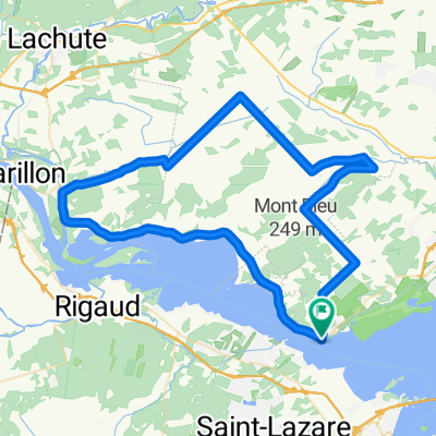
Que vous choisissiez de longer les rives du lac des Deux-Montagnes (60 km) ou que vous optiez pour la grande boucle sillonnant les terres, les villages et les collines des Basses-Laurentides et de Vaudreuil-Soulanges (140 km), le Parcours des traverses vous transportera d’une rive à l’autre, à la découverte de points de vue, d’ambiance et de paysages à la fois enchanteurs et diversifiés.
Élaboré afin de vous faire vivre une expérience inoubliable pendant une journée ou pour un séjour autour de ce magnifique cours d’eau qu’est le Lac des Deux-Montagnes, nous vous invitons à profiter de l’hospitalité de nos campings, gîtes, auberges et hôtels situés aux abords de ce circuit.
Ce parcours vous fera découvrir de magnifiques paysages en bordure du lac des Deux-Montagnes. Au centre-ville de Rigaud, faites la découverte du parc Chartier-De Lotbinière où vous pourrez faire la pause. Entrez dans l’univers de Hudson, avec son caractère unique et son décor champêtre, cette ville se veut un lieu naturel dans un magnifique décor bucolique.
Whether you choose to cycle along the shore of Lac des Deux-Montagnes (60 km) or opt for the long loop that winds through the farmlands, villages and hills of the Basses-Laurentides and Vaudreuil-Soulanges (140 km), the Parcours des traverses takes you from one bank to the other, offering myriad opportunities to discover spectacular views and a diversity of enchanting landscapes.
Ideal for either a day-trip or a longer stay in the magnificent Lac des Deux-Montagnes region, this trail promises cyclists a memorable experience. Take advantage of the hospitality offered by the campgrounds, B&Bs, inns and hotels located along the way.
This circuit takes you through spectacular landscapes along the shores of Lac des Deux-Montagnes. Discover the lovely Chartier-De Lotbinière Park, a perfect rest spot in the town of Rigaud. Continue on to the pretty municipality of Hudson, reputed for its picturesque setting and bucolic charm.
- -:--
- Czas
- 62,5 km
- Dystans
- 139 m
- Przewyższenia
- 139 m
- Spadek
- ---
- Śr. Prędkość
- ---
- Maks. wysokość

Kontynuuj z Bikemap
Użyj, edytuj lub pobierz tę trasę rowerową
Chcesz przejechać trasę Parcours des Traverses - Lac lub dostosować ją do swojej wycieczki? Oto, co możesz zrobić z tą trasą na Bikemap:
Darmowe funkcje
- Zapisz tę trasę jako ulubioną lub w kolekcji
- Skopiuj i zaplanuj swoją wersję tej trasy
- Synchronizuj swoją trasę z Garminem lub Wahoo
Funkcje Premium
3 dni bezpłatnej wersji próbnej lub jednorazowa opłata. Dowiedz się więcej o Bikemap Premium.
- Nawiguj po tej trasie na iOS i Androidzie
- Eksportuj plik GPX / KML tej trasy
- Stwórz swój własny wydruk (wypróbuj za darmo)
- Pobierz tę trasę do nawigacji offline
Odkryj więcej funkcji Premium.
Uzyskaj Bikemap PremiumOd naszej społeczności
Oka: Inne popularne trasy rozpoczynające się tutaj
 Oka 02
- Dystans
- 73,2 km
- Przewyższenia
- 259 m
- Spadek
- 259 m
- Lokalizacja
- Oka, Québec, Kanada
 homa oka
- Dystans
- 58 km
- Przewyższenia
- 147 m
- Spadek
- 151 m
- Lokalizacja
- Oka, Québec, Kanada
 De 533 Ch de l'Anse, Vaudreuil à 2645 Rue des Floralies, Vaudreuil
- Dystans
- 10,5 km
- Przewyższenia
- 3 m
- Spadek
- 0 m
- Lokalizacja
- Oka, Québec, Kanada
 Parcours des Traverses - Montagne
- Dystans
- 144,7 km
- Przewyższenia
- 368 m
- Spadek
- 368 m
- Lokalizacja
- Oka, Québec, Kanada
 Itinéraire vers 1449–1487 Ch d'Oka, Oka
- Dystans
- 12,9 km
- Przewyższenia
- 899 m
- Spadek
- 882 m
- Lokalizacja
- Oka, Québec, Kanada
 ERVLB 40 km
- Dystans
- 38,7 km
- Przewyższenia
- 156 m
- Spadek
- 154 m
- Lokalizacja
- Oka, Québec, Kanada
 Oka loop
- Dystans
- 9,2 km
- Przewyższenia
- 24 m
- Spadek
- 27 m
- Lokalizacja
- Oka, Québec, Kanada
 Rue Main 208, Hudson to Rue Rollande 15, Rigaud
- Dystans
- 20 km
- Przewyższenia
- 65 m
- Spadek
- 59 m
- Lokalizacja
- Oka, Québec, Kanada
Otwórz ją w aplikacji