

St Ninian's Way- Troon to Kilwinning
Trasa rowerowa rozpoczynająca się w Troon, Szkocja, Zjednoczone Królestwo Wielkiej Brytanii.
Przegląd
O tej trasie
Troon to Kilwinning
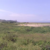
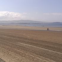
This 22nd section of St Ninian’s way starts at Troon Old Parish Church . Go South along West Portland Street to the coast and pick up the Ayrshire Coastal Path (ACP) after 100 m. Proceed west to the point (2km) and then back East along the marina to Barassie Sands (4 km) . Turn East off ACP onto marked track . Pass under two railway bridges (400m), then under A68 (1.3km). Rejoin ACP and proceed to bridge back over the A78 (2.5km). Follow ACP past the Gailes Marsh Nature Reserve (1km) towards Irvine and track junction (2km) , veer right (North along track until it rejoins ACP (1 km) . Continue through Irvine past the Scottish Maritime Museum and underneath the railway(1km)) and across footbridge over the River Irvine (500 m). Then proceed North along ACP and cross the river Garnock (3 km) and through the tunnel under the A78 . Continue along ACP path beside the Garnock into Kilwinning and arrive at the ruins of the old abbey (2 km). A detailed route description with grid references is available on the Whithorn website below.
Flattish but with great variation.
Also part of the Whithorn Way - http://www.whithornway.org . courtesy of the WWSG where a detailed route description with grid references is available.
For a map overview of Part 1 and Part 2 of St Ninian’s Way please go to https://www.bikemap.net/en/route/3548129-st-ninians-way-carlisle-to-st-andrews-part-1-carlisle-to-whithorn/
St Ninian’s Way is one of the great pilgrim routes in Scotland to St Andrews - The Way of St Andrews - For other routes see http://www.thewayofstandrews.com
- -:--
- Czas
- 20,1 km
- Dystans
- 40 m
- Przewyższenia
- 25 m
- Spadek
- ---
- Śr. Prędkość
- ---
- Maks. wysokość

Jakość trasy
Typy dróg i nawierzchnie na trasie
Typy dróg
Droga rowerowa
15,6 km
(77 %)
Spokojna droga
3,3 km
(16 %)
Powierzchnie
Utwardzona
15,2 km
(75 %)
Asfalt
15,2 km
(75 %)
Niezdefiniowany
5 km
(25 %)
Najważniejsze punkty trasy
Punkty zainteresowania na trasie
Interesujące miejsce po 10,2 km
Gailes Marsh Nature Reserve
Interesujące miejsce po 13,6 km
Scottish Maritime Museum
Kontynuuj z Bikemap
Użyj, edytuj lub pobierz tę trasę rowerową
Chcesz przejechać trasę St Ninian's Way- Troon to Kilwinning lub dostosować ją do swojej wycieczki? Oto, co możesz zrobić z tą trasą na Bikemap:
Darmowe funkcje
- Zapisz tę trasę jako ulubioną lub w kolekcji
- Skopiuj i zaplanuj swoją wersję tej trasy
- Synchronizuj swoją trasę z Garminem lub Wahoo
Funkcje Premium
3 dni bezpłatnej wersji próbnej lub jednorazowa opłata. Dowiedz się więcej o Bikemap Premium.
- Nawiguj po tej trasie na iOS i Androidzie
- Eksportuj plik GPX / KML tej trasy
- Stwórz swój własny wydruk (wypróbuj za darmo)
- Pobierz tę trasę do nawigacji offline
Odkryj więcej funkcji Premium.
Uzyskaj Bikemap PremiumOd naszej społeczności
Troon: Inne popularne trasy rozpoczynające się tutaj
 From Troon to Culzean Castle and Home
- Dystans
- 113,2 km
- Przewyższenia
- 2287 m
- Spadek
- 2347 m
- Lokalizacja
- Troon, Szkocja, Zjednoczone Królestwo Wielkiej Brytanii
 7 St Meddans St, Troon to 7 St Meddans St, Troon
- Dystans
- 40,3 km
- Przewyższenia
- 3 m
- Spadek
- 6 m
- Lokalizacja
- Troon, Szkocja, Zjednoczone Królestwo Wielkiej Brytanii
 4 Bowman Warren Wynd, Troon to 4 Bowman Warren Wynd, Troon
- Dystans
- 22,5 km
- Przewyższenia
- 3 m
- Spadek
- 14 m
- Lokalizacja
- Troon, Szkocja, Zjednoczone Królestwo Wielkiej Brytanii
 26 Hillhouse Road, Troon to 6 Bowman Warren Wynd, Troon
- Dystans
- 11,5 km
- Przewyższenia
- 0 m
- Spadek
- 7 m
- Lokalizacja
- Troon, Szkocja, Zjednoczone Królestwo Wielkiej Brytanii
 Queen's Drive 124 to Queen's Drive 124
- Dystans
- 9,6 km
- Przewyższenia
- 36 m
- Spadek
- 43 m
- Lokalizacja
- Troon, Szkocja, Zjednoczone Królestwo Wielkiej Brytanii
 South Beach 3 to Wardneuk Court 2, Girdle Toll
- Dystans
- 19,3 km
- Przewyższenia
- 47 m
- Spadek
- 82 m
- Lokalizacja
- Troon, Szkocja, Zjednoczone Królestwo Wielkiej Brytanii
 2 Boyd Place, Troon to 4 Bowman Warren Wynd, Troon
- Dystans
- 21,5 km
- Przewyższenia
- 76 m
- Spadek
- 85 m
- Lokalizacja
- Troon, Szkocja, Zjednoczone Królestwo Wielkiej Brytanii
 From Troon to Culzean Castle and Home
- Dystans
- 113,2 km
- Przewyższenia
- 2287 m
- Spadek
- 2347 m
- Lokalizacja
- Troon, Szkocja, Zjednoczone Królestwo Wielkiej Brytanii
Otwórz ją w aplikacji