Cucharon
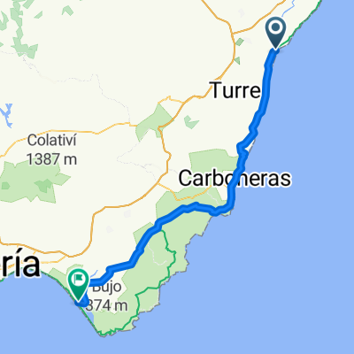
Trasa rowerowa rozpoczynająca się w Vera, Andaluzja, Hiszpania.
Przegląd
O tej trasie
Starting from Vera, the route is fairly flat for the first 12km and then there is a climb of 8km to the top of the mountain. After the first 2km of the climb there are some interesting old mining buildings. At the top of the climb is an option to go to the aerial masts at the summit. From the top of the hill to the bar at Los Lobos is 24km almost entirely downhill.
- -:--
- Czas
- 44,7 km
- Dystans
- 659 m
- Przewyższenia
- 683 m
- Spadek
- ---
- Śr. Prędkość
- ---
- Maks. wysokość
Najważniejsze punkty trasy
Punkty zainteresowania na trasie
Interesujące miejsce po 4,2 km
Vera airfield
Interesujące miejsce po 12,1 km
Old silver mines
Interesujące miejsce po 14 km
View of the dam
Interesujące miejsce po 18,9 km
Aerial masts
Interesujące miejsce po 23,4 km
Enter the rambla here
Interesujące miejsce po 42,9 km
El Control bar at Los Lobos
Kontynuuj z Bikemap
Użyj, edytuj lub pobierz tę trasę rowerową
Chcesz przejechać trasę Cucharon lub dostosować ją do swojej wycieczki? Oto, co możesz zrobić z tą trasą na Bikemap:
Darmowe funkcje
- Zapisz tę trasę jako ulubioną lub w kolekcji
- Skopiuj i zaplanuj swoją wersję tej trasy
- Synchronizuj swoją trasę z Garminem lub Wahoo
Funkcje Premium
3 dni bezpłatnej wersji próbnej lub jednorazowa opłata. Dowiedz się więcej o Bikemap Premium.
- Nawiguj po tej trasie na iOS i Androidzie
- Eksportuj plik GPX / KML tej trasy
- Stwórz swój własny wydruk (wypróbuj za darmo)
- Pobierz tę trasę do nawigacji offline
Odkryj więcej funkcji Premium.
Uzyskaj Bikemap PremiumOd naszej społeczności
Vera: Inne popularne trasy rozpoczynające się tutaj
 VERA-Las Alparatas-TURRE-Cortijo Cabrera-La Carrasca-Los Moralicos-La Adelfa-SOPALMO-GARRUCHA-VERA
- Dystans
- 67,3 km
- Przewyższenia
- 1196 m
- Spadek
- 1196 m
- Lokalizacja
- Vera, Andaluzja, Hiszpania
 Sendas de Grima
- Dystans
- 42,8 km
- Przewyższenia
- 354 m
- Spadek
- 352 m
- Lokalizacja
- Vera, Andaluzja, Hiszpania
 Ovejuna
- Dystans
- 45,3 km
- Przewyższenia
- 429 m
- Spadek
- 411 m
- Lokalizacja
- Vera, Andaluzja, Hiszpania
 VERA-Las Cunas-PALOMARES-VILLARICOS-El Salar-VERA
- Dystans
- 28,4 km
- Przewyższenia
- 199 m
- Spadek
- 199 m
- Lokalizacja
- Vera, Andaluzja, Hiszpania
 Serena
- Dystans
- 42,2 km
- Przewyższenia
- 517 m
- Spadek
- 499 m
- Lokalizacja
- Vera, Andaluzja, Hiszpania
 Cucharon
- Dystans
- 44,7 km
- Przewyższenia
- 659 m
- Spadek
- 683 m
- Lokalizacja
- Vera, Andaluzja, Hiszpania
 Vera - Cabo de Gata 82km
- Dystans
- 81,9 km
- Przewyższenia
- 568 m
- Spadek
- 563 m
- Lokalizacja
- Vera, Andaluzja, Hiszpania
 I Desafío Baria Cross-Runing 2017
- Dystans
- 23,1 km
- Przewyższenia
- 229 m
- Spadek
- 229 m
- Lokalizacja
- Vera, Andaluzja, Hiszpania
Otwórz ją w aplikacji


