Charleville-Mézieres Rance
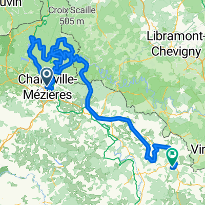
Trasa rowerowa rozpoczynająca się w Charleville-Mézières, Alsace-Champagne-Ardenne-Lorraine, France.
Przegląd
O tej trasie
La voie verte is very nice along the Meuse. The ascent until Arreux is quite long and not so interesting as you go through the forest. The road through Houldizy seemed to have a clear view on the surroundings so I would recommend the ascent through Houldizy.
Then you go through very nice villages with houses made of stone.
You can stop in Rocroi, it has a very nice citadel to see.
Between Rocroi and Cul des sarts, nothing special. Countryside.
The road between Cul des Sarts and Baileux is very nice ! It goes through forest and country side. Then you can stop in Chimay, very nice city to stop. Then you catch the Ravel L109, which is very nice, all forest.
All roads in good conditions.
- -:--
- Czas
- 78,1 km
- Dystans
- 473 m
- Przewyższenia
- 397 m
- Spadek
- ---
- Śr. Prędkość
- ---
- Maks. wysokość
Jakość trasy
Typy dróg i nawierzchnie na trasie
Typy dróg
Droga
40,6 km
(52 %)
Droga rowerowa
17,8 km
(23 %)
Powierzchnie
Utwardzona
57,6 km
(74 %)
Asfalt
57,6 km
(74 %)
Niezdefiniowany
20,5 km
(26 %)
Kontynuuj z Bikemap
Użyj, edytuj lub pobierz tę trasę rowerową
Chcesz przejechać trasę Charleville-Mézieres Rance lub dostosować ją do swojej wycieczki? Oto, co możesz zrobić z tą trasą na Bikemap:
Darmowe funkcje
- Zapisz tę trasę jako ulubioną lub w kolekcji
- Skopiuj i zaplanuj swoją wersję tej trasy
- Synchronizuj swoją trasę z Garminem lub Wahoo
Funkcje Premium
3 dni bezpłatnej wersji próbnej lub jednorazowa opłata. Dowiedz się więcej o Bikemap Premium.
- Nawiguj po tej trasie na iOS i Androidzie
- Eksportuj plik GPX / KML tej trasy
- Stwórz swój własny wydruk (wypróbuj za darmo)
- Pobierz tę trasę do nawigacji offline
Odkryj więcej funkcji Premium.
Uzyskaj Bikemap PremiumOd naszej społeczności
Charleville-Mézières: Inne popularne trasy rozpoczynające się tutaj
- Frankrike dag 1
- Dystans
- 95,9 km
- Przewyższenia
- 397 m
- Spadek
- 462 m
- Lokalizacja
- Charleville-Mézières, Alsace-Champagne-Ardenne-Lorraine, France
- France Ultime : Fourmies - Charleville-Mézières
- Dystans
- 188,2 km
- Przewyższenia
- 1941 m
- Spadek
- 1874 m
- Lokalizacja
- Charleville-Mézières, Alsace-Champagne-Ardenne-Lorraine, France
- N stage 14 ..... Charleville-Mézières – Valenciennes 3 Sept 2012
- Dystans
- 124,7 km
- Przewyższenia
- 343 m
- Spadek
- 468 m
- Lokalizacja
- Charleville-Mézières, Alsace-Champagne-Ardenne-Lorraine, France
- 2019-5-L- 4. Etappe
- Dystans
- 162,5 km
- Przewyższenia
- 1121 m
- Spadek
- 808 m
- Lokalizacja
- Charleville-Mézières, Alsace-Champagne-Ardenne-Lorraine, France
- d7 - Emik 2022
- Dystans
- 80,8 km
- Przewyższenia
- 709 m
- Spadek
- 756 m
- Lokalizacja
- Charleville-Mézières, Alsace-Champagne-Ardenne-Lorraine, France
- Bouillon1
- Dystans
- 60,7 km
- Przewyższenia
- 620 m
- Spadek
- 437 m
- Lokalizacja
- Charleville-Mézières, Alsace-Champagne-Ardenne-Lorraine, France
- Montmédy - Charleville-Mézières
- Dystans
- 201,1 km
- Przewyższenia
- 1600 m
- Spadek
- 1535 m
- Lokalizacja
- Charleville-Mézières, Alsace-Champagne-Ardenne-Lorraine, France
- 02 Charleville - Monthermé - Givet
- Dystans
- 79,1 km
- Przewyższenia
- 289 m
- Spadek
- 334 m
- Lokalizacja
- Charleville-Mézières, Alsace-Champagne-Ardenne-Lorraine, France
Otwórz ją w aplikacji