

St Ninian's Way- Kirkintilloch to Falkirk
Trasa rowerowa rozpoczynająca się w Kirkintilloch, Szkocja, Zjednoczone Królestwo Wielkiej Brytanii.
Przegląd
O tej trasie
This 27th section of St Ninian’s Way starts on the Forth and Clyde Canal tow path where it is joined by the John Muir Way from the north, and continues along JMW all the way to Falkirk, often parallel to the Antonine Wall, and switching to the Union Canal.
This is a long section but there are plenty of towns along the way where overnight accommodation can be found.
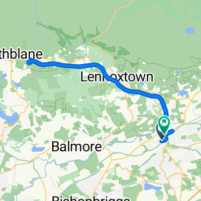
From Kirkintilloch proceed east along north bank of Forth and Clyde Canal on BR 754. After 100m the tow path is joined by the John Muir Way from the north. Proceed to Twechar (6 km). Follow JMW across bridge and up along Antonine Wall, over Croy Hill (4 km) to bridge over canal where JMW rejoins the canal tow path (2 km), then keep along JMW and tow path to Banknock (4 km) and then Bonnybridge (6 km). Continue on JMW across bridge and along Antonine Wall to Falkirk Wheel (3 km). Then go along JMW across Union Canal, and through woods and along paths to bridge (3km). Cross bridge and rejoin canal tow path to Falkirk High Street area (6 km).
A great experience - from tramping like a Roman legionary along the historic Antonine Wall to marvelling at modern and towering engineering marvel, the Falkirk Wheel, for canal navigation.
For more details and ordnance survey map of this route please go to
http://johnmuirway.org/route/kilsyth-falkirk
For a map overview of Part 1 and Part 2 of St Ninian’s Way please go to https://www.bikemap.net/en/route/3548129-st-ninians-way-carlisle-to-st-andrews-part-1-carlisle-to-whithorn/
St Ninian’s Way is one of the great pilgrim routes in Scotland to St Andrews - The Way of St Andrews - For other routes see http://www.thewayofstandrews.com
- -:--
- Czas
- 29,9 km
- Dystans
- 136 m
- Przewyższenia
- 108 m
- Spadek
- ---
- Śr. Prędkość
- ---
- Maks. wysokość

Jakość trasy
Typy dróg i nawierzchnie na trasie
Typy dróg
Droga rowerowa
22,4 km
(75 %)
Droga leśna
2,1 km
(7 %)
Powierzchnie
Utwardzona
19,7 km
(66 %)
Nieutwardzona
1,1 km
(4 %)
Asfalt
19,1 km
(64 %)
Żwir
0,8 km
(3 %)
Najważniejsze punkty trasy
Punkty zainteresowania na trasie
Interesujące miejsce po 1,1 km
Joins John Muir Way
Interesujące miejsce po 4,4 km
Roman Fort
Interesujące miejsce po 7,4 km
Roman Fort
Interesujące miejsce po 10,4 km
Roman Fort
Interesujące miejsce po 23,1 km
Antonine Wall
Interesujące miejsce po 25 km
Falkirk Wheel
Kontynuuj z Bikemap
Użyj, edytuj lub pobierz tę trasę rowerową
Chcesz przejechać trasę St Ninian's Way- Kirkintilloch to Falkirk lub dostosować ją do swojej wycieczki? Oto, co możesz zrobić z tą trasą na Bikemap:
Darmowe funkcje
- Zapisz tę trasę jako ulubioną lub w kolekcji
- Skopiuj i zaplanuj swoją wersję tej trasy
- Synchronizuj swoją trasę z Garminem lub Wahoo
Funkcje Premium
3 dni bezpłatnej wersji próbnej lub jednorazowa opłata. Dowiedz się więcej o Bikemap Premium.
- Nawiguj po tej trasie na iOS i Androidzie
- Eksportuj plik GPX / KML tej trasy
- Stwórz swój własny wydruk (wypróbuj za darmo)
- Pobierz tę trasę do nawigacji offline
Odkryj więcej funkcji Premium.
Uzyskaj Bikemap PremiumOd naszej społeczności
Kirkintilloch: Inne popularne trasy rozpoczynające się tutaj
 forth & Clyde canal
- Dystans
- 16,8 km
- Przewyższenia
- 210 m
- Spadek
- 132 m
- Lokalizacja
- Kirkintilloch, Szkocja, Zjednoczone Królestwo Wielkiej Brytanii
 33–43 Alexander Place, Glasgow to 55 Bankhead Road, Glasgow
- Dystans
- 9,4 km
- Przewyższenia
- 80 m
- Spadek
- 78 m
- Lokalizacja
- Kirkintilloch, Szkocja, Zjednoczone Królestwo Wielkiej Brytanii
 Anniversary 2
- Dystans
- 59,2 km
- Przewyższenia
- 155 m
- Spadek
- 172 m
- Lokalizacja
- Kirkintilloch, Szkocja, Zjednoczone Królestwo Wielkiej Brytanii
 Torrance- Campsie Glen - Arnprior - Fintry - Balfron
- Dystans
- 76 km
- Przewyższenia
- 596 m
- Spadek
- 605 m
- Lokalizacja
- Kirkintilloch, Szkocja, Zjednoczone Królestwo Wielkiej Brytanii
 Route from St Marys Parish Church of Scotland, Cowgate, Glasgow
- Dystans
- 8,4 km
- Przewyższenia
- 93 m
- Spadek
- 61 m
- Lokalizacja
- Kirkintilloch, Szkocja, Zjednoczone Królestwo Wielkiej Brytanii
 lenzie to Balbeggie
- Dystans
- 118,4 km
- Przewyższenia
- 558 m
- Spadek
- 509 m
- Lokalizacja
- Kirkintilloch, Szkocja, Zjednoczone Królestwo Wielkiej Brytanii
 Relaxed route in Glasgow
- Dystans
- 13,8 km
- Przewyższenia
- 54 m
- Spadek
- 56 m
- Lokalizacja
- Kirkintilloch, Szkocja, Zjednoczone Królestwo Wielkiej Brytanii
 55.939, -4.155 do 55.942, -4.153
- Dystans
- 25,4 km
- Przewyższenia
- 253 m
- Spadek
- 271 m
- Lokalizacja
- Kirkintilloch, Szkocja, Zjednoczone Królestwo Wielkiej Brytanii
Otwórz ją w aplikacji