

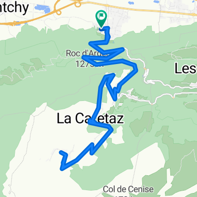
Col de Cenise via Lac Bétin
Trasa rowerowa rozpoczynająca się w Ayse, Owernia-Rodan-Alpy, Francja.
Przegląd
O tej trasie
Fantastic climb in north Alps. (This is not Col du Mont-Cenis). The detour to the lake required some pushing and the descent down to the road to Cenise was pure hiking. But fun. Cenise itself is paved to 1570 metres then gravel to 1724 metres
- -:--
- Czas
- 44,8 km
- Dystans
- 1641 m
- Przewyższenia
- 1641 m
- Spadek
- ---
- Śr. Prędkość
- ---
- Maks. wysokość

Zdjęcia trasy

Najważniejsze punkty trasy
Punkty zainteresowania na trasie
Interesujące miejsce po 15,5 km
Lac Bétin - 1460 metres
Interesujące miejsce po 25 km
Col de Cenise - 1724 metres
Kontynuuj z Bikemap
Użyj, edytuj lub pobierz tę trasę rowerową
Chcesz przejechać trasę Col de Cenise via Lac Bétin lub dostosować ją do swojej wycieczki? Oto, co możesz zrobić z tą trasą na Bikemap:
Darmowe funkcje
- Zapisz tę trasę jako ulubioną lub w kolekcji
- Skopiuj i zaplanuj swoją wersję tej trasy
- Synchronizuj swoją trasę z Garminem lub Wahoo
Funkcje Premium
3 dni bezpłatnej wersji próbnej lub jednorazowa opłata. Dowiedz się więcej o Bikemap Premium.
- Nawiguj po tej trasie na iOS i Androidzie
- Eksportuj plik GPX / KML tej trasy
- Stwórz swój własny wydruk (wypróbuj za darmo)
- Pobierz tę trasę do nawigacji offline
Odkryj więcej funkcji Premium.
Uzyskaj Bikemap PremiumOd naszej społeczności
Ayse: Inne popularne trasy rozpoczynające się tutaj
 Col de Solaison
- Dystans
- 24,1 km
- Przewyższenia
- 1045 m
- Spadek
- 1045 m
- Lokalizacja
- Ayse, Owernia-Rodan-Alpy, Francja
 L_etape_du tour_Ayse-Marignier-LaRamaz-JouxPlaines_Morzine_LeGets_Ayse
- Dystans
- 111,2 km
- Przewyższenia
- 2431 m
- Spadek
- 2441 m
- Lokalizacja
- Ayse, Owernia-Rodan-Alpy, Francja
 col les fleuries
- Dystans
- 56,1 km
- Przewyższenia
- 690 m
- Spadek
- 688 m
- Lokalizacja
- Ayse, Owernia-Rodan-Alpy, Francja
 Col de Solaison
- Dystans
- 24 km
- Przewyższenia
- 1362 m
- Spadek
- 1301 m
- Lokalizacja
- Ayse, Owernia-Rodan-Alpy, Francja
 Grand Bernard
- Dystans
- 58,5 km
- Przewyższenia
- 1165 m
- Spadek
- 1169 m
- Lokalizacja
- Ayse, Owernia-Rodan-Alpy, Francja
 Glieres Raid
- Dystans
- 106,5 km
- Przewyższenia
- 2801 m
- Spadek
- 2803 m
- Lokalizacja
- Ayse, Owernia-Rodan-Alpy, Francja
 Col de Solaizon
- Dystans
- 47,1 km
- Przewyższenia
- 1740 m
- Spadek
- 1579 m
- Lokalizacja
- Ayse, Owernia-Rodan-Alpy, Francja
 Ue, duex trois... Solaison!
- Dystans
- 54 km
- Przewyższenia
- 2130 m
- Spadek
- 1074 m
- Lokalizacja
- Ayse, Owernia-Rodan-Alpy, Francja
Otwórz ją w aplikacji