

Gotthard Challenge
Trasa rowerowa rozpoczynająca się w Andermatt, Uri, Szwajcaria.
Przegląd
O tej trasie
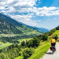
With three legendary passes that regularly feature in the Tour de Suisse, this loop ranks among the great alpine classics. Although just 106km in length, it should not be underestimated: with almost 40km of climbing, it presents a major challenge.
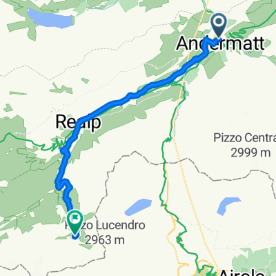
Starting in Andermatt in Canton Uri, the first pass is the Furka: 11km of climbing to reach the summit at alt. 2436m. You then enter Canton Valais for the long descent to Gletsch followed by Ulrichen in the Upper Rhone valley, known locally as the Goms. Time to think of taking food and drink on board, since you are about to make the ascent to the Nufenen pass (alt. 2478m) after 13km of climbing punctuated by long straights over 10% in gradient. Featuring Switzerland’s second-highest metalled pass road (only the Umbrail is higher), the Nufenen is a challenge in itself. The summit marks the gateway to another of Switzerland’s cantons: Ticino. There now follows a marvellous, extended descent towards Italian-speaking Airolo, where the day’s third and final ascent starts to the Gotthard at alt. 2091m. The world’s fourth-longest road tunnel swallows most of the north-south traffic; what is left takes the main pass road. Cyclists climb the ancient road, call the Tremola. Uniquely for the Alps, its 24 upper hairpin bends feature cobblestones. Enough to make you forget the 3000m-plus of difference in altitude you have been climbing today. Once at the top, Andermatt is no more than a few kilometres further on (and down!). Time for a well-earned rest in this quintessential village in the heart of the Swiss Alps.
- -:--
- Czas
- 105,9 km
- Dystans
- 3023 m
- Przewyższenia
- 3021 m
- Spadek
- ---
- Śr. Prędkość
- ---
- Maks. wysokość

Jakość trasy
Typy dróg i nawierzchnie na trasie
Typy dróg
Ruchliwa droga
95,8 km
(90 %)
Spokojna droga
5,5 km
(5 %)
Powierzchnie
Utwardzona
93,6 km
(88 %)
Nieutwardzona
0,9 km
(<1 %)
Asfalt
91,5 km
(86 %)
Beton
1,3 km
(1 %)
Kontynuuj z Bikemap
Użyj, edytuj lub pobierz tę trasę rowerową
Chcesz przejechać trasę Gotthard Challenge lub dostosować ją do swojej wycieczki? Oto, co możesz zrobić z tą trasą na Bikemap:
Darmowe funkcje
- Zapisz tę trasę jako ulubioną lub w kolekcji
- Skopiuj i zaplanuj swoją wersję tej trasy
- Podziel trasę na etapy, aby utworzyć kilkudniową wycieczkę
- Synchronizuj swoją trasę z Garminem lub Wahoo
Funkcje Premium
3 dni bezpłatnej wersji próbnej lub jednorazowa opłata. Dowiedz się więcej o Bikemap Premium.
- Nawiguj po tej trasie na iOS i Androidzie
- Eksportuj plik GPX / KML tej trasy
- Stwórz swój własny wydruk (wypróbuj za darmo)
- Pobierz tę trasę do nawigacji offline
Odkryj więcej funkcji Premium.
Uzyskaj Bikemap PremiumOd naszej społeczności
Andermatt: Inne popularne trasy rozpoczynające się tutaj
 Rheinradweg
- Dystans
- 1085,7 km
- Przewyższenia
- 107 m
- Spadek
- 1544 m
- Lokalizacja
- Andermatt, Uri, Szwajcaria
 Andermatt 3
- Dystans
- 158,9 km
- Przewyższenia
- 3905 m
- Spadek
- 3702 m
- Lokalizacja
- Andermatt, Uri, Szwajcaria
 Rhine Cycle Route, EuroVelo 15 - Andermatt to Basel
- Dystans
- 492,2 km
- Przewyższenia
- 6424 m
- Spadek
- 7590 m
- Lokalizacja
- Andermatt, Uri, Szwajcaria
 Reuss 1 bis Flüelen
- Dystans
- 32,7 km
- Przewyższenia
- 587 m
- Spadek
- 1287 m
- Lokalizacja
- Andermatt, Uri, Szwajcaria
 Witenwasseren Bike
- Dystans
- 17,3 km
- Przewyższenia
- 808 m
- Spadek
- 26 m
- Lokalizacja
- Andermatt, Uri, Szwajcaria
 Transalpine (7) Andermatt - Visp
- Dystans
- 89,5 km
- Przewyższenia
- 1685 m
- Spadek
- 2290 m
- Lokalizacja
- Andermatt, Uri, Szwajcaria
 20.09.2010 Furka, Nufenen, Gotthard
- Dystans
- 98,5 km
- Przewyższenia
- 2959 m
- Spadek
- 2959 m
- Lokalizacja
- Andermatt, Uri, Szwajcaria
 Furka-Nufenen-Gotthard-Oberalp
- Dystans
- 135,9 km
- Przewyższenia
- 4637 m
- Spadek
- 4527 m
- Lokalizacja
- Andermatt, Uri, Szwajcaria
Otwórz ją w aplikacji