

Säntis Classic
Trasa rowerowa rozpoczynająca się w Weinfelden, Thurgau, Switzerland.
Przegląd
O tej trasie
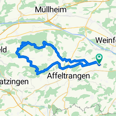
This loop follows the route of the Säntis Classic, an annual challenge that attracts almost 2000 cyclists.
Leaving Weinfelden in Canton Thurgau, the road rises gently in the countryside before descending to Wil. This is where you enter Canton St. Gallen.
The route undulates as it enters the hilly Toggenburg region. At Ebnat-Kappel, you continue to follow the Thur river upstream along the valley’s flank, taking a charming little road that meanders amid the farms away from the traffic.
The main ascent starts at Neu Sankt Johann and consists of a number of ramps (gradient: 7-8%) through the meadows interspersed with level sections. The pass itself is reached at alt. 1278m and offers views of the Säntis (alt. 2502m), the main peak in the regions which can be accessed via aerial cableway. In fine weather, this peak offers views not only of Switzerland, but also of Germany, Austria, Liechtenstein and France!
A rapid descent leads to Urnäsch, after which a series of back roads bring you to Herisau, the capital of Canton Appenzell Ausserrhoden. The 40km return leg to Weinfelden is largely downhill.
- -:--
- Czas
- 123,8 km
- Dystans
- 1204 m
- Przewyższenia
- 1204 m
- Spadek
- ---
- Śr. Prędkość
- ---
- Maks. wysokość

Jakość trasy
Typy dróg i nawierzchnie na trasie
Typy dróg
Droga
38,7 km
(31 %)
Ruchliwa droga
37,8 km
(30 %)
Powierzchnie
Utwardzona
93 km
(75 %)
Nieutwardzona
0,1 km
(<1 %)
Asfalt
81,6 km
(66 %)
Nawierzchnia (nieokreślona)
11,4 km
(9 %)
Kontynuuj z Bikemap
Użyj, edytuj lub pobierz tę trasę rowerową
Chcesz przejechać trasę Säntis Classic lub dostosować ją do swojej wycieczki? Oto, co możesz zrobić z tą trasą na Bikemap:
Darmowe funkcje
- Zapisz tę trasę jako ulubioną lub w kolekcji
- Skopiuj i zaplanuj swoją wersję tej trasy
- Podziel trasę na etapy, aby utworzyć kilkudniową wycieczkę
- Synchronizuj swoją trasę z Garminem lub Wahoo
Funkcje Premium
3 dni bezpłatnej wersji próbnej lub jednorazowa opłata. Dowiedz się więcej o Bikemap Premium.
- Nawiguj po tej trasie na iOS i Androidzie
- Eksportuj plik GPX / KML tej trasy
- Stwórz swój własny wydruk (wypróbuj za darmo)
- Pobierz tę trasę do nawigacji offline
Odkryj więcej funkcji Premium.
Uzyskaj Bikemap PremiumOd naszej społeczności
Weinfelden: Inne popularne trasy rozpoczynające się tutaj
 thurathlon 2014 velostrecke
- Dystans
- 47,4 km
- Przewyższenia
- 495 m
- Spadek
- 495 m
- Lokalizacja
- Weinfelden, Thurgau, Switzerland
 Frauenfeld-Weinfelden
- Dystans
- 33,6 km
- Przewyższenia
- 80 m
- Spadek
- 80 m
- Lokalizacja
- Weinfelden, Thurgau, Switzerland
 thurathlon 2013 bike
- Dystans
- 29,3 km
- Przewyższenia
- 350 m
- Spadek
- 309 m
- Lokalizacja
- Weinfelden, Thurgau, Switzerland
 säntisClassic 2009
- Dystans
- 130,1 km
- Przewyższenia
- 1884 m
- Spadek
- 1864 m
- Lokalizacja
- Weinfelden, Thurgau, Switzerland
 Relaxed route in Weinfelden
- Dystans
- 25,4 km
- Przewyższenia
- 104 m
- Spadek
- 104 m
- Lokalizacja
- Weinfelden, Thurgau, Switzerland
 32km Roundtrip from Friltschen
- Dystans
- 31,8 km
- Przewyższenia
- 502 m
- Spadek
- 498 m
- Lokalizacja
- Weinfelden, Thurgau, Switzerland
 Weinfelden-Nollen
- Dystans
- 41,2 km
- Przewyższenia
- 488 m
- Spadek
- 488 m
- Lokalizacja
- Weinfelden, Thurgau, Switzerland
 Säntis Classic
- Dystans
- 130,8 km
- Przewyższenia
- 1103 m
- Spadek
- 1106 m
- Lokalizacja
- Weinfelden, Thurgau, Switzerland
Otwórz ją w aplikacji