
Το Μονοπάτι της Εκεχειρίας - The Route of Truce
Trasa rowerowa rozpoczynająca się w Synoikismós Chavaríou, Western Greece, Grecja.
Przegląd
O tej trasie
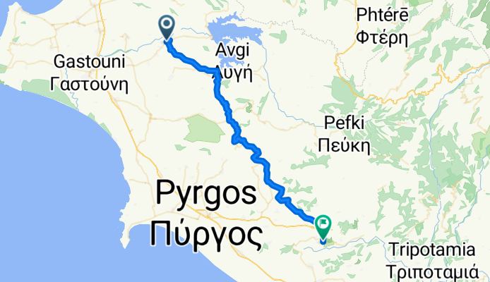
Οικοτουριστική Διαδρομή Ήλιδας - Ολυμπίας "Το Μονοπάτι της Εκεχειρίας" / Eco-Touristic Route Ilis - Olympia "The Route of Truce"
Starting from Ancient Ilis, the “Route of Truce” crosses 13 semi-hilly villages of the Ilia Prefecture and Municipalities, Ilis (Dafni, Keramidia, Dafniotissa, Peristeri), Pyrgos (Chimadio, Sopi, Karatoulas, Magoula, Latzoi), Ancient Olympia (Iraklia, Pournari, Pelopio, Platanos), and ends in Ancient Olympia.
Through the “Route of Truce”, the visitors run along a route full of olive trees, vines, pomegranates, and herbs. Along the way, visitors will also be able to visit the towns of Ιlis and Olympia and learn more about the culture and the history of the area.
Through this project, we wish to raise awareness of the “Route of Truce,” inland Greece, and abroad in order to encourage tourism within the Elis hinterland.
- -:--
- Czas
- 49,8 km
- Dystans
- 588 m
- Przewyższenia
- 579 m
- Spadek
- ---
- Śr. Prędkość
- ---
- Maks. wysokość

Zdjęcia trasy


Jakość trasy
Typy dróg i nawierzchnie na trasie
Typy dróg
Spokojna droga
23,6 km
(47 %)
Droga
12,3 km
(25 %)
Powierzchnie
Utwardzona
14,3 km
(29 %)
Asfalt
11 km
(22 %)
Nawierzchnia (nieokreślona)
3,2 km
(6 %)
Kontynuuj z Bikemap
Użyj, edytuj lub pobierz tę trasę rowerową
Chcesz przejechać trasę Το Μονοπάτι της Εκεχειρίας - The Route of Truce lub dostosować ją do swojej wycieczki? Oto, co możesz zrobić z tą trasą na Bikemap:
Darmowe funkcje
- Zapisz tę trasę jako ulubioną lub w kolekcji
- Skopiuj i zaplanuj swoją wersję tej trasy
- Synchronizuj swoją trasę z Garminem lub Wahoo
Funkcje Premium
3 dni bezpłatnej wersji próbnej lub jednorazowa opłata. Dowiedz się więcej o Bikemap Premium.
- Nawiguj po tej trasie na iOS i Androidzie
- Eksportuj plik GPX / KML tej trasy
- Stwórz swój własny wydruk (wypróbuj za darmo)
- Pobierz tę trasę do nawigacji offline
Odkryj więcej funkcji Premium.
Uzyskaj Bikemap PremiumOd naszej społeczności
Synoikismós Chavaríou: Inne popularne trasy rozpoczynające się tutaj
 Cycling Tour Pinios Lake & Elis Archeological Site
- Dystans
- 21,9 km
- Przewyższenia
- 88 m
- Spadek
- 219 m
- Lokalizacja
- Synoikismós Chavaríou, Western Greece, Grecja
 Limni Pineas - Patra Track Nr. 6
- Dystans
- 52,6 km
- Przewyższenia
- 778 m
- Spadek
- 851 m
- Lokalizacja
- Synoikismós Chavaríou, Western Greece, Grecja
 Το Μονοπάτι της Εκεχειρίας - The Route of Truce
- Dystans
- 49,8 km
- Przewyższenia
- 588 m
- Spadek
- 579 m
- Lokalizacja
- Synoikismós Chavaríou, Western Greece, Grecja
Otwórz ją w aplikacji