

Getting high the easy way.
Trasa rowerowa rozpoczynająca się w Cruce de Arinaga, Wyspy Kanaryjskie, Hiszpania.
Przegląd
O tej trasie
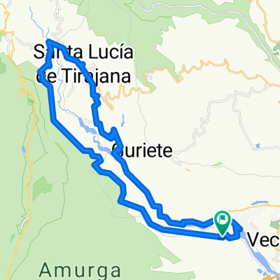
Kręta, łagodna wspinaczka wzdłuż wyschniętego koryta rzeki, mijająca gospodarstwa kozie i tradycyjne kanaryjskie domy w jaskiniach, a następnie dość intensywna, ale krótka wspinaczka do El Sitio de Abajo, po której następuje ponad 10 km prawie całkowitego zjazdu wzdłuż dobrze ugruntowanej ścieżki górskiej.
Gwarantowane niesamowite widoki, to świetna wycieczka popołudniowa i autentyczne spojrzenie na historię Gran Canarii.
Co najbardziej mi się podoba w tej trasie, to to, że chociaż pierwsza połowa to wszystko pod górę, jest to bardzo łagodne i dość ładne - w surowy sposób. Wspinaczka staje się poważna tylko na kilka kilometrów na samym końcu (blisko jeziora znanego jako La Sorrueda, gdzie skręcasz w lewo) - więc dostajesz się bardzo wysoko bardzo szybko.
Nie daj się zwieść rzece zaznaczonej na mapach okolicy. Mieszkam w domu z widokiem na dolinę prawie od dwóch lat i nigdy nie widziałem tam ani kropli wody - nawet w deszczowe dni - i musiałem pokonać tę trasę 20 razy lub więcej.
Szlak kończy się w Aldea Blanca, a droga prowadzi z powrotem do startu.
Brak sklepów i wody, więc zaopatrz się.
- -:--
- Czas
- 26,2 km
- Dystans
- 674 m
- Przewyższenia
- 673 m
- Spadek
- ---
- Śr. Prędkość
- ---
- Maks. wysokość

Jakość trasy
Typy dróg i nawierzchnie na trasie
Typy dróg
Droga leśna
17,3 km
(66 %)
Spokojna droga
5 km
(19 %)
Powierzchnie
Utwardzona
5 km
(19 %)
Nieutwardzona
15,5 km
(59 %)
Ziemia
8,9 km
(34 %)
Żwir
6,6 km
(25 %)
Najważniejsze punkty trasy
Punkty zainteresowania na trasie
Interesujące miejsce po 12 km
There's usually enough water in the lake for a refreshing dip if you fancy.
Interesujące miejsce po 12,2 km
Things only start to get tough from here...
Kontynuuj z Bikemap
Użyj, edytuj lub pobierz tę trasę rowerową
Chcesz przejechać trasę Getting high the easy way. lub dostosować ją do swojej wycieczki? Oto, co możesz zrobić z tą trasą na Bikemap:
Darmowe funkcje
- Zapisz tę trasę jako ulubioną lub w kolekcji
- Skopiuj i zaplanuj swoją wersję tej trasy
- Synchronizuj swoją trasę z Garminem lub Wahoo
Funkcje Premium
3 dni bezpłatnej wersji próbnej lub jednorazowa opłata. Dowiedz się więcej o Bikemap Premium.
- Nawiguj po tej trasie na iOS i Androidzie
- Eksportuj plik GPX / KML tej trasy
- Stwórz swój własny wydruk (wypróbuj za darmo)
- Pobierz tę trasę do nawigacji offline
Odkryj więcej funkcji Premium.
Uzyskaj Bikemap PremiumOd naszej społeczności
Cruce de Arinaga: Inne popularne trasy rozpoczynające się tutaj
 Ruta Aldea Blanca - Santa Lucia
- Dystans
- 38,9 km
- Przewyższenia
- 770 m
- Spadek
- 778 m
- Lokalizacja
- Cruce de Arinaga, Wyspy Kanaryjskie, Hiszpania
 Arinaga, Vargas, Burrero, Arinaga
- Dystans
- 17,7 km
- Przewyższenia
- 189 m
- Spadek
- 196 m
- Lokalizacja
- Cruce de Arinaga, Wyspy Kanaryjskie, Hiszpania
 12-09-22- Castillo Romeral - Alcampo- Telde- C de Romeral
- Dystans
- 81,4 km
- Przewyższenia
- 596 m
- Spadek
- 596 m
- Lokalizacja
- Cruce de Arinaga, Wyspy Kanaryjskie, Hiszpania
 Getting high the easy way.
- Dystans
- 26,2 km
- Przewyższenia
- 674 m
- Spadek
- 673 m
- Lokalizacja
- Cruce de Arinaga, Wyspy Kanaryjskie, Hiszpania
 De Calle del Prof Sventenius, 44, Santa Lucía de Tirajana a Calle de Extremadura, Santa Lucía de Tirajana
- Dystans
- 18,5 km
- Przewyższenia
- 232 m
- Spadek
- 234 m
- Lokalizacja
- Cruce de Arinaga, Wyspy Kanaryjskie, Hiszpania
 Getting away from it all and taking in the crocs
- Dystans
- 25,8 km
- Przewyższenia
- 380 m
- Spadek
- 379 m
- Lokalizacja
- Cruce de Arinaga, Wyspy Kanaryjskie, Hiszpania
 Aldea Blanca mejorada
- Dystans
- 36,4 km
- Przewyższenia
- 794 m
- Spadek
- 794 m
- Lokalizacja
- Cruce de Arinaga, Wyspy Kanaryjskie, Hiszpania
 Vecindario-Sorrueda-Gallego-Aldea blanca
- Dystans
- 8,4 km
- Przewyższenia
- 87 m
- Spadek
- 88 m
- Lokalizacja
- Cruce de Arinaga, Wyspy Kanaryjskie, Hiszpania
Otwórz ją w aplikacji