
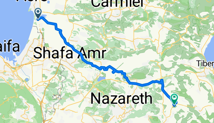
Acre To Kfar Kama 18
Trasa rowerowa rozpoczynająca się w Akka, Dystrykt Północny, Izrael.
Przegląd
O tej trasie
"Tjat'ejm'e Jauzypk'ych'er" "Śladami przodków": Ku pamięci naszych przodków
Rowerem wzdłuż trasy Czerkiesów z Akki do Kfar Kama w 1878 roku.
Według wszystkich opinii, Kfar Kama został zasiedlony w 1878 roku. Osadnicy są częścią resztek narodu czerkieskiego, który przetrwał próbę anihilacji narodu czerkieskiego przez Imperium Rosyjskie.
W 1864 roku zostali zmuszeni do opuszczenia Kaukazu i osiedlenia się na Bałkanach. Po 14 latach na Bałkanach zostali zmuszeni do ponownego odejścia i dotarli na wybrzeża Akki, gdzie pozostali na krótki okres, a następnie osiedli w Kamie.
Cele: 1. Poczuj i spróbuj osiągnąć głębokość i zakres trudności, jakie doświadczyli nasi przodkowie w drodze do Kfar Kama 2. Docenić determinację i wysiłki naszych przodków, aby zapewnić ciągłość narodu czerkieskiego 3. Wzmocnić uczucie i uznanie zobowiązania do tej ciągłości.
Zaprojektowane dla doświadczonych czerkieskich rowerzystów W razie pytań: Monir Lavai - Menedżer Centrum Społeczności 050-7235939
- -:--
- Czas
- 53,5 km
- Dystans
- 332 m
- Przewyższenia
- 143 m
- Spadek
- ---
- Śr. Prędkość
- ---
- Maks. wysokość
Kontynuuj z Bikemap
Użyj, edytuj lub pobierz tę trasę rowerową
Chcesz przejechać trasę Acre To Kfar Kama 18 lub dostosować ją do swojej wycieczki? Oto, co możesz zrobić z tą trasą na Bikemap:
Darmowe funkcje
- Zapisz tę trasę jako ulubioną lub w kolekcji
- Skopiuj i zaplanuj swoją wersję tej trasy
- Synchronizuj swoją trasę z Garminem lub Wahoo
Funkcje Premium
3 dni bezpłatnej wersji próbnej lub jednorazowa opłata. Dowiedz się więcej o Bikemap Premium.
- Nawiguj po tej trasie na iOS i Androidzie
- Eksportuj plik GPX / KML tej trasy
- Stwórz swój własny wydruk (wypróbuj za darmo)
- Pobierz tę trasę do nawigacji offline
Odkryj więcej funkcji Premium.
Uzyskaj Bikemap PremiumOd naszej społeczności
Akka: Inne popularne trasy rozpoczynające się tutaj
 מסעף עין המפרץ, עכו to Unnamed Road, Kfar Masaryk
- Dystans
- 1,7 km
- Przewyższenia
- 8 m
- Spadek
- 9 m
- Lokalizacja
- Akka, Dystrykt Północny, Izrael
 Unnamed Road to Yehuda Burla Street 6, Acre
- Dystans
- 5,5 km
- Przewyższenia
- 72 m
- Spadek
- 49 m
- Lokalizacja
- Akka, Dystrykt Północny, Izrael
 מסעאופניים17-תחנותרענון
- Dystans
- 76,1 km
- Przewyższenia
- 559 m
- Spadek
- 326 m
- Lokalizacja
- Akka, Dystrykt Północny, Izrael
 Ako to Roash hanikra
- Dystans
- 35,3 km
- Przewyższenia
- 89 m
- Spadek
- 84 m
- Lokalizacja
- Akka, Dystrykt Północny, Izrael
 David Noy Street 39, Acre do HaPalmach Street 71-73, Safed
- Dystans
- 48,8 km
- Przewyższenia
- 1357 m
- Spadek
- 586 m
- Lokalizacja
- Akka, Dystrykt Północny, Izrael
 Acre To Kfar Kama 18
- Dystans
- 53,5 km
- Przewyższenia
- 332 m
- Spadek
- 143 m
- Lokalizacja
- Akka, Dystrykt Północny, Izrael
 עכו to דרך ללא שם, עין המפרץ
- Dystans
- 63 km
- Przewyższenia
- 287 m
- Spadek
- 289 m
- Lokalizacja
- Akka, Dystrykt Północny, Izrael
 My dusty trip
- Dystans
- 28,5 km
- Przewyższenia
- 32 m
- Spadek
- 48 m
- Lokalizacja
- Akka, Dystrykt Północny, Izrael
Otwórz ją w aplikacji