

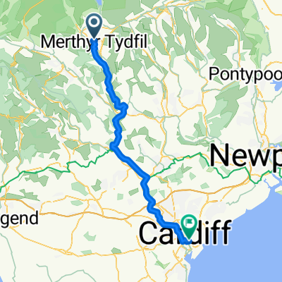
Lôn Las Cymru (Easter 2017)
Trasa rowerowa rozpoczynająca się w Merthyr Tydfil, Walia, Zjednoczone Królestwo Wielkiej Brytanii.
Przegląd
O tej trasie
- -:--
- Czas
- 254,1 km
- Dystans
- 1617 m
- Przewyższenia
- 1702 m
- Spadek
- ---
- Śr. Prędkość
- ---
- Maks. wysokość

Jakość trasy
Typy dróg i nawierzchnie na trasie
Typy dróg
Spokojna droga
109,3 km
(43 %)
Droga rowerowa
50,8 km
(20 %)
Powierzchnie
Utwardzona
116,9 km
(46 %)
Nieutwardzona
20,3 km
(8 %)
Asfalt
91,5 km
(36 %)
Nawierzchnia (nieokreślona)
25,4 km
(10 %)
Najważniejsze punkty trasy
Punkty zainteresowania na trasie
Nocleg po 39,4 km
Priory Mill Farm Campsite Hay Road Brecon LD3 7SR priorymill@gmail.com http://www.priorymillfarm.co.uk - Have a phone charging area - Seating for cyclists - Might sell eggs
Interesujące miejsce po 77,1 km
Erwood Station Gallery & tea room Former railway station & old train cars turned gallery, displaying modern work by Welsh artists. 10.30am – 5.00pm Daily Last orders at the Tea Room 4.30pm Llandeilo Graban, Builth LD2 3SJ erwoodstation.com
Nocleg po 90,4 km
FForest Fields Campsite Fforest Fields, Hundred House, Llandrindod Wells LD1 5RT 01982 570406 https://fforestfields.co.uk/campsite - Electric hook-up points and an award winning toilet block where the hot water and showers are free - Drying room, laundry and washing-up room with deep sinks, washing machines, spin dryer and tumble dryers. - small shop selling simple essentials like milk and bread, fresh orange, yogurts, eggs and the famous Bujok Bacon! We also have home grown sausages and now home grown pork burgers. - Unless it's a busy time (bank holidays etc.), you can just show up.
Interesujące miejsce po 129,5 km
Elan Valley Visitor Centre & Café opens 9:30
Interesujące miejsce po 205,9 km
Centre for Alternative Technology Llwyngwern Quarry, Pantperthog, Machynlleth SY20 9AZ cat.org.uk Summer opening times Open 10am - 5pm daily including Shop and Cafe. Adult - £8.50 Concession* - £7.50 (students) NCN 8 passes via the rail station, right up to the entrance of the CAT Visitor Centre. This is a very pleasant, albeit a little hilly, route. The journey takes less than half an hour by bike and about an hour on foot. As you leave the station's main entrance turn right to reach the main road and right again under the railway bridge. Proceed along the path on the left hand side of the road. As you near the Dyfi river bridge, cross over the road again and continue through the gates and alongside the riverbank until you reach the footbridge on the left hand side. Cross over the footbridge and continue through the gate and along the pathway until you reach the white cottage. Turn right onto the minor road and continue downhill across the stream. Take the first left immediately after the bridge (there is a sign to CAT here), and continue along this lane for approximately two miles. CAT Visitor Centre is clearly signposted on arrival. Cycle parking is available on site
Kontynuuj z Bikemap
Użyj, edytuj lub pobierz tę trasę rowerową
Chcesz przejechać trasę Lôn Las Cymru (Easter 2017) lub dostosować ją do swojej wycieczki? Oto, co możesz zrobić z tą trasą na Bikemap:
Darmowe funkcje
- Zapisz tę trasę jako ulubioną lub w kolekcji
- Skopiuj i zaplanuj swoją wersję tej trasy
- Podziel trasę na etapy, aby utworzyć kilkudniową wycieczkę
- Synchronizuj swoją trasę z Garminem lub Wahoo
Funkcje Premium
3 dni bezpłatnej wersji próbnej lub jednorazowa opłata. Dowiedz się więcej o Bikemap Premium.
- Nawiguj po tej trasie na iOS i Androidzie
- Eksportuj plik GPX / KML tej trasy
- Stwórz swój własny wydruk (wypróbuj za darmo)
- Pobierz tę trasę do nawigacji offline
Odkryj więcej funkcji Premium.
Uzyskaj Bikemap PremiumOd naszej społeczności
Merthyr Tydfil: Inne popularne trasy rozpoczynające się tutaj
 28-08 de Mertbyr a Cardiff
- Dystans
- 46,2 km
- Przewyższenia
- 95 m
- Spadek
- 282 m
- Lokalizacja
- Merthyr Tydfil, Walia, Zjednoczone Królestwo Wielkiej Brytanii
 pen y fan
- Dystans
- 34 km
- Przewyższenia
- 721 m
- Spadek
- 727 m
- Lokalizacja
- Merthyr Tydfil, Walia, Zjednoczone Królestwo Wielkiej Brytanii
 Lôn Las Cymru (Easter 2017)
- Dystans
- 254,1 km
- Przewyższenia
- 1617 m
- Spadek
- 1702 m
- Lokalizacja
- Merthyr Tydfil, Walia, Zjednoczone Królestwo Wielkiej Brytanii
 Brecon to home (via Tumble)
- Dystans
- 119,1 km
- Przewyższenia
- 881 m
- Spadek
- 1031 m
- Lokalizacja
- Merthyr Tydfil, Walia, Zjednoczone Królestwo Wielkiej Brytanii
 Aberdare Road to Keir Hardie Health Park
- Dystans
- 24,2 km
- Przewyższenia
- 269 m
- Spadek
- 270 m
- Lokalizacja
- Merthyr Tydfil, Walia, Zjednoczone Królestwo Wielkiej Brytanii
 Heolgerrig loop
- Dystans
- 7,4 km
- Przewyższenia
- 77 m
- Spadek
- 75 m
- Lokalizacja
- Merthyr Tydfil, Walia, Zjednoczone Królestwo Wielkiej Brytanii
 Taf Fechan Forest
- Dystans
- 9,2 km
- Przewyższenia
- 159 m
- Spadek
- 154 m
- Lokalizacja
- Merthyr Tydfil, Walia, Zjednoczone Królestwo Wielkiej Brytanii
 2019 – Underground Beacons (12.4.-14.4.)
- Dystans
- 83,4 km
- Przewyższenia
- 691 m
- Spadek
- 840 m
- Lokalizacja
- Merthyr Tydfil, Walia, Zjednoczone Królestwo Wielkiej Brytanii
Otwórz ją w aplikacji