

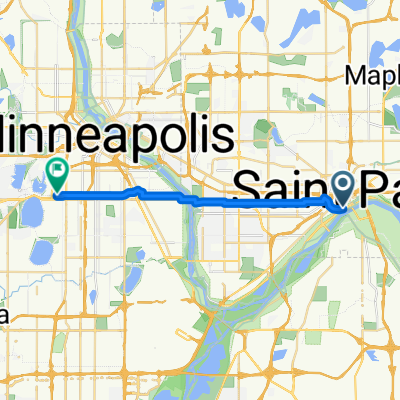
B2B00192 55102>55404viaShepherdRd/MissBlvd/WRiverPkwy/MidtwnGrnway
Trasa rowerowa rozpoczynająca się w Saint Paul, Minnesota, USA.
Przegląd
O tej trasie
Ta trasa jest zdecydowanie dłuższa, ale znacznie ciekawsza i szybsza. Bardzo mało przystanków w porównaniu do trasy przez miasto. Jedź Shepherd Road West wzdłuż rzeki Mississippi. Możesz jechać ścieżką rowerową lub drogą. Podążaj Shepherd Rd. aż do 35E, aż zamieni się w East Mississippi River Blvd. Kontynuuj na East Mississippi mijając zakład Forda. Przejedź pod mostem Ford Pkwy. i wykonaj natychmiastowy ostry zakręt w prawo do Ford Pkwy. i przetnij Mississippi na moście Forda. Tuż na końcu mostu jest ścieżka w prawo, która prowadzi cię w dół do West River Pkwy. Podążaj West River Pkwy. zarówno drogą, jak i ścieżką rowerową. Przejedź pod Lake Street i kontynuuj. Na E.27th Street znajduje się ścieżka w górę do Midtown Greenway Bike Trail. Weź ścieżkę rowerową na zachód. Na Hiawatha Avenue możesz kontynuować prosto i przejść na czerwonym świetle lub podążyć ścieżką rowerową nad nowym mostem Martin Sabo. (Bardzo fajne nocą z niebieskimi światłami). Kontynuuj na Greenway aż dotrzesz do Chicago Avenue. Wyjdź po schodach na ulicę i idź na północ po Chicago do 26th Street i twojego celu.
- -:--
- Czas
- 21,8 km
- Dystans
- 131 m
- Przewyższenia
- 86 m
- Spadek
- ---
- Śr. Prędkość
- 258 m
- Maks. wysokość
Jakość trasy
Typy dróg i nawierzchnie na trasie
Typy dróg
Droga rowerowa
16,8 km
(77 %)
Droga
3,9 km
(18 %)
Powierzchnie
Utwardzona
12,9 km
(59 %)
Asfalt
11,6 km
(53 %)
Beton
0,9 km
(4 %)
Najważniejsze punkty trasy
Punkty zainteresowania na trasie
Interesujące miejsce po 18,9 km
At this point you can continue across Hiawatha to E. 28th Street with the traffic signals or continue on the bike path to the north and over the Martin Sabo bridge.
Kontynuuj z Bikemap
Użyj, edytuj lub pobierz tę trasę rowerową
Chcesz przejechać trasę B2B00192 55102>55404viaShepherdRd/MissBlvd/WRiverPkwy/MidtwnGrnway lub dostosować ją do swojej wycieczki? Oto, co możesz zrobić z tą trasą na Bikemap:
Darmowe funkcje
- Zapisz tę trasę jako ulubioną lub w kolekcji
- Skopiuj i zaplanuj swoją wersję tej trasy
- Synchronizuj swoją trasę z Garminem lub Wahoo
Funkcje Premium
3 dni bezpłatnej wersji próbnej lub jednorazowa opłata. Dowiedz się więcej o Bikemap Premium.
- Nawiguj po tej trasie na iOS i Androidzie
- Eksportuj plik GPX / KML tej trasy
- Stwórz swój własny wydruk (wypróbuj za darmo)
- Pobierz tę trasę do nawigacji offline
Odkryj więcej funkcji Premium.
Uzyskaj Bikemap PremiumOd naszej społeczności
Saint Paul: Inne popularne trasy rozpoczynające się tutaj
 B2B00629 55102 < 55402 via Summit, River Road, West bank, Downtown
- Dystans
- 15,5 km
- Przewyższenia
- 82 m
- Spadek
- 94 m
- Lokalizacja
- Saint Paul, Minnesota, USA
 St Paul Gateway to: Brown’s creek to Stillwater and back .
- Dystans
- 64,2 km
- Przewyższenia
- 408 m
- Spadek
- 409 m
- Lokalizacja
- Saint Paul, Minnesota, USA
 B2B00368 55102 > 55417 via Shepard Rd, Godfrey, Minnehaha, River Pkwy
- Dystans
- 17,8 km
- Przewyższenia
- 96 m
- Spadek
- 119 m
- Lokalizacja
- Saint Paul, Minnesota, USA
 Jackson Street to East 7th Street
- Dystans
- 1,6 km
- Przewyższenia
- 36 m
- Spadek
- 0 m
- Lokalizacja
- Saint Paul, Minnesota, USA
 River Ramble 20
- Dystans
- 29,6 km
- Przewyższenia
- 196 m
- Spadek
- 197 m
- Lokalizacja
- Saint Paul, Minnesota, USA
 To the River Center
- Dystans
- 17,1 km
- Przewyższenia
- 117 m
- Spadek
- 90 m
- Lokalizacja
- Saint Paul, Minnesota, USA
 B2B00024 55104 > 55121 via Big Rivers Trail
- Dystans
- 16,8 km
- Przewyższenia
- 174 m
- Spadek
- 174 m
- Lokalizacja
- Saint Paul, Minnesota, USA
 B2B00418 55117>55123 via Cedar, Wabasha, Lexington, Pilot Knob Rd
- Dystans
- 20,8 km
- Przewyższenia
- 161 m
- Spadek
- 156 m
- Lokalizacja
- Saint Paul, Minnesota, USA
Otwórz ją w aplikacji