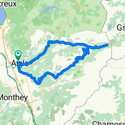
47° Nord Tour de Suisse Etappe 4
Trasa rowerowa rozpoczynająca się w Aigle, Canton of Vaud, Switzerland.
Przegląd
O tej trasie
Von Aigle aus folgen wir der Veloland Schweiz Route No 4 nach Montbovon und wechseln anschliessend auf die No 9 bis nach Château-d'Oex. Die Route steigt gleich hinter dem Ort steil durch die Weinberge empor
- -:--
- Czas
- 63,7 km
- Dystans
- 1423 m
- Przewyższenia
- 938 m
- Spadek
- ---
- Śr. Prędkość
- ---
- Maks. wysokość
Zdjęcia trasy
Jakość trasy
Typy dróg i nawierzchnie na trasie
Typy dróg
Spokojna droga
45 km
(71 %)
Ruchliwa droga
10 km
(16 %)
Powierzchnie
Utwardzona
45,8 km
(72 %)
Nieutwardzona
0,6 km
(<1 %)
Asfalt
26,8 km
(42 %)
Nawierzchnia (nieokreślona)
11,5 km
(18 %)
Najważniejsze punkty trasy
Punkty zainteresowania na trasie
Interesujące miejsce po 13 km
Tunnel Der Tunnel ist nur einspurig und ohne Beleuchtung er darf jeweils in der ersten viertelstunde befahren werden ( 9.00-9.15 10.00-10.15 usw) wer später in den Tunnel einfährt muss mit Gegenverkehr rechnen und entsprechend vorsichtig sein, es gibt ausweichstellen.
Kontynuuj z Bikemap
Użyj, edytuj lub pobierz tę trasę rowerową
Chcesz przejechać trasę 47° Nord Tour de Suisse Etappe 4 lub dostosować ją do swojej wycieczki? Oto, co możesz zrobić z tą trasą na Bikemap:
Darmowe funkcje
- Zapisz tę trasę jako ulubioną lub w kolekcji
- Skopiuj i zaplanuj swoją wersję tej trasy
- Synchronizuj swoją trasę z Garminem lub Wahoo
Funkcje Premium
3 dni bezpłatnej wersji próbnej lub jednorazowa opłata. Dowiedz się więcej o Bikemap Premium.
- Nawiguj po tej trasie na iOS i Androidzie
- Eksportuj plik GPX / KML tej trasy
- Stwórz swój własny wydruk (wypróbuj za darmo)
- Pobierz tę trasę do nawigacji offline
Odkryj więcej funkcji Premium.
Uzyskaj Bikemap PremiumOd naszej społeczności
Aigle: Inne popularne trasy rozpoczynające się tutaj
- Aigle 1/7
- Dystans
- 169,5 km
- Przewyższenia
- 2802 m
- Spadek
- 2015 m
- Lokalizacja
- Aigle, Canton of Vaud, Switzerland
- 47° Nord Tour de Suisse Etappe 4
- Dystans
- 63,7 km
- Przewyższenia
- 1423 m
- Spadek
- 938 m
- Lokalizacja
- Aigle, Canton of Vaud, Switzerland
- 2014-T12-Aigle-Moudon
- Dystans
- 51,8 km
- Przewyższenia
- 668 m
- Spadek
- 552 m
- Lokalizacja
- Aigle, Canton of Vaud, Switzerland
- Lac Hingrin Loop
- Dystans
- 65,3 km
- Przewyższenia
- 2262 m
- Spadek
- 2162 m
- Lokalizacja
- Aigle, Canton of Vaud, Switzerland
- Aigle-Mosses-Pillon-Croix-Aigle CLONED FROM ROUTE 222631
- Dystans
- 105,6 km
- Przewyższenia
- 2213 m
- Spadek
- 2213 m
- Lokalizacja
- Aigle, Canton of Vaud, Switzerland
- Rundfahrt mit Aussicht
- Dystans
- 71,3 km
- Przewyższenia
- 1942 m
- Spadek
- 1943 m
- Lokalizacja
- Aigle, Canton of Vaud, Switzerland
- Stage 1, Aigle - Meiringen
- Dystans
- 151,4 km
- Przewyższenia
- 1498 m
- Spadek
- 1326 m
- Lokalizacja
- Aigle, Canton of Vaud, Switzerland
- Aigle > Col de la Croix > Montreux
- Dystans
- 65,6 km
- Przewyższenia
- 1655 m
- Spadek
- 1678 m
- Lokalizacja
- Aigle, Canton of Vaud, Switzerland
Otwórz ją w aplikacji