

2-Tag_Aosta-ValD-isere
Trasa rowerowa rozpoczynająca się w Aosta, Regione Autonoma Valle d'Aosta, Włochy.
Przegląd
O tej trasie
Dzień 2 Wycieczka rowerowa szosowa z Handstanger
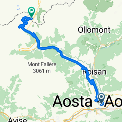
Z Aosty jedziemy około 40 km w górę doliny, tuż przed Courmayeur, zdobywając 400 m wysokości, gdzie musimy się przygotować na większy ruch drogowy. Mamy tuż przed sobą zasięg masywu Mont Blanc. W Pré St. Didier zjeżdżamy na drogę prowadzącą do Małego Świętego Bernarda. Nie jest on taki mały, ponieważ od tego miejsca do przełęczy jest aż 24 km i 1200 m przewyższenia, które trzeba pokonać, aż do 2188 m n.p.m. Maksymalne nachylenie wynosi jednak tylko 9%. Na początku jedziemy przez wąski wąwóz około 10 km do La Thuile – miejscowości sportów letnich i zimowych. Teraz dolina się otwiera i jedziemy kilkoma zakrętami o umiarkowanym nachyleniu w kierunku przełęczy, gdzie robimy porządny odpoczynek. Następnie czeka nas długa, ale tylko w górnej części stroma zjazd w kierunku Bourg-St.-Maurice. Niedługo po dotarciu do ośrodka narciarskiego La Rosière zjeżdżamy jednak z drogi przełęczy i korzystamy z mniejszych bocznych dróg w kierunku Val d’Isère. Dzięki temu oszczędzamy sobie kilkaset metrów przewyższenia, a w Sainte-Foy-Tarentaise dołączamy do drogi głównej wiodącej do Val d’Isère. Wspinaczka jest wymagająca, a do jeziora Lac de Tigne droga prowadzi przez kilka stromych odcinków aż do 1800 m n.p.m. Z jeziora Lac de Tignes rozciąga się piękny widok na sztucznie zbudowaną miejscowość Tignes. Stąd droga prowadzi przez galerie lawinowe do wąskiego przejścia i nagle dolina się otwiera, a Val d’Isère – legendarna miejscowość sportów letnich i zimowych – ukazuje się przed nami.
- -:--
- Czas
- 94,3 km
- Dystans
- 2400 m
- Przewyższenia
- 1177 m
- Spadek
- ---
- Śr. Prędkość
- ---
- Maks. wysokość

Jakość trasy
Typy dróg i nawierzchnie na trasie
Typy dróg
Spokojna droga
11,3 km
(12 %)
Droga
6,6 km
(7 %)
Powierzchnie
Utwardzona
70,7 km
(75 %)
Asfalt
70,7 km
(75 %)
Niezdefiniowany
23,6 km
(25 %)
Kontynuuj z Bikemap
Użyj, edytuj lub pobierz tę trasę rowerową
Chcesz przejechać trasę 2-Tag_Aosta-ValD-isere lub dostosować ją do swojej wycieczki? Oto, co możesz zrobić z tą trasą na Bikemap:
Darmowe funkcje
- Zapisz tę trasę jako ulubioną lub w kolekcji
- Skopiuj i zaplanuj swoją wersję tej trasy
- Podziel trasę na etapy, aby utworzyć kilkudniową wycieczkę
- Synchronizuj swoją trasę z Garminem lub Wahoo
Funkcje Premium
3 dni bezpłatnej wersji próbnej lub jednorazowa opłata. Dowiedz się więcej o Bikemap Premium.
- Nawiguj po tej trasie na iOS i Androidzie
- Eksportuj plik GPX / KML tej trasy
- Stwórz swój własny wydruk (wypróbuj za darmo)
- Pobierz tę trasę do nawigacji offline
Odkryj więcej funkcji Premium.
Uzyskaj Bikemap PremiumOd naszej społeczności
Aosta: Inne popularne trasy rozpoczynające się tutaj
 Francja: nie Pinerolo, a Aosta - reverse (BONUSY)
- Dystans
- 691,8 km
- Przewyższenia
- 9757 m
- Spadek
- 8365 m
- Lokalizacja
- Aosta, Regione Autonoma Valle d'Aosta, Włochy
 Col du Gd-St Bernard
- Dystans
- 36,9 km
- Przewyższenia
- 1917 m
- Spadek
- 23 m
- Lokalizacja
- Aosta, Regione Autonoma Valle d'Aosta, Włochy
 F52 aosta to nus
- Dystans
- 14,3 km
- Przewyższenia
- 48 m
- Spadek
- 85 m
- Lokalizacja
- Aosta, Regione Autonoma Valle d'Aosta, Włochy
 Aosta-Lago di Place Moulin-retour
- Dystans
- 63,4 km
- Przewyższenia
- 1415 m
- Spadek
- 1415 m
- Lokalizacja
- Aosta, Regione Autonoma Valle d'Aosta, Włochy
 Aosta - Aosta Day 1
- Dystans
- 140,8 km
- Przewyższenia
- 3178 m
- Spadek
- 3187 m
- Lokalizacja
- Aosta, Regione Autonoma Valle d'Aosta, Włochy
 Alps 1991 18.8. Tag4b
- Dystans
- 79,5 km
- Przewyższenia
- 1881 m
- Spadek
- 1973 m
- Lokalizacja
- Aosta, Regione Autonoma Valle d'Aosta, Włochy
 4 - Aosta - Innertkirchen
- Dystans
- 428,6 km
- Przewyższenia
- 6681 m
- Spadek
- 6634 m
- Lokalizacja
- Aosta, Regione Autonoma Valle d'Aosta, Włochy
 Alpencross 2007/2 - Aosta bis GranParadiso
- Dystans
- 43,2 km
- Przewyższenia
- 2071 m
- Spadek
- 48 m
- Lokalizacja
- Aosta, Regione Autonoma Valle d'Aosta, Włochy
Otwórz ją w aplikacji