- 38,1 km
- 323 m
- 323 m
- La Seyne-sur-Mer, Prowansja-Alpy-Lazurowe Wybrzeże, Francja
Crêtes "Marc Robert" - St Tropez - 21 Déc. 17
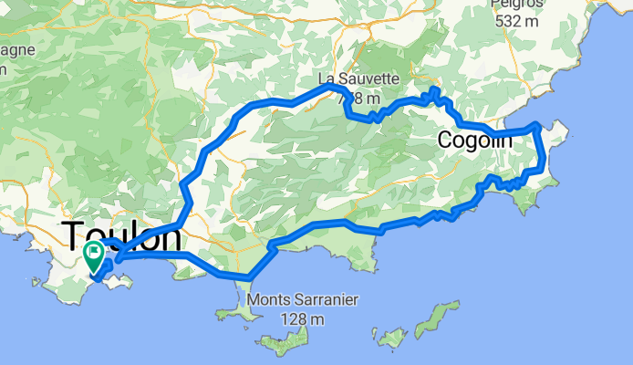
Trasa rowerowa rozpoczynająca się w La Seyne-sur-Mer, Prowansja-Alpy-Lazurowe Wybrzeże, Francja.
Przegląd
O tej trasie
La Seyne-Sablettes - Port - Pyro - Lagoubran – Toulon - La Valette – La Farlède – Solliès-Pont – Cuers – Carnoules – Pignans – Gonfaron - Col des Fourches ( 535 m ) – R.F.12 « Route des crêtes Marc Robert » ( L’Argentière – cote 660 m – Les Cinq Cèdes – Col de la Court – Pic Martin – les Roches Blanches ) – La Garde-Freinet – Grimaud – La Foux – St-Tropez – Ste Anne – Ramatuelle ( bas ) – Col de Collebasse ( 129 m ) – La Croix-Valmer – trasa – Cavalaire – Col de l’Etoile ( 123 m ) - Le Rayol – Canadel – Pramousquier – trasa – Cavalière - Le Lavandou – La Londe – L’Ayguade – Les Salins – Port w Hyères – L’Almanarre – Carqueiranne – Le Pradet – Ste Marguerite – Cap Brun – Corniche du Mourillon - Toulon – trasa – Lagoubran – Pyro - Port – Corniche Tamaris - La Seyne-Sablettes.
- -:--
- Czas
- 208,1 km
- Dystans
- 1135 m
- Przewyższenia
- 1135 m
- Spadek
- ---
- Śr. Prędkość
- ---
- Maks. wysokość
utworzono 8 lat temu temu
Jakość trasy
Typy dróg i nawierzchnie na trasie
Typy dróg
Droga rowerowa
39,5 km
(19 %)
Spokojna droga
29,1 km
(14 %)
Powierzchnie
Utwardzona
162,3 km
(78 %)
Asfalt
162,3 km
(78 %)
Niezdefiniowany
45,8 km
(22 %)
Kontynuuj z Bikemap
Użyj, edytuj lub pobierz tę trasę rowerową
Chcesz przejechać trasę Crêtes "Marc Robert" - St Tropez - 21 Déc. 17 lub dostosować ją do swojej wycieczki? Oto, co możesz zrobić z tą trasą na Bikemap:
Darmowe funkcje
- Zapisz tę trasę jako ulubioną lub w kolekcji
- Skopiuj i zaplanuj swoją wersję tej trasy
- Podziel trasę na etapy, aby utworzyć kilkudniową wycieczkę
- Synchronizuj swoją trasę z Garminem lub Wahoo
Funkcje Premium
3 dni bezpłatnej wersji próbnej lub jednorazowa opłata. Dowiedz się więcej o Bikemap Premium.
- Nawiguj po tej trasie na iOS i Androidzie
- Eksportuj plik GPX / KML tej trasy
- Stwórz swój własny wydruk (wypróbuj za darmo)
- Pobierz tę trasę do nawigacji offline
Odkryj więcej funkcji Premium.
Uzyskaj Bikemap PremiumOd naszej społeczności
La Seyne-sur-Mer: Inne popularne trasy rozpoczynające się tutaj
- Tour de Six Fours
- Ste Baume - Bras - Rocbaron - 3 Janvier 22.
- 193,9 km
- 3310 m
- 3294 m
- La Seyne-sur-Mer, Prowansja-Alpy-Lazurowe Wybrzeże, Francja
- De Rue Ernest Reyer 4B, La Seyne-sur-Mer à Rue Ernest Reyer 4B, La Seyne-sur-Mer
- 45,7 km
- 555 m
- 558 m
- La Seyne-sur-Mer, Prowansja-Alpy-Lazurowe Wybrzeże, Francja
- Crêtes "Marc Robert" - St Tropez - 21 Déc. 17
- 208,1 km
- 1135 m
- 1135 m
- La Seyne-sur-Mer, Prowansja-Alpy-Lazurowe Wybrzeże, Francja
- Mar Vivo au Brusc
- 27,1 km
- 1756 m
- 1754 m
- La Seyne-sur-Mer, Prowansja-Alpy-Lazurowe Wybrzeże, Francja
- De Rue Victor Hugo 56, La Seyne-sur-Mer à Rue Victor Hugo 69, La Seyne-sur-Mer
- 28,4 km
- 240 m
- 237 m
- La Seyne-sur-Mer, Prowansja-Alpy-Lazurowe Wybrzeże, Francja
- ''Rando du TéPéGé'' - 19 Oct. 22_Y.P.
- 206,3 km
- 2300 m
- 2299 m
- La Seyne-sur-Mer, Prowansja-Alpy-Lazurowe Wybrzeże, Francja
- Rocbaron - La Loube - Le Camp - 5 Décembre 21.
- 139,1 km
- 2755 m
- 2755 m
- La Seyne-sur-Mer, Prowansja-Alpy-Lazurowe Wybrzeże, Francja
Otwórz ją w aplikacji


