

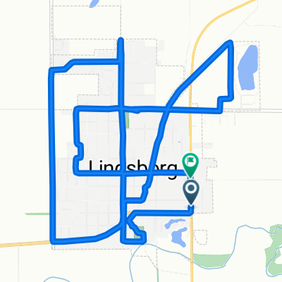
Lindsborg to Coronado Heights
Trasa rowerowa rozpoczynająca się w Lindsborg, Kansas, USA.
Przegląd
O tej trasie
Ta krótka przejażdżka z Lindsborg do Coronado Heights to piękny sposób na rozpoczęcie lub zakończenie dnia.
Jednym z najbardziej rozpoznawalnych miejsc w dolinie rzeki Smoky Hill w środkowym Kansas jest park Coronado Heights, wpisany na Krajową i Kansas Listę Miejsc Historycznych, a także wybrany jako jeden z 8 Cudów Geografii Kansas przez członków Kansas Sampler Foundation.
Wczesnych szwedzkich pionierów osiedliło się pierwotnie u stóp urwiska, ale ostatecznie przenieśli społeczność na dno doliny. Anna Olsson, córka jednego z założycieli Lindsborg, ks. Olafa Olssona, napisała w swoich wspomnieniach Dziecko Prerii, że patrząc z samego szczytu Heights, gdy czuła tęsknotę, wyobrażała sobie, że widzi aż do Szwecji.
Dominując na wysokości 300 stóp nad doliną rzeki Smoky Hill, Coronado Heights, położony około 3 mile na północny zachód od Lindsborg, znajduje się na południowym krańcu sekwencji siedmiu wzgórz znanych jako Buttes Hiszpańskie (lub czasami Buttes Smoky Hill). Formacja Dakota została złożona około 100 milionów lat temu. Coronado Heights pozostaje naturalnym środowiskiem kwiatów dzikich i traw. Yucca, agrest, jaszczurki Prairie Racerunner, sumak, szałwia i spiderwort rozwijają się w tym obszarze. Z powodu swojej naturalnej urody jest popularnym miejscem na wesela i spotkania rodzinne.
Rozwój parku Coronado Heights rozpoczął się w 1919 roku wraz z utworzeniem Lindsborg Historical Society, poprzedniczki Smoky Valley Historical Association. Zbudowano dom schronienia wokół obszaru piknikowego i do gotowania w środkowej części wzgórza. Oryginalna droga, aby umożliwić dostęp samochodowy na szczyt, została zbudowana w 1920 roku i nazwana Swensson Drive na cześć Carla Aarona Swenssona, założyciela Bethany College. Ścieżka piesza, teraz schody zlokalizowane w połowie drogi w górę wzgórza, nosi nazwę Olsson Trail, nazwana na cześć Olafa Olssona, lidera jednej z pierwszych grup Szwedów, którzy osiedlili się w dolinie. Na wczesnym etapie historii Smoky Valley było jasne, że park Coronado Heights powinien być ceniony i dostępny dla wszystkich. Jak mówi rzeźba z 1988 roku autorstwa Johna Whitfielda, znajdująca się w połowie drogi wzdłuż drogi, "Miejsce do dzielenia się."
Park Coronado Heights to miejsce, gdzie mieszkańcy Smoky Valley zgłębiają zmienne warunki pogodowe Kansas. Artyści i fotografowie od lat przyjeżdżają do Coronado Heights, aby podziwiać wyjątkową panoramę. Miękka, rodzimą piaskowiec Dakota jest usiana nazwiskami i datami sprzed lat. Szlaki turystyczne i rowerowe wiją się wokół urwiska. Mimo że niektórzy mają błędne wyobrażenie, że to sam Coronado zbudował zamek w stylu hiszpańskim, został on zbudowany w 1936 roku przez pracowników Works Progress Administration. To miejsce do obserwacji wschodu lub zachodu słońca. To idealne miejsce na lot balonem lub samolotem zdalnie sterowanym, na piknik, na spotkanie z przyjaciółmi oraz aby pokazać gościom krajobraz Smoky Valley.
- -:--
- Czas
- 14,7 km
- Dystans
- 106 m
- Przewyższenia
- 106 m
- Spadek
- ---
- Śr. Prędkość
- ---
- Maks. wysokość

Zdjęcia trasy


Jakość trasy
Typy dróg i nawierzchnie na trasie
Typy dróg
Spokojna droga
7,6 km
(52 %)
Droga
7 km
(48 %)
Powierzchnie
Nieutwardzona
1,6 km
(11 %)
Żwir
1,6 km
(11 %)
Niezdefiniowany
13,1 km
(89 %)
Kontynuuj z Bikemap
Użyj, edytuj lub pobierz tę trasę rowerową
Chcesz przejechać trasę Lindsborg to Coronado Heights lub dostosować ją do swojej wycieczki? Oto, co możesz zrobić z tą trasą na Bikemap:
Darmowe funkcje
- Zapisz tę trasę jako ulubioną lub w kolekcji
- Skopiuj i zaplanuj swoją wersję tej trasy
- Synchronizuj swoją trasę z Garminem lub Wahoo
Funkcje Premium
3 dni bezpłatnej wersji próbnej lub jednorazowa opłata. Dowiedz się więcej o Bikemap Premium.
- Nawiguj po tej trasie na iOS i Androidzie
- Eksportuj plik GPX / KML tej trasy
- Stwórz swój własny wydruk (wypróbuj za darmo)
- Pobierz tę trasę do nawigacji offline
Odkryj więcej funkcji Premium.
Uzyskaj Bikemap PremiumOd naszej społeczności
Lindsborg: Inne popularne trasy rozpoczynające się tutaj
 Lindsborg via the Meadowlark Trail to Marquette
- Dystans
- 49 km
- Przewyższenia
- 86 m
- Spadek
- 89 m
- Lokalizacja
- Lindsborg, Kansas, USA
 Cole1
Cole1- Dystans
- 16,1 km
- Przewyższenia
- 83 m
- Spadek
- 62 m
- Lokalizacja
- Lindsborg, Kansas, USA
 South Cole Street to South Cole Street
- Dystans
- 16 km
- Przewyższenia
- 81 m
- Spadek
- 56 m
- Lokalizacja
- Lindsborg, Kansas, USA
 Välkommen Trail - Lindsborg
- Dystans
- 5 km
- Przewyższenia
- 11 m
- Spadek
- 9 m
- Lokalizacja
- Lindsborg, Kansas, USA
 Lindsborg to Maxwell Wildlife Refuge
- Dystans
- 70,8 km
- Przewyższenia
- 298 m
- Spadek
- 300 m
- Lokalizacja
- Lindsborg, Kansas, USA
 Falun Classic - Lindsborg to Falun Loop
- Dystans
- 49,1 km
- Przewyższenia
- 135 m
- Spadek
- 133 m
- Lokalizacja
- Lindsborg, Kansas, USA
 Lindsborg to Coronado Heights
- Dystans
- 14,7 km
- Przewyższenia
- 106 m
- Spadek
- 106 m
- Lokalizacja
- Lindsborg, Kansas, USA
 708 Emerald Dr, Lindsborg to Bethany Dr, Lindsborg
- Dystans
- 22,6 km
- Przewyższenia
- 154 m
- Spadek
- 152 m
- Lokalizacja
- Lindsborg, Kansas, USA
Otwórz ją w aplikacji