- 97,2 km
- 1390 m
- 1402 m
- Brunswick Heads, Nowa Południowa Walia, Australia
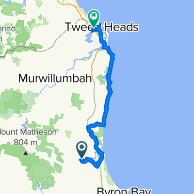
Brunswick to Tweed Beach and River Ride
Trasa rowerowa rozpoczynająca się w Brunswick Heads, Nowa Południowa Walia, Australia.
Przegląd
O tej trasie
Rozpoczynając od 'ukrytej' plaży, ta trasa prowadzi wzdłuż wspaniałego wybrzeża między rzeką Brunswick a rzeką Tweed.
Zaparkuj na małym parkingu tuż przy Rajah Road.
Przed wyruszeniem możesz przejść lub przejechać na rowerze na plażę (miękki piasek) kilka set metrów na południe. Krótka kąpiel tam teraz, lub jeśli zrobisz trasę powrotną.
Jedź na północ nieutwardzoną drogą przy brzegu rzeki przez New Brighton i do Ocean Shores.
Możesz oszukiwać tutaj i wybrać płaską (choć piaszczystą) trasę za wydmami od końca Pacific Esplanade wzdłuż Billinugel Coast Trail. To jest w porządku dla roweru hybrydowego lub mocnego roweru szosowego. Wąskie opony się nie nadają.
Lub trzymaj się mojej trasy, by stoczyć strome wzniesienie MTB z Shara Blvd, które wznosi się o około 45 m dość stromo. A potem w dół, przez niesamowicie zróżnicowaną florę na łatwej trasie MTB na Wooyung Road. Uważaj na duże, tłuste kangury bagienne, czarne kakadu i, jeśli masz szczęście, pięknego czarnego węża z czerwonym brzuchem, który się opala.
Teraz prawie płasko i łatwo przez większość drogi, bez skał lub stromego terenu. Prawie cała ścieżka rowerowa od Cabarita.
Załap się na lody w Pottsville, zrób objazd na wzgórzu, aby zobaczyć, jak fale rozbijają się i w zimie można zobaczyć wieloryby w Hastings Point, a następnie za Multi-Million$ McMansions w Casuarina i Salt.
Kiedy przejdziesz przez Cudgen Creek wchodząc do Kingscliff, spójrz w górę na światła na moście. Często jest tam duży orzeł siedzący na latarni, szukający kolacji.
Trzymaj się prawej, wzdłuż rzeki przez cały czas - jest ładna ścieżka rowerowa (jedna przejście z roweru) i do Kingscliff właściwego.
Wzdłuż odnowionego nadmorskiego bulwaru (2018) w Kingscliff - wszystko na ścieżce rowerowej.
Podążaj ścieżką po lewej stronie boiska, do rzeki w Chinderah. Wzdłuż Tweed do Fingal.
Zablokuj rowery i zobacz własny (mini) Giants Causeway Australii i starą latarnię morską.
Kończ lub przygotuj się na powrót, jeśli nie zostawiłeś zapasowego samochodu tutaj, w Sheoak Shack Gallery Cafe.
Pyszne jedzenie po drodze:
- Black Oak lub Osteria w Casuarina * Fins, French Patisserie lub Bombay Cricketers Club w Salt * Taverna (miejsce na kolację, wymaga rezerwacji), Kettles on lub Mockingbird w Kingscliff * Tweed River Seafoods w Chinderah (Fish n Chips i ładne stoły piknikowe nad rzeką) * Sheoak Shack w Fingal Wzdłuż tej trasy znajdują się również inne puby, sklepy, punkty napełniania wody, kawiarnie. Również mnóstwo miejsc kempingowych.
Nie wolno biwakować poza miejscami kempingowymi na całej trasie, a rangerzy chodzą w poszukiwaniu.
Miłej zabawy!
- -:--
- Czas
- 44,3 km
- Dystans
- 97 m
- Przewyższenia
- 97 m
- Spadek
- ---
- Śr. Prędkość
- ---
- Maks. wysokość
utworzono 7 lat temu temu
Zdjęcia trasy
Jakość trasy
Typy dróg i nawierzchnie na trasie
Typy dróg
Droga rowerowa
20,8 km
(47 %)
Droga
10,2 km
(23 %)
Powierzchnie
Utwardzona
28,8 km
(65 %)
Nieutwardzona
4 km
(9 %)
Nawierzchnia (nieokreślona)
21,7 km
(49 %)
Asfalt
7,1 km
(16 %)
Kontynuuj z Bikemap
Użyj, edytuj lub pobierz tę trasę rowerową
Chcesz przejechać trasę Brunswick to Tweed Beach and River Ride lub dostosować ją do swojej wycieczki? Oto, co możesz zrobić z tą trasą na Bikemap:
Darmowe funkcje
- Zapisz tę trasę jako ulubioną lub w kolekcji
- Skopiuj i zaplanuj swoją wersję tej trasy
- Synchronizuj swoją trasę z Garminem lub Wahoo
Funkcje Premium
3 dni bezpłatnej wersji próbnej lub jednorazowa opłata. Dowiedz się więcej o Bikemap Premium.
- Nawiguj po tej trasie na iOS i Androidzie
- Eksportuj plik GPX / KML tej trasy
- Stwórz swój własny wydruk (wypróbuj za darmo)
- Pobierz tę trasę do nawigacji offline
Odkryj więcej funkcji Premium.
Uzyskaj Bikemap PremiumOd naszej społeczności
Brunswick Heads: Inne popularne trasy rozpoczynające się tutaj
- Brunswick Heads - Coraki
- 15 Muli Muli Avenue, Ocean Shores to 13 Tindara Avenue, Ocean Shores
- 5,7 km
- 50 m
- 52 m
- Brunswick Heads, Nowa Południowa Walia, Australia
- Corella Crescent 31, Mullumbimby to Banksia Lane 14-16, Tweed Heads West
- 67,1 km
- 531 m
- 534 m
- Brunswick Heads, Nowa Południowa Walia, Australia
- Brunswick to Tweed Beach and River Ride
- 44,3 km
- 97 m
- 97 m
- Brunswick Heads, Nowa Południowa Walia, Australia
- Short ride through Brunswick Heads
- 9,1 km
- 68 m
- 67 m
- Brunswick Heads, Nowa Południowa Walia, Australia
- Billinudgel Main Arm Bike Ride
- 36,8 km
- 381 m
- 376 m
- Brunswick Heads, Nowa Południowa Walia, Australia
- Larelar Court 26, Ocean Shores to Larelar Court 26, Ocean Shores
- 10,5 km
- 77 m
- 80 m
- Brunswick Heads, Nowa Południowa Walia, Australia
- Brunswick to Byron return trip
- 27,8 km
- 374 m
- 368 m
- Brunswick Heads, Nowa Południowa Walia, Australia
Otwórz ją w aplikacji


