

Matadown - Valli del Natisone - Italy
Trasa rowerowa rozpoczynająca się w Gmina Kobarid, Gmina Kobarid, Słowenia.
Przegląd
O tej trasie
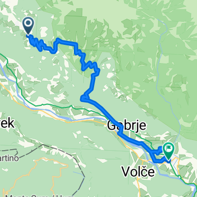
Il tracciato della Matadown parte dalla cima del monte Matajur a 1641 mt di altezza per arrivare a Sorzento in comune di San Pietro al Natisone dopo circa 12 km e 1400 mt. di dislivello negativo. La traccia è dedicata ai biker più esperti con biciclette da enduro ed è molto impegna- tiva. Nel 2017 è stato dichiarato uno dei trail naturali più belli d’Europa. La traccia parte dalla cima del monte Matajur dove è posta la Chiesetta del Redentore. Per rag- giungere la cima, si prende il sentiero che parte dal Rifu- gio Pelizzo; ristoro facilmente raggiungibile percorrendo la strada asfaltata che sale da Savogna. Dalla cima ci si dirige verso il Rifugio Dom e si svolta a destra verso il laghetto sottostante. Da qua si prosegue sulla traccia principale in direzione Passo di Glevizza. Si attraversa la strada e si prosegue lungo il sentiero sempre dritti sulla traccia principale che ci porterà sulla strada bianca che sempre in discesa conduce a Mezzana. Sotto il paese si svolta a sinistra sulla strada bianca che si percorre fino
a trovare le indicazioni che ci porteranno a Sorzento su un bellissimo sentiero. Da qui lungo la pista ciclabile si arriva a San Pietro al Natisone. È sconsigliata la percor- renza dei sentieri in condizioni di fango per motivi di sicu- rezza e per evitare l’erosione dei trail.
The Matadown track starts from the top of Mount Matajur, at 1641 mt and arrives to Sorzento, under the municipal- ity of San Pietro al Natisone, after about 12 km and 1400 mt descent. This challengingg trail its dedicated to expert cyclists of enduro. In 2017 it’s been nominated one of the most beautiful natural tracks in Europe. The trail starts from the top of Mount Matajur. To reach the top take the path from Rifugio Pelizzo (situated at the end of the paved road that goes up from Savogna). Head towards Rifugio Dom and turn right towards the pond below. From here continue on the main track towards Passo di Glevizza. Cross the road and continue straight on the main track, it will lead you to the white road that goes downhill to Mezzana. After the village turn left onto the white road and follow it until you nd the signs that will lead you to Sorzento by a beautiful path. From here along the cycle path you get to San Pietro al Natisone. It is not recom- mended the use of the track in mud conditions for security reasons and in order to prevent any damages to the trail.
- -:--
- Czas
- 11,9 km
- Dystans
- 24 m
- Przewyższenia
- 1344 m
- Spadek
- ---
- Śr. Prędkość
- ---
- Maks. wysokość

Kontynuuj z Bikemap
Użyj, edytuj lub pobierz tę trasę rowerową
Chcesz przejechać trasę Matadown - Valli del Natisone - Italy lub dostosować ją do swojej wycieczki? Oto, co możesz zrobić z tą trasą na Bikemap:
Darmowe funkcje
- Zapisz tę trasę jako ulubioną lub w kolekcji
- Skopiuj i zaplanuj swoją wersję tej trasy
- Synchronizuj swoją trasę z Garminem lub Wahoo
Funkcje Premium
3 dni bezpłatnej wersji próbnej lub jednorazowa opłata. Dowiedz się więcej o Bikemap Premium.
- Nawiguj po tej trasie na iOS i Androidzie
- Eksportuj plik GPX / KML tej trasy
- Stwórz swój własny wydruk (wypróbuj za darmo)
- Pobierz tę trasę do nawigacji offline
Odkryj więcej funkcji Premium.
Uzyskaj Bikemap PremiumOd naszej społeczności
Gmina Kobarid: Inne popularne trasy rozpoczynające się tutaj
 MTB Slowenien Soca Tour 14
- Dystans
- 23,2 km
- Przewyższenia
- 1215 m
- Spadek
- 1222 m
- Lokalizacja
- Gmina Kobarid, Gmina Kobarid, Słowenia
 Slov - Trnovo
- Dystans
- 35,8 km
- Przewyższenia
- 1218 m
- Spadek
- 1218 m
- Lokalizacja
- Gmina Kobarid, Gmina Kobarid, Słowenia
 MTB Slowenien Soca - Tour 12
- Dystans
- 15,4 km
- Przewyższenia
- 704 m
- Spadek
- 704 m
- Lokalizacja
- Gmina Kobarid, Gmina Kobarid, Słowenia
 MTB Slowenien Soca Tour 13
- Dystans
- 40,7 km
- Przewyższenia
- 1795 m
- Spadek
- 1795 m
- Lokalizacja
- Gmina Kobarid, Gmina Kobarid, Słowenia
 Alpe-Adria Trail 4-5
- Dystans
- 24 km
- Przewyższenia
- 901 m
- Spadek
- 1302 m
- Lokalizacja
- Gmina Kobarid, Gmina Kobarid, Słowenia
 Breginjski krog (ob Nadiži)
- Dystans
- 26,9 km
- Przewyższenia
- 554 m
- Spadek
- 563 m
- Lokalizacja
- Gmina Kobarid, Gmina Kobarid, Słowenia
 Ob Nadiži
- Dystans
- 43,8 km
- Przewyższenia
- 719 m
- Spadek
- 719 m
- Lokalizacja
- Gmina Kobarid, Gmina Kobarid, Słowenia
 Krog robidisce
- Dystans
- 25,1 km
- Przewyższenia
- 609 m
- Spadek
- 584 m
- Lokalizacja
- Gmina Kobarid, Gmina Kobarid, Słowenia
Otwórz ją w aplikacji