

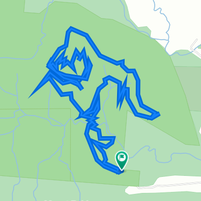
Day 3: Lake Eachem, Curtain Fig Tree and Malanda Falls Loop
Trasa rowerowa rozpoczynająca się w Atherton, State of Queensland, Australia.
Przegląd
O tej trasie
<span lang="EN-US"><span style="font-family: 'Times New Roman'; font-size: 16px;">A nice cruisy days riding from Yungaburra through the Atherton Tablelands to some of its most iconic hot spots in the tablelands including Lake Eacham, Curtain fig tree and Malanda Falls. Only minutes from Yungaburra is the famous Curtain Fig Tree, one of the best known attractions in the Tablelands. The tree stands 50 metres tall and spreads to 39 metres wide at the base and is over 800 years old.</span> curtain effect has resulted from the weight of the fig tree being too great, so the host tree fell over landing on a 45-</span><img src="file://localhost/Users/sallyschott/Library/Caches/TemporaryItems/msoclip1/01/clip_image002.png" alt="" hspace="9" width="121" height="82" align="left" /><span lang="EN-US">degree angle. The strangler vine has grown along the slanting angle of the leaning tree, dangling 15 metres to the ground. This has now formed a curtain, which has made the tree so fascinating and unusual. Malanda falls flow all year round and its brook meanders through our rainforest providing a home to many turtles and platypus and other aquatic species. The virgin Rainforest is alive with birdlife and animals and is one of the few places that the rare Lumholtz Tree Kangaroo calls home. The rainforest provides our whole park with natural air-conditioning. Its beauty will astound you. </span>
<span lang="EN-US">Lake Eacham is an extinct volcanic crater lake filled with cool, clean, crystal clear water, surrounded by 1200acres of lush tropical highland rainforest. Add a ride to Lake Barrine (18km return) if you want to do some extra kms, <span style="color: black;">Lake Barrine is hidden in World Heritage Rainforest. From here you can take an informative and relaxing rainforest and wildlife cruise around the volcanic crater brim. The 40-minute, 6km cruises provides a close-up view of one of the most complex and amazing rainforest eco-systems in the world.</span></span>
- -:--
- Czas
- 44,8 km
- Dystans
- 438 m
- Przewyższenia
- 399 m
- Spadek
- ---
- Śr. Prędkość
- 803 m
- Maks. wysokość
Jakość trasy
Typy dróg i nawierzchnie na trasie
Typy dróg
Ruchliwa droga
27,3 km
(61 %)
Spokojna droga
6,4 km
(14 %)
Powierzchnie
Utwardzona
36,3 km
(81 %)
Nieutwardzona
0,7 km
(2 %)
Asfalt
35,1 km
(78 %)
Drewno
0,9 km
(2 %)
Kontynuuj z Bikemap
Użyj, edytuj lub pobierz tę trasę rowerową
Chcesz przejechać trasę Day 3: Lake Eachem, Curtain Fig Tree and Malanda Falls Loop lub dostosować ją do swojej wycieczki? Oto, co możesz zrobić z tą trasą na Bikemap:
Darmowe funkcje
- Zapisz tę trasę jako ulubioną lub w kolekcji
- Skopiuj i zaplanuj swoją wersję tej trasy
- Synchronizuj swoją trasę z Garminem lub Wahoo
Funkcje Premium
3 dni bezpłatnej wersji próbnej lub jednorazowa opłata. Dowiedz się więcej o Bikemap Premium.
- Nawiguj po tej trasie na iOS i Androidzie
- Eksportuj plik GPX / KML tej trasy
- Stwórz swój własny wydruk (wypróbuj za darmo)
- Pobierz tę trasę do nawigacji offline
Odkryj więcej funkcji Premium.
Uzyskaj Bikemap PremiumOd naszej społeczności
Atherton: Inne popularne trasy rozpoczynające się tutaj
 Atherton - Herberton
- Dystans
- 19,6 km
- Przewyższenia
- 342 m
- Spadek
- 200 m
- Lokalizacja
- Atherton, State of Queensland, Australia
 Atherton Herberton
- Dystans
- 20,1 km
- Przewyższenia
- 340 m
- Spadek
- 245 m
- Lokalizacja
- Atherton, State of Queensland, Australia
 22-02-22 Malanda loop
- Dystans
- 19,7 km
- Przewyższenia
- 231 m
- Spadek
- 233 m
- Lokalizacja
- Atherton, State of Queensland, Australia
 21-12-17 Ath mtb 1,6,7,6,1,rd
- Dystans
- 11 km
- Przewyższenia
- 191 m
- Spadek
- 172 m
- Lokalizacja
- Atherton, State of Queensland, Australia
 Day 4: Yungaburra to Millaa Millaa (The Falls Tea House)
- Dystans
- 73,8 km
- Przewyższenia
- 782 m
- Spadek
- 638 m
- Lokalizacja
- Atherton, State of Queensland, Australia
 Herberton/Atherton Range
- Dystans
- 36,2 km
- Przewyższenia
- 899 m
- Spadek
- 838 m
- Lokalizacja
- Atherton, State of Queensland, Australia
 Rifle Range Road, Atherton to Rifle Range Road, Atherton
- Dystans
- 7,8 km
- Przewyższenia
- 221 m
- Spadek
- 223 m
- Lokalizacja
- Atherton, State of Queensland, Australia
 Day 3: Lake Eachem, Curtain Fig Tree and Malanda Falls Loop CLONED FROM ROUTE 437914
- Dystans
- 44,9 km
- Przewyższenia
- 475 m
- Spadek
- 475 m
- Lokalizacja
- Atherton, State of Queensland, Australia
Otwórz ją w aplikacji