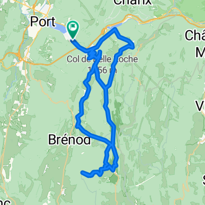
Lac Genin VTT Rouge et Bleue Forest Trails and Col de Sentier

Trasa rowerowa rozpoczynająca się w Nantua, Owernia-Rodan-Alpy, Francja.

Przegląd

O tej trasie

-:--
Czas
44,7 km
Dystans
907 m
Przewyższenia
907 m
Spadek
---
Śr. Prędkość
---
Maks. wysokość
Will

utworzono 7 lat temu temu

Zdjęcia trasy

Zdjęcie 1 trasy Bikemap „Lac Genin VTT Rouge et Bleue  Forest Trails and Col de Sentier”Zdjęcie 2 trasy Bikemap „Lac Genin VTT Rouge et Bleue  Forest Trails and Col de Sentier”Zdjęcie 3 trasy Bikemap „Lac Genin VTT Rouge et Bleue  Forest Trails and Col de Sentier”Zdjęcie 4 trasy Bikemap „Lac Genin VTT Rouge et Bleue  Forest Trails and Col de Sentier”Zdjęcie 5 trasy Bikemap „Lac Genin VTT Rouge et Bleue  Forest Trails and Col de Sentier”

Najważniejsze punkty trasy

Punkty zainteresowania na trasie

  1. Interesujące miejsce po 10,5 km

    Col du Sentier

Kontynuuj z Bikemap

Użyj, edytuj lub pobierz tę trasę rowerową

Chcesz przejechać trasę Lac Genin VTT Rouge et Bleue Forest Trails and Col de Sentier lub dostosować ją do swojej wycieczki? Oto, co możesz zrobić z tą trasą na Bikemap:

Darmowe funkcje

Funkcje Premium

3 dni bezpłatnej wersji próbnej lub jednorazowa opłata. Dowiedz się więcej o Bikemap Premium.

Odkryj więcej funkcji Premium.

Uzyskaj Bikemap Premium

Od naszej społeczności

Nantua: Inne popularne trasy rozpoczynające się tutaj

Otwórz ją w aplikacji