

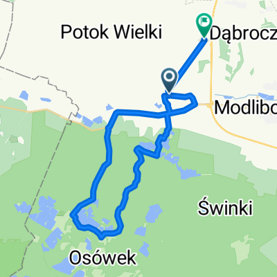
W widłach Sanu
Trasa rowerowa rozpoczynająca się w Modliborzyce, Województwo lubelskie, Polska.
Przegląd
O tej trasie
- -:--
- Czas
- 156,6 km
- Dystans
- 215 m
- Przewyższenia
- 263 m
- Spadek
- ---
- Śr. Prędkość
- ---
- Maks. wysokość

Jakość trasy
Typy dróg i nawierzchnie na trasie
Typy dróg
Droga
72 km
(46 %)
Spokojna droga
17,2 km
(11 %)
Powierzchnie
Utwardzona
136,3 km
(87 %)
Nieutwardzona
1,6 km
(1 %)
Asfalt
134,7 km
(86 %)
Nawierzchnia (nieokreślona)
1,6 km
(1 %)
Kontynuuj z Bikemap
Użyj, edytuj lub pobierz tę trasę rowerową
Chcesz przejechać trasę W widłach Sanu lub dostosować ją do swojej wycieczki? Oto, co możesz zrobić z tą trasą na Bikemap:
Darmowe funkcje
- Zapisz tę trasę jako ulubioną lub w kolekcji
- Skopiuj i zaplanuj swoją wersję tej trasy
- Podziel trasę na etapy, aby utworzyć kilkudniową wycieczkę
- Synchronizuj swoją trasę z Garminem lub Wahoo
Funkcje Premium
3 dni bezpłatnej wersji próbnej lub jednorazowa opłata. Dowiedz się więcej o Bikemap Premium.
- Nawiguj po tej trasie na iOS i Androidzie
- Eksportuj plik GPX / KML tej trasy
- Stwórz swój własny wydruk (wypróbuj za darmo)
- Pobierz tę trasę do nawigacji offline
Odkryj więcej funkcji Premium.
Uzyskaj Bikemap PremiumOd naszej społeczności
Modliborzyce: Inne popularne trasy rozpoczynające się tutaj
 Modliborzyce - Piłatka - Zdziłowice - Godziszów - Biała - M-ce
- Dystans
- 44 km
- Przewyższenia
- 297 m
- Spadek
- 297 m
- Lokalizacja
- Modliborzyce, Województwo lubelskie, Polska
 bcv xcvcxv
- Dystans
- 10,8 km
- Przewyższenia
- 107 m
- Spadek
- 63 m
- Lokalizacja
- Modliborzyce, Województwo lubelskie, Polska
 Unnamed Road to Janowska 34, Goraj
- Dystans
- 36,1 km
- Przewyższenia
- 306 m
- Spadek
- 266 m
- Lokalizacja
- Modliborzyce, Województwo lubelskie, Polska
 imielty lug Stalowa Wola
- Dystans
- 22,5 km
- Przewyższenia
- 0 m
- Spadek
- 4 m
- Lokalizacja
- Modliborzyce, Województwo lubelskie, Polska
 Modliborzyce_przez_las
- Dystans
- 34,3 km
- Przewyższenia
- 113 m
- Spadek
- 113 m
- Lokalizacja
- Modliborzyce, Województwo lubelskie, Polska
 Szlak pieszo-rowerowy po Lasach Janowskich
- Dystans
- 73,8 km
- Przewyższenia
- 206 m
- Spadek
- 206 m
- Lokalizacja
- Modliborzyce, Województwo lubelskie, Polska
 Recovered Route
- Dystans
- 29 km
- Przewyższenia
- 300 m
- Spadek
- 283 m
- Lokalizacja
- Modliborzyce, Województwo lubelskie, Polska
 Stojeszyn Drugi 98, Modliborzyce do Felinów 28, Modliborzyce
- Dystans
- 26,9 km
- Przewyższenia
- 282 m
- Spadek
- 218 m
- Lokalizacja
- Modliborzyce, Województwo lubelskie, Polska
Otwórz ją w aplikacji