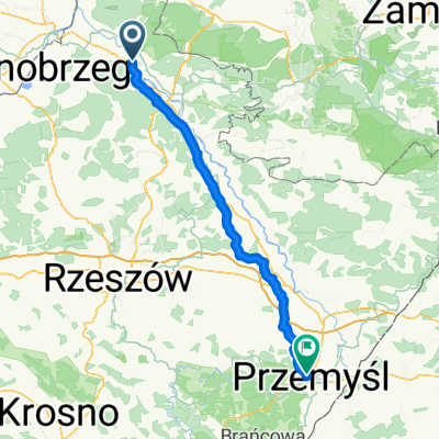
Do Ulanowa
A cycling route starting in Stalowa Wola, Subcarpathian Voivodeship, Poland.
Overview
About this route
- -:--
- Duration
- 50.1 km
- Distance
- 101 m
- Ascent
- 101 m
- Descent
- ---
- Avg. speed
- ---
- Avg. speed
Route quality
Waytypes & surfaces along the route
Waytypes
Road
16.2 km
(32 %)
Quiet road
12.6 km
(25 %)
Surfaces
Paved
36.7 km
(73 %)
Unpaved
1.6 km
(3 %)
Asphalt
34.7 km
(69 %)
Gravel
1.2 km
(2 %)
Continue with Bikemap
Use, edit, or download this cycling route
You would like to ride Do Ulanowa or customize it for your own trip? Here is what you can do with this Bikemap route:
Free features
- Save this route as favorite or in collections
- Copy & plan your own version of this route
- Sync your route with Garmin or Wahoo
Premium features
Free trial for 3 days, or one-time payment. More about Bikemap Premium.
- Navigate this route on iOS & Android
- Export a GPX / KML file of this route
- Create your custom printout (try it for free)
- Download this route for offline navigation
Discover more Premium features.
Get Bikemap PremiumFrom our community
Other popular routes starting in Stalowa Wola
- Wy艣mienita i wszechstronna trasa na wierczorne: bieganie/jazd臋 na rolkach/jazd臋 na rowerze.
- Distance
- 6.4 km
- Ascent
- 24 m
- Descent
- 26 m
- Location
- Stalowa Wola, Subcarpathian Voivodeship, Poland
- 104 (28/16) Stalowa Wola-Bojan贸w-Brz贸za Kr贸l.-呕o艂ynia-Mikulice-Ka艅czuga
- Distance
- 103.7 km
- Ascent
- 255 m
- Descent
- 218 m
- Location
- Stalowa Wola, Subcarpathian Voivodeship, Poland
- Lasem Lipskim na je偶yny
- Distance
- 50.8 km
- Ascent
- 215 m
- Descent
- 217 m
- Location
- Stalowa Wola, Subcarpathian Voivodeship, Poland
- Kr贸tki trip po lesie
- Distance
- 55.3 km
- Ascent
- 177 m
- Descent
- 177 m
- Location
- Stalowa Wola, Subcarpathian Voivodeship, Poland
- 艁膮cznik Greenvelo przez Lasy Pa艅stwowe
- Distance
- 12.7 km
- Ascent
- 33 m
- Descent
- 30 m
- Location
- Stalowa Wola, Subcarpathian Voivodeship, Poland
- Aleje Jana Paw艂a II 13A, Stalowa Wola do Aleje Jana Paw艂a II 13A, Stalowa Wola
- Distance
- 9.5 km
- Ascent
- 36 m
- Descent
- 35 m
- Location
- Stalowa Wola, Subcarpathian Voivodeship, Poland
- Stalowa Wola Rozwad贸w - Huta Szklana
- Distance
- 123.9 km
- Ascent
- 810 m
- Descent
- 537 m
- Location
- Stalowa Wola, Subcarpathian Voivodeship, Poland
- Lengthy bike tour from 15 sierpnia, 10:03
- Distance
- 49.3 km
- Ascent
- 94 m
- Descent
- 96 m
- Location
- Stalowa Wola, Subcarpathian Voivodeship, Poland
Open it in the app